
Croydon Cemetery, Queensland facts for kids
Quick facts for kids Croydon Cemetery |
|
|---|---|
.jpg)
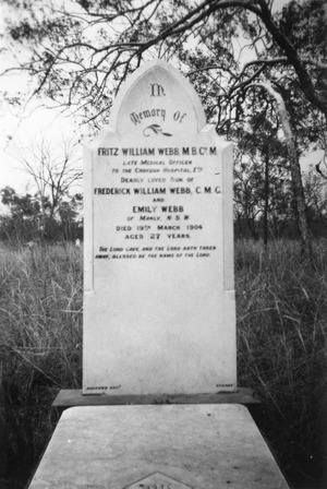
Croydon Cemetery, 2011
|
|
| Location | Julia Creek Road, Croydon, Shire of Croydon, Queensland, Australia |
| Design period | 1870s - 1890s (late 19th century) |
| Built | c. 1889 |
| Official name: Croydon Cemetery | |
| Type | state heritage (built) |
| Designated | 25 October 2002 |
| Reference no. | 602376 |
| Significant period | c. 1889 - ongoing (fabric, historical use) |
| Significant components | headstone, grave surrounds/railings, fence/wall - perimeter, gate - entrance, grave surrounds - iron bedstead/s, grave marker, burial/grave |
| Lua error in Module:Location_map at line 420: attempt to index field 'wikibase' (a nil value). | |
The Croydon Cemetery is a very old and important burial ground in Croydon, Australia. It's located on Julia Creek Road. This cemetery has been used since about 1889 and is still in use today. It's so special that it was added to the Queensland Heritage Register on October 25, 2002, which means it's protected for its historical value.
History of Croydon Cemetery
The Croydon Cemetery is one of at least ten cemeteries that served the Croydon area. This area became a goldfield in 1886. A goldfield is a place where a lot of gold is found. The land for this main cemetery was officially marked out in September 1888. It was officially recognized in 1889. However, people were probably already using it before then.
The Croydon Gold Rush
Croydon was the last big gold rush in North Queensland during the 1800s. Gold production was highest around 1900. After that, mining slowly decreased over the next 20 years. There was a small increase in mining during the 1930s. This was during the Great Depression, when many people needed work. Today, about 300 people live in the area.
Croydon is about 110 miles (177 km) west of Georgetown. It's also about 90 miles (145 km) southeast of Normanton, a port town on the Gulf of Carpentaria. Europeans first explored this region in the 1860s. Gold was first found on Croydon Downs Station in 1883. Two employees, James and Walter Alldridge, found gold in quartz rock.
In 1885, Richard and Walter Alldridge found 20 more places with gold. These discoveries were reported in October 1885. The Croydon area was officially declared a goldfield on January 18, 1886. This meant the Mines Department would manage it. The Alldridge brothers and W.C. Brown received a £1000 reward. Their first successful mine was called Lady Mary.
Life on the Goldfield
Hundreds of people quickly moved to the Croydon area. By 1887, about 7,000 people lived in the district. By 1897, it was the third most populated place in North Queensland. From 1890 to 1910, Croydon produced the second most gold in Queensland. Only Charters Towers produced more.
Life on the Croydon goldfields was hard. There wasn't enough water, grass for animals, or wood for building. Being so far away from other towns was also a big problem. This changed when the Croydon to Normanton railway was finished in 1891. The area also faced droughts, floods, and even a cyclone in 1906.
Community and Challenges
Like many goldfields, Croydon had a Chinese community. They lived on the edge of town. This community built a temple, houses, and other facilities. By late 1888, about 300 of Croydon's 3,500 people were Chinese, Cingalese, Malays, and African. These groups were very important for the community. They often worked as gardeners, carriers, and cooks.
Even with all the difficulties, the 1890s were very productive years for Croydon. By 1900, the town had many businesses. These included banks, blacksmiths, bakers, chemists, and 18 hotels. Croydon became a municipality in 1892. This meant it had its own local government.
The Cemetery's Role
Croydon was the main town, but many smaller communities grew up around the gold mines. People from these smaller places would visit Croydon on Saturdays. They would shop, do business, and socialize. This led to at least ten cemeteries being set up across the district.
The main Croydon Cemetery, Reserve R16, was surveyed in September 1888. It was the second cemetery near Croydon town. It is the only one still used today. The first recorded burial in this cemetery was F.W. Kennedy on January 5, 1889. The first grave with a headstone after the cemetery was officially recognized was likely for William Pascoe, who died on July 19, 1889.
Seventy-four Chinese burials were recorded in Croydon between 1889 and 1951. However, there might be around 130 Chinese graves in total. Sometimes, bodies were dug up and sent back to China. This was important for Chinese people who wanted to return to their homeland after death.
The cemetery shows that many people died in Croydon, especially young people. Some children's graves are marked with iron bedsteads. A lung disease called miner's phthisis was also a common cause of death for miners. Some headstones were put up by friends. This shows that many people were far from their families. It also shows that some people on the goldfields were very poor. A few headstones are very impressive. They show how wealthy some people on the goldfield became.
There is one Commonwealth war grave in the cemetery. It belongs to Lieutenant Alrey Fisher McMaster. He was in the Australian Army and died in 1947. He is listed as a casualty of World War II.
Headstone Makers
Many headstones in the cemetery were made by Melrose and Fenwick. This company started in Townsville around 1896. They later opened branches in Cairns, Charters Towers, and Mackay.
Other stonemasons also made headstones here. These include John Petrie and J H Simmons from Brisbane. Ernest Greenway from Ipswich also made some.
- John Petrie took over his father's stonemasonry business in 1848. He expanded his company to Charters Towers and Townsville in 1889.
- John Howard Simmons worked from Brisbane from about 1883 to at least 1910. He supplied headstones all over Queensland. He was one of the busiest stonemasons of his time.
- Ernest Greenway learned his trade in England. He moved to Queensland in 1882. He set up his stonemasonry business in Ipswich. His business operated until 1934.
What the Cemetery Looks Like
The Croydon Cemetery, also known as Reserve R16, covers about 4 hectares (10 acres) of land. It is about 2 kilometers (1.2 miles) south of Croydon town. You can get there from Julia Creek Road. A well-kept fence surrounds the entire cemetery. It has a gate for vehicles and a smaller gate for people walking.
The ground is mostly flat with sandy soil. The original survey notes said it had sand with sandstone underneath. Rainwater drains into Highland Mary Creek. Most of the plants are natural. There are eucalypt trees and other native trees scattered around. Native grasses cover the ground for most of the year. Many native birds and animals live in this area.
You will see many grave markers made from soldered sheet metal. These were often three-dimensional. They sometimes had ceramic flowers inside, protected by glass. This type of grave marker seems to be unique to this cemetery.
Only a small number of graves have headstones. The headstones are made from many different materials. These include shiny granite, marble, sandstone, sheet metal, cast iron, concrete, and tiles. Some headstones are starting to decay. Sandstone wears away, and marble gets damaged by the hot tropical weather.
The more detailed headstones are usually on Catholic graves. Protestant graves often have simpler headstones. Some Chinese graves have sandstone headstones. Others are marked with simple clay bricks. Many graves are surrounded by whatever materials were available. This includes metal cots and iron railings.
Why Croydon Cemetery is Important
Croydon Cemetery was added to the Queensland Heritage Register on October 25, 2002. This means it is recognized as a special historical place for several reasons.
Showing Queensland's History
The Croydon Cemetery has been used since the late 1880s. It shows how the region has grown and changed over time. The cemetery is an important record of the area's culture. It shows the different backgrounds of people, how they viewed death, what materials were available, and their jobs and social standing.
Unique Cultural Heritage
It is rare to find Chinese burials that are still complete in cemeteries on Queensland mining fields. This is because Chinese people often dug up bodies to send them back to their homeland. So, the surviving sandstone and brick headstones at Croydon, which mark complete burial sites, are very special. The cemetery is also unique because of the three-dimensional metal "vases" used as grave markers.
Learning About History
The cemetery can help us learn a lot about the early people of the Croydon goldfields. It can tell us about their ethnic backgrounds, social lives, and religious beliefs. We can also learn about the area's economy and society. This information comes from the messages on the headstones and the types of materials used. Headstones often include details like nationality, health, social status, job, religion, and cause of death. You can also see family relationships. The many single graves show how hard and lonely life was for pioneers in North West Queensland.
Showing Important Characteristics
This cemetery shows the work of several important Queensland stonemason companies. These include Melrose and Fenwick from Townsville, Ernest Greenway from Ipswich, and J Petrie and JH Simmons from Brisbane.
Special Connection to the Community
The cemetery is very important to the community for spiritual and cultural reasons. It has been used as a burial place for over 110 years. The local council, Croydon Shire Council, shows how much they care for the cemetery. They fund a plan to protect it and keep it well-maintained.
