Burke and Wills Camp B/CXIX facts for kids
Quick facts for kids Burke and Wills Camp B/CXIX |
|
|---|---|

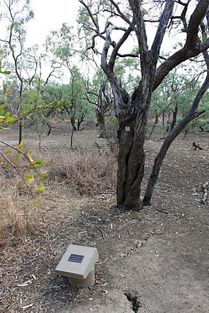
Burke and Wills Camp B-CXIX, 2010
|
|
| Location | Burke and Wills Access Road (Private Road), Normanton, Shire of Carpentaria, Queensland, Australia |
| Design period | 1840s - 1860s (mid-19th century) |
| Official name: Burke and Wills' Camp B/CXIX and Walker's Camp, Little Bynoe River, Walker's Camp | |
| Type | state heritage (archaeological, landscape) |
| Designated | 14 August 2008 |
| Reference no. | 602156 |
| Significant period | 1861-62 |
| Significant components | blazed tree/dig tree/marker tree, memorial/monument |
| Lua error in Module:Location_map at line 420: attempt to index field 'wikibase' (a nil value). | |
Burke and Wills Camp B/CXIX is a very important historical campsite. It is located near Normanton, in Queensland, Australia. This site is also known as Walker's Camp. It was added to the Queensland Heritage Register on August 14, 2008. This means it is a protected place because of its historical value.
The Story of the Camps
On February 11, 1861, four explorers from the famous Burke and Wills expedition set up their northernmost camp here. They were trying to cross Australia from south to north. This camp was next to the Bynoe River, close to the Gulf of Carpentaria.
Two of the explorers stayed at this camp for three days. The expedition leader, Robert O'Hara Burke, and the surveyor, William John Wills, went further north. They hoped to reach the Gulf coast.
While at the camp, the explorers marked 15 trees. They did this to show where their camp was located.
About 11 months later, on January 8, 1862, a search party arrived. This group was led by Frederick Walker. They also set up a camp near Burke and Wills' site. Walker's team marked a tree to show their camp. It was about 0.75 miles (1.21 km) north of the first camp.
Why the Expedition Happened
In the mid-1800s, people were very interested in science and exploring. The Royal Society of Victoria decided to send an expedition. Their goal was to cross Australia from south to north.
Many people and the Victorian Government donated money for this journey. The main aim was to explore the "centre" of Australia. This would help open up new areas.
Choosing the Leaders
The Royal Society looked for a leader for the Victorian Exploration Expedition. They chose Robert O'Hara Burke. He was a police superintendent from Victoria. Burke was born in Ireland in 1821. He had served in the military before moving to Australia in 1853.
William John Wills was chosen as the expedition's surveyor. He was also the third-in-command. Wills was born in England in 1834. He trained in medicine and came to Australia in 1853.
The Journey Begins
The instructions for the expedition were not very clear. Burke was told he could travel in any direction from Cooper's Creek. However, there was pressure to reach the "centre" quickly. Another explorer, John McDouall Stuart, was also exploring for South Australia.
Burke left Melbourne with a large group of men and supplies. When they reached Menindee, the weather was very hot. The heavy carts carrying supplies were also very slow.
Burke decided to leave some men and supplies at Menindee. He wanted to continue north quickly. He went ahead with a smaller team of eight men. He planned for the rest of the team to join him at Cooper's Creek later.
Reaching the Gulf
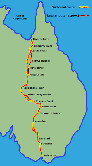
At Cooper's Creek, Burke decided to make a fast trip to the Gulf. He went with Wills, Charles Gray, and John King. They wanted to get there before the wet season started.
This northern group had Burke as the leader. Wills was second-in-command and handled navigation. King looked after the camels, and Gray organised the camp.
On February 11, 1861, Burke's team reached the Little Bynoe River. This was 57 days after leaving Cooper's Creek. It was also 13 days longer than they had planned.
Burke and Wills' Camp B/CXIX became their most northern camp. Thick mangrove swamps stopped them from going further to the Gulf. They were also running low on supplies. They worried about meeting the rest of their team back at Cooper's Creek.
So, Burke and Wills left Gray and King at Camp B/CXIX. They tried to push through the mangroves to reach the coast. But after three difficult days, they turned back. They picked up Gray and King at Camp B/CXIX. The explorers left only 15 marked trees as evidence of their stay. These were Coolibah and Gutta-percha trees.
What are Blazed Trees?
Early Australian explorers often marked their paths by "blazing" trees. This means they cut a mark into the tree trunk. These marks showed the routes they took. They also marked important spots along their journey.
Common markings included the explorer's initials and the date. They also used a unique number for each camp. For example, "B/CXIX" means Burke's 119th camp. These markings helped match the trees to entries in the explorers' diaries. This way, we can learn what happened at certain locations.
The Difficult Return
Between February 14 and April 21, 1861, the four men struggled back to Cooper's Creek. They had few supplies, and their camels were failing. Charles Gray became very ill. He suffered from headaches and body pains. His health got worse, and he died on April 17, 1861.
Travel was so slow that the team waiting at Cooper's Creek gave up hope. After four months, they buried messages and food at a tree. Then they left the camp to get help.
Just hours later, Burke, Wills, and King returned to the camp. They thought they were alone and didn't know about the buried supplies. The three men tried to reach the nearest police station at Mount Hopeless.
However, the land was very difficult. The explorers and their two remaining camels were in bad health. They had to stay along Cooper's Creek. Both Burke and Wills died there in late June. King was cared for by local Aboriginal people. He survived until a search party, led by Alfred William Howitt, rescued him in September 1861.
Walker's Search Party
Many people were sent to search for the lost explorers. One of them was Frederick Walker. He had already explored for farmers in 1860 and 1861. In late 1861, Walker led a party to find the Burke and Wills expedition.
Walker set up his own camp near a small seasonal lagoon. Over the next four days, he found Burke and Wills' Camp B/CXIX. It was about three-quarters of a mile away. Walker's party also left several blazed trees near their campsite.
The Camps Today
In the early 1860s, a cattle station called Magowra Station was set up. It included both Camp B/CXIX and Walker's nearby camp. The town of Normanton was established in 1864. It was a port and service center for the surrounding farms. Normanton is about 35 kilometres (22 mi) from Camp B/CXIX.
Burke and Wills' Camp B/CXIX and Walker's Camp were "lost" until 1909. That's when staff from Magowra Station found Walker's blazed trees. They also found the blazed trees at Camp B/CXIX. JP Thomson of the Royal Geographical Society of Queensland wrote about finding 15 blazed trees.
In 1999, David Hillian visited the site again. He found 10 blazed trees. Some trees have been lost over time. For example, Tree Number 6 was moved to the Normanton Railway Museum.
What the Camps Look Like Today
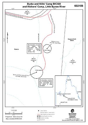
Burke and Wills' Camp B/CXIX and Walker's Camp are about 35 kilometres (22 mi) southwest of Normanton. They are also about 2 kilometres (1.2 mi) south of the Normanton-Burketown Road. Both sites are located above the water on small, seasonal overflows of the Little Bynoe River.
You can reach both campsites by the Burke and Wills Access Road. This road runs south from the Normanton-Burketown Road. The sites are on dusty land. They don't show obvious signs of the dramatic events that happened there.
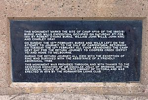
Burke and Wills' Camp B/CXIX has signs and memorials. A graded track surrounds it. Visitors can drive vehicles onto the site using this track.
The camp is marked by 10 blazed trees. These trees were marked during the explorers' three-day stay. The blazes are not very obvious. This has probably helped them survive over the years.
Walker's Camp is within an overflow of the Little Bynoe River. It is marked by one blazed tree. A stainless steel plaque is attached to it. It says "Walker's Camp, 8-12th Jan 1862 DNH 1998". Visitors need to walk about 500 metres (1,600 ft) through the bush to reach this site.
The Carpentaria Shire Council has added signs and protection to the site. They have put up interpretive signs and bollards. These help protect the site and limit access. There is also a protective shelter and a car park. These additions are not part of the original historical value.
Why These Camps Are Important
Burke and Wills' Camp B/CXIX and Walker's Camp are listed on the Queensland Heritage Register. This means they are very important to Queensland's history.
Showing History's Patterns
These camps show how Queensland's history developed. They reflect the interest in scientific exploration in the 1800s. They also show the exploration of central and northern Australia. Burke and Wills Camp B/CXIX was the most northern camp marked during their expedition.
The camps also show how exploration helped open up Australia for farming and ranching. This process changed the Gulf region forever after the expedition.
These places are important to the wider community. They are a physical reminder of the Burke and Wills Expedition. They also show the search effort made by Walker's party. Burke and Wills' Camp B/CXIX is a significant landmark.
Rare Historical Evidence
The blazed trees at both camps are very rare. Along with the "Dig Tree" at Cooper's Creek, they are some of the few remaining physical signs of the Burke and Wills Expedition. They also show Frederick Walker's search.
These blazed trees are rare because they are still identifiable. They have survived since 1861 in a remote and difficult environment.
Potential for New Information
These camps could still provide more information. They might help us learn more about how explorers worked in the 1800s. This is especially true for northern Queensland and Australia.
If other campsites from the Burke and Wills expedition are found, these camps could help us understand them better. They could also help us compare them to other exploration events.
Showing Key Characteristics of Exploration
Burke and Wills' Camp B/CXIX and Walker's Camp show a key part of early exploration in Queensland. Explorers marked their campsites with blazes. This was to record information for future travelers. These blazed trees are very old, still mostly complete, and rare. This makes the site an excellent example of its kind.
Special Connection to Important People
These camp sites have a special connection to Robert O'Hara Burke, William John Wills, and Frederick Walker. They were very important figures in Australian and Queensland exploration in the 1800s.
 | Mary Eliza Mahoney |
 | Susie King Taylor |
 | Ida Gray |
 | Eliza Ann Grier |


