Bellenden Ker Range facts for kids
Quick facts for kids Bellenden Ker |
|
|---|---|
| Wooroonooran | |

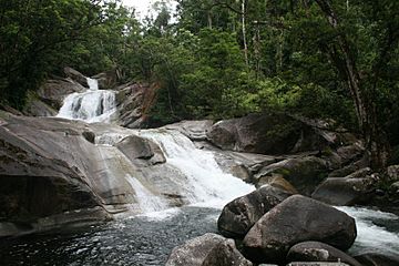
Josephine Falls in Wooroonooran National Park.
|
|
| Highest point | |
| Peak | Mount Bartle Frere |
| Elevation | 1,622 m (5,322 ft) |
| Geography | |
| Country | Australia |
| State | Queensland |
| Region | Far North Queensland |
| Range coordinates | 17°14′S 145°52′E / 17.233°S 145.867°E |
| Parent range | Great Dividing Range |
The Bellenden Ker Range, also known as the Wooroonooran Range, is a group of mountains found along the coast in Far North Queensland, Australia. It is part of the larger Great Dividing Range. These mountains are located between the towns of Gordonvale and Babinda.
This entire mountain range is part of the Wet Tropics World Heritage Area. This means it is a very special place, recognized globally for its amazing natural beauty. The area is covered in lush, wet tropical forests. These forests are home to many unique plants and animals that are found nowhere else in the world.
The Bellenden Ker Range is also important for birds. It is part of the Wooroonooran Important Bird Area. This area helps protect many bird species that live only in Queensland's Wet Tropics. Most of the range is also a protected area called Wooroonooran National Park.
Queensland's two tallest mountains are found here. They are Mount Bartle Frere, which is 1,622 meters (5,322 feet) high, and Mount Bellenden Ker, which is 1,593 meters (5,226 feet) high. At the northern end of the range, you can see Walshs Pyramid. This mountain is 922 meters (3,025 feet) tall and looks like a giant natural pyramid.
History of the Range
The Bellenden Ker mountains were first seen by Lieutenant James Cook a long time ago. However, they were not given their official name until June 22, 1819. On that day, Lieutenant Phillip Parker King named them while he was on his ship, the Mermaid.
Lieutenant King named the range after an English botanist named John Bellenden Ker Gawler. This idea came from his ship's own botanist, Allan Cunningham. Later, an early explorer named Archibald Meston also explored parts of this mountain range.
Rivers and Waterfalls
Many rivers and waterfalls are found in the Bellenden Ker Range. The Mulgrave River starts on the southwestern side of the mountains. It then flows north around the top of the range before turning south. It runs parallel to the eastern side of the mountains.
The Russell River drains the southeastern parts of the range. You can also find many beautiful waterfalls here. Some of these include Kearneys Falls, Fishery Falls, Josephine Falls, Tchupala Falls, Wallicher Falls, Nandroya Falls, Silver Creek Falls, Whites Falls, and Clamshell Falls.
 | Bessie Coleman |
 | Spann Watson |
 | Jill E. Brown |
 | Sherman W. White |

