
Mount Bartle Frere facts for kids
Quick facts for kids Mount Bartle Frere |
|
|---|---|
| Choorechillum | |

View from the south east
|
|
| Highest point | |
| Elevation | 1,611 m (5,285 ft) |
| Geography | |

Mount Bartle Frere
Location in Queensland
|
|
| Location | Queensland, Australia |
| Parent range | Bellenden Ker Range |
| Climbing | |
| First ascent | Christie Palmerston, 26 October 1886 |
| Easiest route | Western side |
Mount Bartle Frere is the tallest mountain in Queensland, Australia. It stands at an amazing 1,611 metres (5,285 ft) (about 5,285 feet) high! The local Ngajanji people call it Choorechillum.
This impressive mountain was named in 1873 by George Elphinstone Dalrymple. He named it after Sir Henry Bartle Frere, who was a British leader and also led the Royal Geographical Society.
Mount Bartle Frere is located about 51 kilometres (32 mi) south of Cairns. It's found within the Wooroonooran National Park, which is southwest of the town of Babinda. The mountain is part of the Bellenden Ker Range.
The entire mountain, from its base to its top, is covered in thick rainforest. At lower parts, it's a typical tropical rainforest. Higher up, it changes into a cooler cloud forest. Up at the summit, temperatures can be much lower than on the coast. Even though it's a tough climb, reaching the top gives you an amazing view of the area around it.
Contents
History of Mount Bartle Frere
The first European person to climb Mount Bartle Frere was Christie Palmerston in 1886. He marked a tree at the very top with "P October 26, '86" to show he had made it. The mountain's close neighbor, Mount Bellenden Ker, is the second highest mountain in Queensland.
On April 21, 1942, during World War II, an American Air Force B-25 Mitchell bomber plane crashed on the mountain. Sadly, all seven crew members on board lost their lives. This plane had just returned from a mission against Japanese forces in the Philippines.
Climbing Mount Bartle Frere
When the sky is clear, climbing to the top of Mount Bartle Frere offers incredible views. You can see both the flat coastal areas and the Atherton Tablelands. The climb can be very steep in some places, and you might need to scramble over rocks.
It's important to be prepared when climbing this mountain. The weather can change very quickly. Many people have gotten lost while climbing, sometimes for several days. This happens because the weather is unpredictable, people don't prepare enough, or the track markers are hard to see.
However, if you are an experienced climber and start early from the Josephine Falls car park, you should be able to reach the summit safely.
Josephine Falls Route
The total distance from Josephine Falls and back is 15 kilometres (9.3 mi). This route usually takes about 10 to 12 hours to complete. You will climb about 1,500 metres (4,900 ft) in height.
This part of Queensland gets a lot of rain every year. So, it's common for the mountain peak to be covered in clouds. The best time to climb Mount Bartle Frere is during the winter months (June to October). The weather is cooler then, and there is less chance of rain. There are orange markers every kilometer along the trail, but some of them can be hard to spot.
Western Side Route
There is an easier way to climb Mount Bartle Frere from a small campsite on the western side. You can reach this campsite by car using Topaz Road and Gourka Road. From this starting point, which is already at an altitude of 700 metres (2,300 ft), it's easier to climb to the top and come back down in one day.
This western route is popular with local bushwalking clubs. It's also best to try this climb during the dry winter months, from June to October. Walking during the wet season (December to April) can be risky. You might face heavy tropical rain, poor visibility, and leeches. Sometimes, rocks can also slip on the trail.
There is also a shorter 10 kilometres (6.2 mi) return trail from Josephine Falls to a spot called 'Broken Nose'. This is a spur (a smaller ridge) on the southern side of the mountain. While there's a big map at the Josephine Falls car park, there are no other maps or ranger stations before you start the climb.
Environment of Mount Bartle Frere
Climate
Even though there isn't a rain gauge directly on Mount Bartle Frere, data from nearby Mount Bellenden Ker gives us an idea of how wet it is. The average rainfall there is around 8,000 millimetres (310 in) each year. It's even thought that it could get as much as 17,000 millimetres (670 in) in some years! This would make the mountain one of the wettest places in the world.
Even during the "dry" season in tropical Australia, Mount Bartle Frere gets a lot of rain. For example, it can get about 800 millimetres (31 in) in May and 350 millimetres (14 in) in August. In March, which is the wettest month, it's estimated to get as much as 1,800 millimetres (71 in) on average, and sometimes up to 6,000 millimetres (240 in).
Scientists have even calculated that during a tropical cyclone in 1911, the mountain might have received as much as 2,000 millimetres (79 in) of rain in a single day! If this is true, it would be the highest daily rainfall ever recorded in the world.
Vegetation and Unique Plants
The high altitude and heavy rainfall on Mount Bartle Frere create special conditions for many types of plants. The soil is poor because the rain washes away nutrients.
- Lower Slopes: These areas have thick tropical rainforests with many different kinds of large-leaved trees, climbing plants, epiphytes (plants that grow on other plants), palms, and ferns.
- Higher Elevations: As you go higher, the rainforest changes. The trees have smaller leaves and there are fewer types of plants. Above 1,000 metres (3,300 ft), you'll find trees like the purple kauri pine (Agathis atropurpurea).
- Cloud Forest: Even higher up, above 1,500 metres (4,900 ft), the mountain is often covered in clouds. This creates a special "cloud forest" where many trees are covered in mosses and other tiny plants called bryophytes. Many of the plant species here are rare or found nowhere else in the world.
One very special tree, Eucryphia wilkei, only grows in the cloud forest on Mount Bartle Frere. Its relatives are found in cooler rainforests in Tasmania and Chile. Other unique plants include the mountain aspen (Acronychia chooreechillum) and Australia's only native rhododendron, Rhododendron lochiae. This rhododendron grows on large granite rocks or as an epiphyte in the cloud forest. The plant Eidothea zoexylocarya was first found on Mount Bartle Frere, and most of its populations are still there.
In some areas near the summit, the soil is so poor that rainforest plants are replaced by heath plants. These include small shrubs like Acrothamnus spathaceus, ferns, carnivorous sundews (Drosera species), and a type of orchid called Dipodium ensifolium.
Animals and Birds
Mount Bartle Frere is home to some unique animals.
- Bartle Frere Skink: The Bartle Frere skink is an endangered type of lizard. It is found only on the slopes of Mount Bartle Frere and nearby peaks above 1,400 metres (4,600 ft).
- Other Lizards: Two other lizard species, Bellatorias frerei and Concinnia frerei, are named after the mountain.
- Important Bird Area: Mount Bartle Frere is part of the Wooroonooran Important Bird Area. This means it's a very important place for birds. BirdLife International has identified it because it supports many bird species that are found only in Queensland's Wet Tropics region.
Images for kids
-
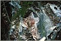
The US "star" insignia is still clearly visible in this 1983 photograph of the wreckage of the crashed bomber on the mountain.

