Mount Bellenden Ker facts for kids
Quick facts for kids Mount Bellenden Ker |
|
|---|---|

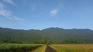
Mount Bellenden Ker summit and aerial cableway from Bruce Highway
|
|
| Highest point | |
| Elevation | 1,593 m (5,226 ft) |
| Geography | |
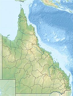
| Location | Queensland, Australia |
| Parent range | Bellenden Ker Range |
Mount Bellenden Ker is the second-tallest mountain in Queensland, Australia. It stands at about 1,593 meters (5,226 feet) high. The mountain was named after a botanist named John Bellenden Ker Gawler.
You can find Mount Bellenden Ker about 60 kilometers (37 miles) south of Cairns and close to Babinda. It's right next to Mount Bartle Frere, which is the tallest mountain in Queensland. Both mountains are part of the Bellenden Ker Range, also known as the Wooroonooran Range.
These two huge mountains are a big part of the Josephine Falls area within the Wooroonooran National Park. They are made of strong granite rock. Over time, the Russell River and Mulgrave River have worn away the land around them, leaving these tough peaks standing tall.
You'll also see several television transmitter towers on the mountain. The only way to reach these towers and a special weather station at the top is by a private cable car.
Contents
Exploring Mount Bellenden Ker's Past
Early Expeditions to the Summit
In 1873, Walter Hill, who was Queensland's first official botanist, went on a trip to northern Queensland. He collected native plants and also visited Mount Bellenden Ker.
In the same year, Robert Arthur Johnstone climbed the peak. He was exploring the coastal areas south of Cooktown with George Elphinstone Dalrymple. Later, in early 1889, another group led by Archibald Meston also made an expedition to the mountain's summit.
Nature and Wildlife at Mount Bellenden Ker
Birds of the Wet Tropics
Mount Bellenden Ker is part of a special area called the Wooroonooran Important Bird Area. This area is recognized by BirdLife International because it's home to many unique bird species. These birds live only in Queensland's Wet Tropics region.
Understanding Mount Bellenden Ker's Weather
Australia's Wettest Place
The top of Mount Bellenden Ker has a rain gauge that measures how much rain falls. On average, it gets about 8,053.6 millimeters (317 inches) of rain each year. This makes it the wettest weather station in all of Australia!
The mountain also holds some rainfall records. In the year 2000, it received 12,461 millimeters (491 inches) of rain, which is the most ever recorded in Australia for a single year. In January 1979, it got 5,387 millimeters (212 inches) of rain, setting a record for the wettest month in Australia.
Rainfall Records and Cyclones
In 2006, Mount Bellenden Ker received more rain than any other place in Australia, with 9,800 millimeters (386 inches). This happened mostly because two strong tropical cyclones passed very close to the mountain.
In 2010, which was Queensland's wettest year on record, the station at the top of the mountain recorded 12,438.4 millimeters (489.7 inches) of rain. This was just a little less than the record set in 2000.
| Climate data for Mount Bellenden Ker (top station); elevation: 1,545 metres (5,069 ft) | |||||||||||||
|---|---|---|---|---|---|---|---|---|---|---|---|---|---|
| Month | Jan | Feb | Mar | Apr | May | Jun | Jul | Aug | Sep | Oct | Nov | Dec | Year |
| Average rainfall mm (inches) | 996.9 (39.25) |
1,201.7 (47.31) |
1,304.4 (51.35) |
1,082.5 (42.62) |
784.1 (30.87) |
457.2 (18.00) |
402.0 (15.83) |
309.8 (12.20) |
279.1 (10.99) |
340.1 (13.39) |
367.4 (14.46) |
564.7 (22.23) |
8,053.6 (317.07) |
| Source: Bureau of Meteorology | |||||||||||||
| Climate data for Mount Bellenden Ker (bottom station); elevation: 97 metres (318 ft) | |||||||||||||
|---|---|---|---|---|---|---|---|---|---|---|---|---|---|
| Month | Jan | Feb | Mar | Apr | May | Jun | Jul | Aug | Sep | Oct | Nov | Dec | Year |
| Average rainfall mm (inches) | 675.8 (26.61) |
830.7 (32.70) |
813.9 (32.04) |
582.0 (22.91) |
339.0 (13.35) |
177.5 (6.99) |
137.4 (5.41) |
121.6 (4.79) |
136.1 (5.36) |
167.4 (6.59) |
276.9 (10.90) |
380.3 (14.97) |
4,546.3 (178.99) |
| Source: Bureau of Meteorology | |||||||||||||
 | Delilah Pierce |
 | Gordon Parks |
 | Augusta Savage |
 | Charles Ethan Porter |


