
Clifton, Queensland facts for kids
Quick facts for kids CliftonQueensland |
|||||||||||||||
|---|---|---|---|---|---|---|---|---|---|---|---|---|---|---|---|

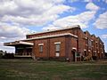
The Old Clifton Butter Factory, 2007. Now demolished.
|
|||||||||||||||

Clifton
Location in Queensland
|
|||||||||||||||
| Population | 1,490 (2021 census) | ||||||||||||||
| • Density | 32.46/km2 (84.1/sq mi) | ||||||||||||||
| Established | 1840 | ||||||||||||||
| Postcode(s) | 4361 | ||||||||||||||
| Area | 45.9 km2 (17.7 sq mi) | ||||||||||||||
| Time zone | AEST (UTC+10:00) | ||||||||||||||
| Location | |||||||||||||||
| LGA(s) | Toowoomba Region | ||||||||||||||
| State electorate(s) | Condamine | ||||||||||||||
| Federal Division(s) | Maranoa | ||||||||||||||
|
|||||||||||||||
Clifton is a small rural town in Queensland, Australia. It is part of the Toowoomba Region. In 2021, about 1,490 people lived in Clifton.
Contents
Where is Clifton Located?
Clifton is in a farming area called the Darling Downs. It's about 50 kilometres (31 mi) (31 miles) south of Toowoomba. The big city of Brisbane is about 150 kilometres (93 mi) (93 miles) to the west.
The New England Highway runs along the eastern side of the town. Other roads connect Clifton to nearby places. The South Western railway line also goes through the town. You can find the Clifton railway station here.
Did you know? There's an airfield called Bange's Airfield near Clifton. It's a place where people fly ultralight aircraft. You might even see some special Boab trees along the main street.
What is Clifton's History?

The area around Clifton was first settled by Europeans in 1840. The town got its name from a large farm called a "pastoral run" around 1844.
The Clifton Post Office opened in 1869. For a short time, it was known as King's Creek.
Early Schools in Clifton
Several schools opened in Clifton over the years:
- Clifton Colliery Provisional School started in 1876. It closed in 1936.
- Clifton Homestead Area State School opened around 1879 and closed around 1918.
- Clifton State School opened in 1892. It later added a secondary department in 1964.
- Clifton State High School opened as its own school in 1966.
- St Francis De Sales' Catholic School opened in 1917. It was run by a group of nuns called the Sisters of the Good Samaritan.
Churches in Clifton
Many churches were built in Clifton:
- The Roman Catholic Church of St James and St John opened in 1888. A new, bigger Catholic church opened in 1900.
- A Presbyterian church was built in 1890. A larger one, St Andrew's Presbyterian Church, opened in 1909.
- All Saints' Anglican Church was first built in 1889 and then rebuilt in 1905.
- A Methodist Church was built in 1900 but has since closed.
Important Memorials
The Clifton War Memorial is a special place to remember soldiers. It is located on the corner of King and Edward Streets.
In 2000, a memorial was put up in Centenary Park for Australian country music singer-songwriter Stan Coster.
Education in Clifton
Clifton has several schools for students of different ages.
- Clifton State School is a primary school for students from Prep to Year 6. It is located on Tooth Street.

- Clifton State High School is a secondary school for students from Year 7 to Year 12. It is located on East Street.

- Clifton Cluster Special Education Program is a special education program for students from Prep to Year 12. It is part of Clifton State High School.
- St Francis De Sales School is a Catholic primary school for students from Prep to Year 6. It is located on Meara Place.
What to Do in Clifton
Clifton has some great places to visit and things to do.
- Clifton Library is a public library operated by the Toowoomba Regional Council. It is open five days a week.

- Clifton Historical Museum used to be in the old butter factory. It showed old farming tools and machines. It was run by volunteers.
- Stan Coster Memorial is in Centenary Park. It honors the famous Australian country music singer-songwriter.
- Churches in Clifton include All Saints' Anglican Church, St James' and St John's Catholic Church, and St Andrew's Presbyterian Church.

Images for kids
-
The Old Clifton Butter Factory, 2007. Now demolished.
