Peregian Beach facts for kids
Quick facts for kids Peregian BeachQueensland |
|||||||||||||||
|---|---|---|---|---|---|---|---|---|---|---|---|---|---|---|---|

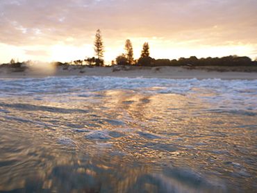
Peregian Beach, 2012
|
|||||||||||||||
| Population | 4,972 (2021 census) | ||||||||||||||
| • Density | 289.1/km2 (749/sq mi) | ||||||||||||||
| Established | 1960 | ||||||||||||||
| Postcode(s) | 4573 | ||||||||||||||
| Area | 17.2 km2 (6.6 sq mi) | ||||||||||||||
| Time zone | AEST (UTC+10:00) | ||||||||||||||
| Location | |||||||||||||||
| LGA(s) |
|
||||||||||||||
| State electorate(s) |
|
||||||||||||||
| Federal Division(s) | Wide Bay | ||||||||||||||
|
|||||||||||||||
Peregian Beach is a lovely coastal town in Queensland, Australia. It's located on the famous Sunshine Coast. This town is special because it's split between two local government areas. The part by the beach is in the Shire of Noosa, and the area further inland is in the Sunshine Coast Region. In 2021, about 4,972 people lived here.
Contents
Exploring Peregian Beach
Peregian Beach is known for its beautiful, unspoiled shoreline. It's a relaxed place with a laid-back atmosphere. The beach offers safe swimming, especially in areas watched by lifeguards. The waves are also great for surfing, bodyboarding, and other fun water activities.
Geography of the Area
Peregian Beach has two main parts. The eastern part, which is in the Sunshine Coast Region, has many homes built along the sandy beaches. The main road, David Low Way, runs through this area. To the west, the Noosa National Park helps protect the natural environment.
The western part of Peregian Beach is in the Shire of Noosa. This area is further inland and is bordered by Lake Weyba to the north. It also has parts of Noosa National Park and Murdering Creek. This western side is not as built up and has fewer homes.
A Look at Peregian's Past
Traditional Owners and Name
The Gubbi Gubbi people are the traditional owners of the Peregian area. They are an Aboriginal group who lived here for thousands of years. They used to live inland during the colder months and move to the coast in the summer. They had a camp site near Lake Weyba.
The name Peregian comes from the Kabi Kabi language. It means emu or might come from words meaning mangrove seeds. A nearby hill, Mount Peregian, used to be called Emu Mountain.
Early Development
During World War II, Peregian Beach and nearby areas were used for artillery training. This means soldiers practiced shooting cannons here. Sometimes, old shells or unexploded items are still found in the area.
The town started to grow in 1960 when the first house was built on Pelican Street. The town was officially named Peregian in 1966. It was later renamed Perigian Beach in 1972.
Peregian Beach College
Peregian Beach Community Primary School opened in 2002. It started offering secondary schooling in 2006. The first students to finish Year 12 graduated in 2012. The school is now called Peregian Beach College.
Community Art and Innovation
In 2015, local residents voted for artwork to decorate the Peregian Beach Reservoir. The winning art, called "Peregian Stand," showed a group of melaleuca trees. It was created by local artist Colin Passmore.
In 2018, the Peregian Beach Digital Hub was opened. This special building was made for technology companies to work together. It was built where the old Peregian Bowls Club used to be.
Recent Events
In September 2019, Peregian Beach was affected by bushfires. These fires were believed to have been started by two teenagers. About 200 firefighters worked for two days to control the blaze.
Today, Peregian Beach is a calm seaside town with a 4-kilometer long beach where lifeguards patrol.
Who Lives in Peregian Beach?
The number of people living in Peregian Beach has grown over the years.
- In 2011, about 3,531 people lived here.
- In 2016, the population grew to 3,791 people.
- By 2021, the population reached 4,972 people.
Learning in Peregian Beach
Peregian Beach Community College is a private school for students from Prep (the first year of school) all the way to Year 12. It is located at 41 Old Emu Mountain Road (26°28′45″S 153°04′05″E / 26.4793°S 153.0680°E).
There are no government schools directly in Peregian Beach. The closest government primary schools are in nearby Peregian Springs and Sunshine Beach. The nearest government high school is Coolum State High School in Coolum Beach.
Local Economy
The Peregian Digital Hub is a special building designed for technology companies. It helps them work together and create new ideas. You can find it at 253-255 David Low Way (26°28′42″S 153°05′42″E / 26.47833°S 153.09507°E).
Fun Things to Do
Peregian Beach is a great place for a relaxing coastal getaway. It's known for its beautiful, untouched beaches. You can swim safely in the patrolled areas, and the waves are perfect for surfing or bodyboarding.
The town also hosts regular local events. These include live music sessions, market days where you can find local crafts and food, and seasonal festivals. These events add a lively touch to the peaceful beach environment.
Community Services
The Shire of Noosa provides a weekly mobile library service. This library on wheels visits Woodland Drive, bringing books and resources to the community.
Getting Around
The David Low Way is the main road that goes through Peregian Beach. Bus services (Routes 620 and 630) connect the town to other places like Noosa Junction and Maroochydore.


