Cumulonimbus flammagenitus facts for kids

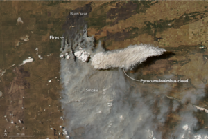
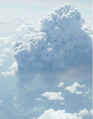
A cumulonimbus flammagenitus cloud (often called CbFg) is also known as a pyrocumulonimbus cloud. It is a special type of cumulonimbus cloud that forms when there is a lot of heat. This heat usually comes from big events like wildfires or volcanic eruptions. Sometimes, these clouds can even help put out the fire that created them!
The pyrocumulonimbus is the most extreme kind of a flammagenitus cloud. A flammagenitus cloud is a cumulus cloud that forms from the rising heat of a fire. It can also be made bigger by hot air from industrial burning.
Just like regular cumulus clouds can grow into large cumulonimbus clouds, a CbFg is a fire-made cloud that grows very tall. It can reach high into the troposphere or even the lower stratosphere. These powerful clouds can bring rain (though usually light), hail, lightning, very strong winds near the ground, and sometimes even tornadoes. All these things together can make fires spread much faster. They also create new dangers on the ground, beyond the fire itself.
Scientists first noticed CbFg clouds and their connection to fires in 1998. They found that these extreme fire clouds could send large amounts of smoke high into the lower stratosphere. This smoke can stay in the air for weeks. It can also block sunlight from reaching the ground. This is similar to what people call the "nuclear winter" effect.
In 2002, instruments detected 17 different CbFg clouds in North America alone. On August 8, 2019, an airplane flew through a pyrocumulonimbus cloud near Spokane, Washington. This flight helped scientists study the smoke particles. They also learned more about how these clouds form and their effects on the environment and air quality. It was one of the most detailed flights into a CbFg cloud ever. In 2021, about 83 cumulonimbus flammagenitus clouds formed.
What are Pyrocumulonimbus Clouds Called?
You might see different names for cumulonimbus flammagenitus. Some common ones are Cb-Fg, pyrocumulonimbus, pyro-cumulonimbus, pyroCb, pyro-Cb, and volcanic cb. These names came from different groups of experts. In the news, people often say that fires are "making their own weather."
The World Meteorological Organization (WMO) is a group that names and classifies clouds. They do not see CbFg as a completely separate cloud type. Instead, they classify it as a cumulonimbus cloud that is also a flammagenitus cloud. The WMO uses Latin words for cloud names. The word 'pyro' comes from Greek, meaning fire.
In 2017, the WMO updated its WMO International Cloud Atlas. It says that any cumulonimbus cloud clearly caused by local heat sources, like fires, should be called a "flammagenitus" cloud.
Famous Pyrocumulonimbus Events
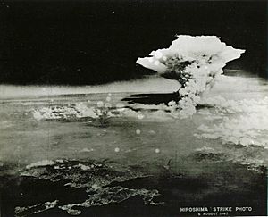
1945 Hiroshima Firestorm, Japan
On August 6, 1945, a very strong cloud, like a cumulonimbus, was seen over Hiroshima. This happened long after the cloud from the atomic bomb had disappeared. This new cloud formed because of the huge firestorm that burned the city. The firestorm and bomb blast killed about 70,000 to 80,000 people. This was about 30% of Hiroshima's population at the time.
1991 Pinatubo 'Volcanic Thunderstorms', Philippines
Volcanic eruptions can also create CbFg clouds. In 1991, after the big eruption of Mount Pinatubo in the Philippines, US military observers saw "volcanic thunderstorms." These were cumulus clouds that formed near the top of the ash plume. They often grew into full thunderstorms.
These thunderstorms sometimes moved away from the volcano. They caused heavy local rainfall, "mudfall" (rain mixed with ash), and ash falling to the ground. Scientists found that the volcano made it easier for thunderstorms to form. They often started earlier in the day and more reliably than in nearby areas.
2003 Canberra Firestorm, Australia
On January 18, 2003, several CbFg clouds formed from a severe wildfire. This happened during the 2003 Canberra bushfires in Canberra, Australia. One of these clouds created a huge fire tornado. This tornado was rated F3 on the Fujita scale, which measures tornado strength. It was the first confirmed powerful fire tornado. The tornado and the fire killed 4 people and injured 492 others.
2009 Black Saturday, Australia
On February 7, 2009, the Black Saturday bushfires in Victoria, Australia, were devastating. They killed 173 people and destroyed over 2,000 homes. More than 450,000 hectares (about 1.1 million acres) burned. The fires caused over four billion Australian dollars in damage. Many fire plumes created several distinct CbFg clouds that day. Some reached heights of 15 kilometers (9 miles) and produced a lot of lightning.
2019 Black Summer, Australia
On December 30, 2019, two fire trucks were overturned by what was called a 'fire tornado'. This happened near Jingellic, New South Wales, Australia. It came from an active cumulonimbus flammagenitus cloud. On that day, many CbFg clouds were recorded in the nearby State of Victoria. Some reached an altitude of at least 16 kilometers (10 miles). One of the overturned vehicles weighed between 8 and 12 tons. The incident resulted in one death and injuries to two other people.
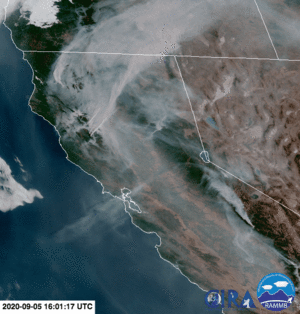
2020 Creek Fire, United States
The Creek Fire started on September 4, 2020, in California. By September 8, it was one of the 20 largest wildfires ever seen in California. It had burned 152,833 acres (about 618 square kilometers) and was not contained at all. The fire grew very quickly. Hot, windy, and dry weather, along with a drought and dead trees, helped it spread. This fire created a huge pyrocumulonimbus cloud. NASA said it was the largest such cloud ever seen in the United States.
2021 British Columbia Firestorm, Canada
Many cumulonimbus flammagenitus clouds appeared over British Columbia and northwestern Alberta in 2021. This was due to the 2021 British Columbia wildfires. These fires were made worse by a historic 2021 Western North America heat wave. In just 15 hours, from June 30 to July 1, over 710,000 lightning strikes were recorded. More than 112,000 of these were cloud-to-ground strikes.
This happened after several days of record-breaking temperatures. Canada's highest-ever recorded temperature of 49.6°C (121.3°F) was in Lytton, British Columbia. At least 19 wildfires started between June 27 and 29. Two large fires grew out of control on June 30. One near Kamloops Lake grew to 200 square kilometers (77 square miles). Another north of Lillooet also grew to tens of square kilometers. At least two people could not escape the fast-moving firestorm and died.
2021 Bootleg Fire, United States
During the Bootleg Fire in Oregon in July 2021, a weather forecaster told the New York Times that the fire created pyrocumulus clouds almost every day. Some of these clouds reached as high as 30,000 feet (9 kilometers). The fire also caused a pyrocumulonimbus cloud to form nearly 45,000 feet (13.7 kilometers) high. This cloud brought lightning and rain.
See also
 In Spanish: Cumulonimbus flammagenitus para niños
- Atmospheric convection
- Flammagenitus
- Heat dome


