Berambing, New South Wales facts for kids
Quick facts for kids BerambingNew South Wales |
|||||||||||||||
|---|---|---|---|---|---|---|---|---|---|---|---|---|---|---|---|

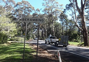
Berambing on the Bell's Line of Road
|
|||||||||||||||
| Population | 106 (2016 census) | ||||||||||||||
| • Density | 24.7/km2 (64/sq mi) | ||||||||||||||
| Established | 1832 | ||||||||||||||
| Postcode(s) | 2758 | ||||||||||||||
| Elevation | 780 m (2,559 ft) | ||||||||||||||
| Area | 4.3 km2 (1.7 sq mi) | ||||||||||||||
| Location |
|
||||||||||||||
| LGA(s) |
|
||||||||||||||
| State electorate(s) |
|
||||||||||||||
| Federal Division(s) | Macquarie | ||||||||||||||
|
|||||||||||||||
Berambing is a small country area in the Blue Mountains of New South Wales, Australia. It is located along the Bells Line of Road, between the towns of Windsor and Lithgow. Berambing is about 10 kilometers (6 miles) west of Bilpin.
This area is special because it sits across two local government areas: the City of Hawkesbury and the City of Blue Mountains. In 2016, only 106 people lived here. Berambing is famous for its farms that grow apples, nuts, and stone fruits like peaches. Many people visit Berambing to enjoy its beautiful nature. It's also very close to the Mount Tomah Botanic Garden and two big national parks: Wollemi and Blue Mountains.
Contents
History of Berambing
Who Lived Here First?
The land where Berambing is located was originally the home of the Darkiñung people. European settlers sometimes called them ‘The Branch’ natives. These Aboriginal people used the name 'Wollombi' or 'Wollemi' to describe themselves and their land. The Darkiñung language group lived in the mountain ranges from Richmond to Maitland. They likely used the high ridges, like Berambing, for hunting and gathering at different times of the year, depending on the season.
Early European Journeys
In November 1804, a man named George Caley tried to cross the Blue Mountains. He traveled along the northern side of the Grose Valley and went south of Mount Tomah. Caley climbed a mountain southwest of Berambing, which he named Mount Banks, before turning back.
Later, in August 1823, a 19-year-old named Archibald Bell Jr. explored a route that would become the Bell’s Line of Road. He was guided by an Aboriginal woman. Bell found it very hard to get through the thick bush near Mount Tomah. He even had to cut his way through three miles of dense forest! He called this difficult area ‘Balcamatta’.
When Bell returned in September 1823, he told the Governor about his journey. Soon after, a surveyor named Robert Hoddle mapped out Bell's route. Convicts then worked to clear and build the road across the mountains.
How Berambing Grew
In 1831, a man named George M. C. Bowen was given a large piece of land (about 1,036 hectares or 2,560 acres) near Mount Tomah. He named his property 'Bulgamatta'. This area is now where Chapel Hill Retreat is located.
For many years, Bell’s Line of Road was used to move sheep and cattle from farms beyond Bathurst and Mudgee to markets in Homebush. The road was often tricky, especially from Mount Tomah down to the Hawkesbury floodplain. Drovers (people who moved animals) would meet a guide at Mount Tomah to help them get their animals safely through the difficult parts. This continued until trains started carrying livestock in the mid-1870s.
In 1861, Berambing was described as being "cool, bracing, and agreeable." The area was known for its peppermint, stringybark, and gum trees. It was also a place where botanists (plant scientists) like Allan Cunningham explored.
A famous children's book author and environmentalist, Hesba Fay Brinsmead, was born in Berambing in 1922. Her childhood experiences in the area inspired many of her books, especially her Longtime trilogy. Her parents' property in Berambing was called 'Sookaboomi', which means 'Longtime' in Javanese.
In 1925, a mail service was approved for Berambing, connecting it to Bilpin twice a week. By 1954, electricity was brought to Berambing, making life much easier for the residents.
The 2019 Bushfire
In December 2019, Berambing was badly affected by the Gospers Mountain bushfire. Firefighters tried to control the huge fire by starting a backburn (a controlled fire to remove fuel) in nearby areas. However, due to very dry conditions and strong winds, the backburn quickly grew out of control.
On December 15, the fire reached Mount Tomah, Berambing, and Bilpin. It destroyed many homes and buildings. The Gospers Mountain fire was the largest forest fire ever recorded in Australia, burning over 500,000 hectares (about 1.2 million acres).
Getting Around Berambing
There are a few buses each week that connect Berambing to Richmond train station.
 | William M. Jackson |
 | Juan E. Gilbert |
 | Neil deGrasse Tyson |


