
Stanthorpe, Queensland facts for kids
Quick facts for kids StanthorpeQueensland |
|||||||||||||||
|---|---|---|---|---|---|---|---|---|---|---|---|---|---|---|---|

Stanthorpe Post Office, 2015
|
|||||||||||||||

Stanthorpe
Location in Queensland
|
|||||||||||||||
| Population | 5,286 (2021 census) | ||||||||||||||
| • Density | 156.39/km2 (405.0/sq mi) | ||||||||||||||
| Postcode(s) | 4380 | ||||||||||||||
| Elevation | 690–924 m (2,264–3,031 ft) | ||||||||||||||
| Area | 33.8 km2 (13.1 sq mi) | ||||||||||||||
| Time zone | AEST (UTC+10:00) | ||||||||||||||
| Location |
|
||||||||||||||
| LGA(s) | Southern Downs Region | ||||||||||||||
| County | Bentinck | ||||||||||||||
| Parish | Stanthorpe, Broadwater, Folkestone | ||||||||||||||
| State electorate(s) | Southern Downs | ||||||||||||||
| Federal Division(s) | Maranoa | ||||||||||||||
|
|||||||||||||||
|
|||||||||||||||
Stanthorpe is a cool country town in the Southern Downs Region of Queensland, Australia. It's also a "locality," which means it's a specific area with its own name. In 2021, about 5,286 people lived here.
The land around Stanthorpe is famous for its unique rocky landscape and is known as the Granite Belt.
Contents
- Exploring Stanthorpe's Location
- Stanthorpe's Past: A Journey Through Time
- Who Lives in Stanthorpe?
- Historic Places to See
- Learning in Stanthorpe
- Things to Do and See
- Fun Events in Stanthorpe
- Getting Around Stanthorpe
- Media and News
- Sports in Stanthorpe
- Stanthorpe's Climate
- Famous People from Stanthorpe
- Images for kids
Exploring Stanthorpe's Location
Stanthorpe is located on the New England Highway, close to the border with New South Wales. It's about 223 kilometres (139 miles) from Brisbane and 56 kilometres (35 miles) north of Tenterfield. The town sits high up, about 811 metres (2,661 feet) above sea level. Stanthorpe holds the record for the lowest temperature ever recorded in Queensland, which was a chilly -10.6 °C (12.9 °F) on June 23, 1961!
Rivers and Creeks
Stanthorpe grew up around Quart Pot Creek. This creek winds through the middle of town. It then joins Spring Creek to form the Severn River. These waterways are important parts of the town's natural landscape.
Roads and Travel
The New England Highway runs through the Stanthorpe area. It used to go right through the town's main street, Maryland Street. Now, it goes around the west side of the town to make travel easier. Another road, the Stanthorpe–Texas–Inglewood Road, connects Stanthorpe to areas further west.
What the Land is Used For
Most of the land inside Stanthorpe is used for homes, shops, and parks. Even though it's a farming hub for the Granite Belt, there isn't much farming right within the town itself. The surrounding areas are very fertile! Farmers here grow lots of different things like vegetables, apples, grapes, and stone fruit. Wine is also a big product from this area. You'll also see sheep and cattle grazing in the fields.
_taken_from_Mt_Marlay_lookout,_Lock_Street_Stanthorpe_Queensland_Australia.jpg)
Stanthorpe's Mountains
The Stanthorpe area has a few mountains:
- Lees Hill, south of town, is 906 metres (2,972 feet) high.
- Mount Banca, north-west of town, is 924 metres (3,031 feet) high.
- Mount Marlay, north-east of town, is 918 metres (3,012 feet) high.
Stanthorpe's Past: A Journey Through Time
Before British settlers arrived, the Kambuwal people were the original inhabitants of this land. Their territory covered a large area, stretching across the Queensland and New South Wales border.
The Tin Mining Boom
Stanthorpe was first settled because of tin! In 1872, many people from different countries came here to mine tin. Before that, it was mostly large farms and a few prospectors living in simple huts. The area was known as 'Quart Pot Creek'. When tin was discovered, and many miners arrived, the town needed a new name. 'Stanthorpe' was chosen because 'Stannum' is Latin for 'tin' and 'thorpe' is an old English word for 'village'. So, Stanthorpe literally means 'tin town'! For a while, it was the biggest tin mining area in Queensland.
From Mining to Farming
When tin prices dropped, many miners started farming instead. The cool, high-altitude climate was perfect for growing fruits and vegetables that prefer cooler weather. Grapes were first planted here in the 1860s. A local Catholic priest, Father Jerome Davadi, encouraged grape growing to make wine for church. Since many Italian settlers lived in the area, making wine for fun at home also became popular.

Important Buildings and Schools
- Mount Marlay was named after Edward Marlay, an early settler and tin miner.
- In July 1872, the Presbyterian Church was started, and its building opened in November 1872.
- St Joseph's Catholic School opened in October 1872, started by four Sisters of Mercy.
- Stanthorpe State School opened on March 9, 1874.
- On May 3, 1881, the Southern railway line officially opened to Stanthorpe.
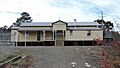
- The Stanthorpe Post Office, with its clock tower and fancy coat of arms, was built in 1901. It was designed by John Smith Murdoch, one of Australia's first government architects.
.jpg)

Stanthorpe's Role in Health
The cool, dry climate of Stanthorpe was thought to be good for health, especially for people with chest problems. After the First World War, many soldiers who had been exposed to mustard gas came to Stanthorpe to recover. These Soldier Settlers were given land around Stanthorpe. That's why some areas near Stanthorpe are named after famous First World War battlefields.
Modern Developments
- Stanthorpe State High School opened on January 23, 1961.
- The Stanthorpe Regional Art Gallery was created in 1972.
- The Stanthorpe Library opened in 1987 and was updated in 2004.
- The College of Wine Tourism opened in 2007.
Who Lives in Stanthorpe?
In 2016, Stanthorpe had a population of 5,406 people. By 2021, the population was 5,286 people.
Historic Places to See
Stanthorpe has several places that are listed for their historical importance. These "heritage-listed" sites show the town's rich past.


Some of these include:
- El Arish (a house)
- Masel Residence (another house)
- Central Hotel
- Stanthorpe Post Office
- Sundown Tin and Copper Mine
- Stanthorpe Soldiers Memorial
- Quart Pot Creek Rail Bridge
- Cherry Gully Tunnel (part of the railway line)
Learning in Stanthorpe
Stanthorpe has several schools and even a college focused on wine and tourism.
- Stanthorpe State School is a government primary school for students from Early Childhood to Year 6. It also has a special education program.
- St Joseph's Catholic School is a private school that teaches students from Prep (kindergarten) all the way to Year 12.
- Stanthorpe State High School is a government high school for students in Years 7 to 12. It also offers a special education program.

- Queensland College of Wine Tourism offers university-level degrees. It works with Stanthorpe State High School and other schools to provide training in the wine and tourism industries.
Things to Do and See
Stanthorpe has a library, an art gallery, and beautiful parks.
- The Stanthorpe Library and Regional Art Gallery building is located on Lock Street, next to Weeroona Park.

- The Stanthorpe Regional Art Gallery often changes its exhibitions. It has artworks by famous Australian artists like William Robinson and Margaret Olley. The "Stanthorpe Art Prize" competition happens every two years and attracts artists from all over Australia.

- The Southern Downs Regional Council has its offices and the Stanthorpe Civic Centre Complex in Marsh Street.
- There are lovely parks along both sides of Quart Pot Creek, with paths for walking and cycling.
Stanthorpe Heritage Museum
The Stanthorpe Heritage Museum is a great place to learn about the district's history. It has several old buildings that have been moved to the museum site. These include:
- A shepherd's hut from Ballandean Station (built 1876)
- An old jail from Willsons Downfall (built 1876)
- The old North Maryland school residence (built 1894)
- The old Stanthorpe Shire Council Chambers (built in 1914)
- Ardmore House, a summer holiday house (built 1920)
- Heath House, a residence (built 1940)


You can also find private art galleries and interesting street art around Stanthorpe.

Fun Events in Stanthorpe
Stanthorpe hosts many local events throughout the year:
- The annual Australian Small Winemakers Show
- The biennial Apple & Grape Harvest Festival (happens every two years)
- Ballandean Estates' Opera in the Vineyard
- The Stanthorpe Show
Getting Around Stanthorpe
Trains
Stanthorpe is on the Southern railway line. While there are no regular passenger trains, a tourist steam train called the Downs Explorer (formerly Southern Downs Steam Railway) runs most months from Warwick to Wallangarra, stopping in Stanthorpe.

Airport
The Stanthorpe Airport is located in Applethorpe. It's a public airport managed by the Southern Downs Regional Council, but it doesn't have regular scheduled flights.
Media and News
Stanthorpe has several radio stations and a local newspaper.
- Rebel FM (97.1 MHz) plays new and classic rock music.
- The Breeze (90.1 MHz) plays easy adult contemporary and classic hits.
- Ten FM (98.7 MHz) is a local community radio station with a focus on local news and programs, including "Italoz," a weekly program for the many listeners with Italian backgrounds.
- 3ABN Australia (88.0 MHz) is a Christian radio network with programs about health, lifestyle, and children.
- The Border Post is the local newspaper that covers news and events in the Stanthorpe area.
Sports in Stanthorpe
Stanthorpe has a strong love for European football (soccer) and supports many teams for its size. Several teams share home grounds due to the town's size.
| Club | A-Grade | Colts | Womens | Home Ground |
|---|---|---|---|---|
| Stanthorpe International Football Club | Yes | Yes | Yes | International Football Club |
| Stanthorpe United Redbacks Football Club | Yes | Yes | Yes | International Football Club |
| Stanthorpe Carlton United Football Club | Yes | Yes | Yes | C.F White Oval |
| Tenterfield Football Club | Yes | Yes | Yes | Rugby League Park |
| Ballandean Football Club | Yes | Yes | Yes | Ballandean Football Club |
| Stanthorpe City Football Club | Yes | Yes | Yes | C.F White Oval |
Stanthorpe's Climate
Because it's high up, Stanthorpe has a subtropical highland climate. This means it has warm summers and cool winters. As mentioned before, Stanthorpe holds the record for the coldest temperature ever recorded in Queensland, at -10.6 °C (12.9 °F) on June 23, 1961.
Sometimes, Stanthorpe even gets sleet and light snow! On July 17, 2015, there was a significant snowfall, with up to 8 centimetres (3.1 inches) falling in Stanthorpe and nearby areas.
Famous People from Stanthorpe
Many notable people have connections to Stanthorpe:
- Ben Armbruster - Olympic Swimmer who has represented Australia in the Commonwealth games, and will again represent Australia in the 2024 Paris Summer Olympics
- Jordan Atkins – a rugby league player
- John Bathersby – a former Roman Catholic Archbishop
- James Blundell – a country music singer
- Ben Dark – a television presenter
- Jerome Davidi – a Roman Catholic Priest who helped start the fruit industry in the Granite Belt
- Jack Drake – a bush poet
- Michael Hancock – a former rugby league footballer
- Edith Elizabeth Harslett – a successful soldier settler and active community member
- Ann Leahy – a politician
- Billy Moore – a former rugby league footballer
- John Reeves – a politician and judge
- Greg Ritchie – an Australian Test and one-day international cricketer
- Di Thorley – a politician
Images for kids
-
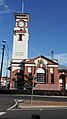
Stanthorpe Post Office, 2015
-
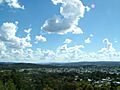
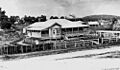
South-West aspect of Stanthorpe Township as seen from Mt Marlay
-
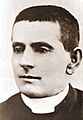
Father Jerome Davadi, promoter of wine growing in the Stanthorpe area
-
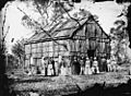
Wedding at Stanthorpe's Presbyterian Church, December 1872
-
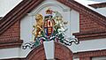
Coat of arms, Stanthorpe Post Office, 2015
-
El Arish house and gardens
-
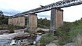
Quart Pot Creek Rail Bridge, 2015
-
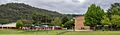
Stanthorpe State High School, 2023
-
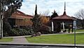
Stanthorpe library and art gallery, 2015, operated by the Southern Downs Regional Council
-
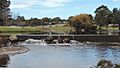
Park around Quart Pot Creek, 2015
-
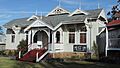
Old Stanthorpe Shire Council Chambers. Built in 1914, now part of the Stanthorpe Heritage Museum
-
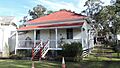
North Maryvale School Residence
-
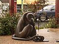
The Brass monkey at Stanthorpe's central Post Office Square
-
Stanthorpe railway station, 2015
