
Granite Belt facts for kids
Quick facts for kids Granite BeltQueensland |
|
|---|---|

The town of Stanthorpe
|
|
| LGA(s) | Southern Downs Region |
| State electorate(s) | Southern Downs |
| Federal Division(s) | Maranoa |
The Granite Belt is a special area in Australia, located in the Great Dividing Range. It stretches across parts of Queensland and New South Wales. This region is known for its cool weather and beautiful landscapes. The town of Stanthorpe is right in the middle of the Granite Belt.
The name "Granite Belt" comes from the many granite rocks found here. These rocks make the area look different from other parts of South East Queensland. The Granite Belt is famous for its amazing flowers and for growing almost all of Queensland's apples. Farmers here grow millions of apple trees!
The Granite Belt is also part of the larger Southern Downs region. The main river in this area is the Condamine River, which flows into the big Murray River.
Contents
Weather and Seasons
The Granite Belt has a unique climate because it's so high up. It's the coldest part of Queensland! This high elevation means the region experiences four clear seasons, unlike many other parts of Queensland.
The cool weather is perfect for growing fruits like grapes, apples, and stone fruits. However, sometimes hail can be a problem. Winters can be very cold, and frost is common at night. Sometimes, on rare occasions, it even snows! The area has seen snowfalls in 1984, 2007, and 2015.
Being between 680 metres (2,230 feet) and 1,200 metres (3,940 feet) above sea level makes the climate special. This high altitude helps create a cool contrast to the humid coastal areas, especially in summer.
Soils of the Granite Belt

The soil in the Granite Belt comes from the granite rocks found deep underground. These soils are usually sandy or clay-like on the surface. Deeper down, you'll find more clay or the original rock. This type of soil is good for the fruits and plants that grow here.
Towns and Villages
Many small towns and villages are part of the Granite Belt. In the north, you'll find Dalveen. Other villages include Applethorpe, Amiens, Ballandean, Glen Aplin, Passchendaele, Thulimbah, Pozieres, and Wallangarra. Wallangarra is right on the border with New South Wales. Liston is a small village in New South Wales that is also considered part of this region.
Fun Things to Do
The Granite Belt is a popular place for tourists, especially those looking for a short trip from South East Queensland and northern New South Wales. It's a great spot for nature lovers and foodies!
Wineries and Local Produce
The region is famous for its more than 50 wineries. It's Queensland's top wine region! Many wineries here have had great success with different types of grapes like Shiraz, Cabernet Sauvignon, Merlot, and Chardonnay. Recently, Verdelho grapes have also done very well. Some wineries are even trying out new grape varieties like Nebbiolo and Sangiovese.
Besides wine, the area has many restaurants and places to stay. If you're looking for work, there's often a demand for fruit and vegetable pickers from November to May.
National Parks and Nature

The Granite Belt is home to several beautiful national parks. These include Girraween, Bald Rock, Sundown, and Boonoo Boonoo.
- Girraween National Park: This park is known for its amazing granite rock formations, like "The Pyramids." The name 'Girraween' means "place of flowers" in the local Aboriginal language. In spring, the wildflowers here are incredible, with over 800 different kinds of flowering plants! You can see ground orchids, rock roses, pea-flowers, and native bluebells.
- Bald Rock National Park: This park features the massive Bald Rock, a huge granite dome.
- Boonoo Boonoo National Park: Located further east, this park also has beautiful natural features.
- Sundown National Park: Found to the west, this park offers more rugged landscapes.
The granite boulders in the region are popular for rock climbing, and many people enjoy bushwalking to explore places like the "Underground River."
Another exciting thing for tourists is the chance to see snow on the ground in Queensland, which is a rare sight!
History of the Granite Belt

The Granite Belt was first home to the Githabul peoples, who lived here for thousands of years. European exploration began in 1827 when Allan Cunningham explored the area. Places like Cunninghams Gap and the Cunningham Highway are named after him.
In the mid-1800s, large sheep and cattle farms called "pastoral stations" were set up. Later, people discovered gold, copper, and tin in the area, which brought more European settlers.
The railway reached Stanthorpe in 1881 and then extended to the New South Wales border in 1887, leading to the creation of Wallangarra.
After World War I, some land in the Granite Belt was given to soldiers who returned from the war. Because of this, many rural areas are named after famous battles in France, like Amiens and Pozieres. While these places were once busy, many families eventually left, and today, only small primary schools or just the names remain.
The first wine grapes in the region were planted in 1965, starting the Granite Belt's journey to becoming a famous wine region.
Images for kids
-
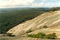
The massive Bald Rock in Bald Rock National Park.

