
Condamine River facts for kids
Quick facts for kids Condamine |
|
|---|---|

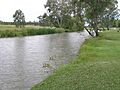
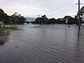
Condamine River, Warwick, 2009
|
|

Location of Condamine River mouth in Queensland
|
|
| Country | Australia |
| State | Queensland |
| Regions | Darling Downs, South West Queensland |
| Settlements | Killarney, Warwick |
| Physical characteristics | |
| Main source | Mount Superbus below The Head, near Main Range National Park 772 m (2,533 ft) 28°14′42″S 152°28′21″E / 28.24500°S 152.47250°E |
| River mouth | confluence with the Dogwood Creek to form the Balonne River between Surat and Condamine 256 m (840 ft) 27°03′20″S 149°37′37″E / 27.05556°S 149.62694°E |
| Length | 657 km (408 mi) |
| Basin features | |
| River system | Balonne catchment, Murray-Darling basin |
| Basin size | 13,292 km2 (5,132 sq mi) |
| Tributaries |
|
| Reservoirs and weirs | Talgai Weir, Yarramalong Weir, Lemon Tree Weir, Loudoun Weir, Tipton Weir, Cecil Plains Weir |
The Condamine River is an important river in Queensland, Australia. It is part of the larger Murray-Darling Basin river system. This river helps drain the northern part of the Darling Downs region.
The Condamine River is about 657 kilometers (408 miles) long. It starts high up on Mount Superbus, which is the tallest peak in South East Queensland. This mountain is on the western side of the Great Dividing Range. From there, the river flows northwest across the Darling Downs and then turns west. Eventually, the Condamine River becomes part of the Balonne River, which is a tributary of the Darling River.
Contents
River's Journey and Features

The Condamine River begins its journey on the slopes of Mount Superbus. It then flows through a beautiful area called Cambanoora Gorge. As it continues, the river passes through several towns. These include Killarney, Warwick, and Chinchilla. A smaller stream called Gowrie Creek also joins the Condamine. This creek drains the areas around Toowoomba.
Near the town of Surat, the Condamine River changes its name. It turns southwest and becomes known as the Balonne River. The Condamine River drops about 516 meters (1,693 feet) over its long course. Its catchment area covers a huge space of 13,292 square kilometers (5,132 square miles). This area is home to more than 1,800 wetlands.
The Balonne River splits into different branches further downstream. One branch is called the Culgoa River. This river eventually flows into the Darling River. Another branch of the Balonne River also splits. It forms the Bokhara River and the Narran River. These rivers then join the Barwon River west of Brewarrina. The Barwon River also flows into the Darling River. Towns along the Balonne River include St George, Dirranbandi, and Surat.
Storing Water for Use

Water from the Condamine River is very important. It is used to supply drinking water to towns. It also helps farmers water their crops through irrigation. Leslie Dam is a major water storage area. It is built on Sandy Creek, which flows into the Condamine. This dam provides most of the water for Warwick.
There are also several smaller structures called weirs along the river. These weirs help hold back water. Some of these include Talgai Weir, Yarramalong Weir, Lemon Tree Weir, Loudoun Weir, Tipton Weir, and Cecil Plains Weir. During times of drought, the Condamine River can become very low. It sometimes turns into a series of small, drying ponds.
Chinchilla Weir
The Chinchilla Weir was built in 1973. It is located on the Condamine River, about eight kilometers (5 miles) south of Chinchilla. This weir has two main purposes. It provides water for irrigation to farms along the river. It also helps supply water to the town of Chinchilla.
The Chinchilla Weir is made of earth and concrete. It is known for its unique curved wall design. This weir is the only water storage for the Chinchilla Weir Water Supply Scheme. When it officially opened in 1974, about 5,000 people visited. Today, Chinchilla Weir is a popular spot for fun activities. People enjoy waterskiing, canoeing, swimming, and fishing there.
River's History
Parts of the Condamine River area were originally home to the Bundjalung people. The river was named in 1827 by a botanist named Allan Cunningham. He named it after Thomas de la Condamine. Thomas de la Condamine was an important person who worked for Governor Ralph Darling.
Patrick Leslie was one of the first European settlers in this area. He started a large farm called Canning Downs in 1840, near Warwick. Major Thomas Mitchell crossed the Balonne River in 1846. The next year, in 1847, Ludwig Leichhardt explored the Condamine River.


In 1985, there was a plan to move water from the Clarence River to the Condamine River basin. The Condamine River and its surrounding areas were affected by the 2010–11 Queensland floods. During these floods, the river reached very high levels. At the town of Condamine, it peaked at 15.25 meters (50 feet).
Natural Gas and the River
Around the year 2000, companies started looking for natural gas in the Chinchilla region. This is where the Condamine River flows. This type of gas is found in layers of coal deep underground. It is often called "coal seam gas."
To get this gas, water needs to be removed from the coal layers. This allows the gas to flow out. Sometimes, removing this water can affect underground water sources. People who have water bores (wells) on their land might find less water or even gas in their bores. In Queensland, gas companies must fix any problems they cause to a landholder's water supply.
Methane Gas Bubbles
In 2012, people noticed methane gas bubbling up from the Condamine River. Scientists believe this gas comes from natural rock layers deep below the river. The Queensland Government investigated these gas bubbles. Their study suggested that the bubbling was likely not caused by gas extraction activities nearby. However, they said more studies were needed. The report also stated that the gas seeps did not pose a safety risk or harm the environment in the immediate area.
In 2016, the gas seeps gained more attention. A politician named Jeremy Buckingham filmed himself lighting the gas bubbles on fire. He suggested that a process called "hydraulic fracturing" might be the cause. However, there has been no direct link proven between this process and the bubbles.
In 2017, scientists from CSIRO studied the Condamine River. They looked at why methane gas was escaping. They concluded that there could be several reasons for the methane releases. They also noted that natural gas seeps are not uncommon in Queensland. However, there were no previous records of bubbles appearing in a river.
The gas company that operates in the area reported a big drop in the amount of gas bubbling from the river in 2017. They said they achieved this by collecting the gas underground before it could reach the river. This helps to reduce the natural gas seeps.
Images for kids
-
Condamine River, Warwick, 2009
-
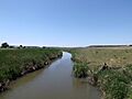
Hodgson Creek at Felton, 2014
-
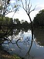
The Condamine River near Chinchilla in 2012
-
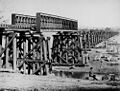
Railway bridge construction at Warwick, 1882
-
Flooded Victoria Street, Warwick, 2010
