Macalister, Queensland facts for kids
Quick facts for kids MacalisterQueensland |
|||||||||||||||
|---|---|---|---|---|---|---|---|---|---|---|---|---|---|---|---|

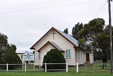
Reedeemer Lutheran Church
|
|||||||||||||||
| Population | 156 (2021 census) | ||||||||||||||
| • Density | 0.4766/km2 (1.234/sq mi) | ||||||||||||||
| Postcode(s) | 4406 | ||||||||||||||
| Area | 327.3 km2 (126.4 sq mi) | ||||||||||||||
| Time zone | AEST (UTC+10:00) | ||||||||||||||
| Location | |||||||||||||||
| LGA(s) | Western Downs Region | ||||||||||||||
| State electorate(s) | Warrego | ||||||||||||||
| Federal Division(s) | Maranoa | ||||||||||||||
|
|||||||||||||||
Macalister is a small town in Queensland, Australia. It's located in a rural area called the Western Downs Region. In 2021, about 156 people lived there.
Contents
Where is Macalister?
Macalister is part of a larger area known as the Darling Downs. The town itself is right in the middle of this area.
A main road called the Warrego Highway goes through Macalister. It comes from Dalby in the south-east and continues towards Warra in the north-west.
The Western railway line runs right next to the highway. There were once three railway stations in the area:
- Broadmead railway station, which is now closed.
- Macalister railway station, which served the town.
- Apunyal railway station, which is also closed.
Because of these old railway stations, there are two small areas within Macalister:
- Broadmead, in the north-west.
- Apunyal, in the south-east.
A Look at Macalister's Past
The town of Macalister is named after Arthur Macalister. He was a very important person who served as the Premier of Queensland from 1866 to 1867. A Premier is like a leader of a state government.
The name Apunyal comes from an Aboriginal word. It means large plain, which describes the flat land in the area.
The Macalister Post Office opened a long time ago, on 1 July 1880. Before that, there was a smaller mail service called a receiving office from 1876. The post office closed in 1980.
There were also a couple of schools in the area over the years:
- Ranges Bridge Provisional School opened around 1886. It closed in 1894, and its building was moved to become Macalister Provisional School.
- Macalister Provisional School opened on 27 August 1894. It later became Macalister State School in 1909. In 1913, it was renamed Apunyal State School and closed around 1935.
- A second Macalister State School opened in 1913. This school closed on 4 May 1973.
Who Lives in Macalister?
The number of people living in Macalister has changed over the years:
- In 2006, about 486 people lived in Macalister and the surrounding area.
- By 2016, the population was 153 people.
- In 2021, the population grew slightly to 156 people.
Learning in Macalister
There are no schools directly in Macalister today. Kids living here usually go to primary schools in nearby towns like Jimbour East, Warra, Dalby, or Kogan.
For high school, students might go to Jandowae State School, which goes up to Year 10. For all high school years (up to Year 12), students can attend Dalby State High School in Dalby.
Places to Visit
- The Redeemer Lutheran Church is a local church located on the Warrego Highway.
- The Macalister branch of the Queensland Country Women's Association (QCWA) meets at the QCWA Hall. The QCWA is a group that supports women and communities in rural areas.
 | William M. Jackson |
 | Juan E. Gilbert |
 | Neil deGrasse Tyson |


