
Wallangarra, Queensland facts for kids
Quick facts for kids WallangarraQueensland |
|||||||||||||||
|---|---|---|---|---|---|---|---|---|---|---|---|---|---|---|---|
.JPG)
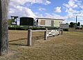
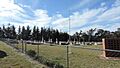
Border "gates" at Wallangarra
|
|||||||||||||||

Wallangarra
Location in Queensland
|
|||||||||||||||
| Population | 440 (2021 census) | ||||||||||||||
| • Density | 11.92/km2 (30.9/sq mi) | ||||||||||||||
| Established | 1885 | ||||||||||||||
| Postcode(s) | 4383 | ||||||||||||||
| Elevation | 878 m (2,881 ft) | ||||||||||||||
| Area | 36.9 km2 (14.2 sq mi) | ||||||||||||||
| Time zone | AEST (UTC+10:00) | ||||||||||||||
| LGA(s) | Southern Downs Region | ||||||||||||||
| County | Bentinck | ||||||||||||||
| Parish | Tenterfield | ||||||||||||||
| State electorate(s) | Southern Downs | ||||||||||||||
| Federal Division(s) | Maranoa | ||||||||||||||
|
|||||||||||||||
|
|||||||||||||||
Wallangarra is a small town and area in the Southern Downs Region of Queensland, Australia. It sits right on the border with New South Wales. It is one of the most southerly towns in Queensland, located about 258 kilometres (160 miles) southwest of Brisbane. Wallangarra is on the Queensland side of the border, and the town of Jennings is on the New South Wales side.
In 2021, about 440 people lived in Wallangarra.
Contents
Exploring Wallangarra's Past
How Wallangarra Began

In 1885, the Queensland Government decided to create a town where the railway lines from Queensland and New South Wales would meet. This was important because the two states used different railway track widths. Queensland used a "narrow gauge" (1.067 metres or 3 feet 6 inches), while New South Wales used a "standard gauge" (1.435 metres or 4 feet 8.5 inches). This difference is called a break-of-gauge.
The town was planned so that goods and passengers could switch trains at the border. On June 29, 1885, land was sold for the new town. Two railway stations were built. One was named Wallan-garra railway station, and the town took its name from it, but spelled it Wallangarra. The other station, Bald Mountain, is now no longer used.
School Days in Wallangarra
Wallangarra Provisional School first opened its doors on February 13, 1888. It later became Wallangarra State School on January 1, 1909.
Border Control During the Flu

In 1919, during the Spanish flu pandemic, the Queensland Government set up strict rules at the Wallangarra border. This was to stop the flu from spreading into Queensland. Police checked people crossing the border to make sure it was safe for Queensland residents to return home.
The Railway's Changing Role
The railway at Wallangarra was the only train link between Queensland and New South Wales for many years. However, in 1930, a new standard gauge track was finished further south, which included a bridge over the Clarence River at Grafton. After this, Wallangarra's railway station became less important.
Regular train services stopped in 1997. But in 2003, after being fixed up, the station reopened as a museum. Sometimes, old steam trains still bring tourists to Wallangarra from Stanthorpe.
Local Businesses and Industry
The Anderson Meat Packing Company was a big business in Wallangarra. It reopened in 1938 and operated a large beef abattoir (meat processing plant) until 1982. It employed over 400 people. The plant was built on the border to use train lines from both Queensland and New South Wales.
Later, Riverina Stock Feeds also had a packing plant near the railway station until 1995.
Around 2005, Thomas Foods International opened a large mutton (sheep meat) processing plant near the town. Most of the mutton produced there was Halal and sent to other countries. However, this plant closed in 2016 due to low animal numbers and tough trading conditions.
Wallangarra During World War II
During World War II, the Australian Government built an army store on the Queensland side of the border. They also built an ammunition dump (where weapons and explosives are stored) on the New South Wales side. Special train tracks were built to reach these stores. Trucks and supplies moved through the town day and night during the war.
Community Places and Changes
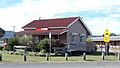
Wallangarra Cemetery was created in 1953. St Gabrielle's Anglican Church was opened in 1964 but closed around 2013. The building was later sold.
Wallangarra's Location and Landscape
Wallangarra is located in a valley between two mountain ranges. These ranges are part of the larger Great Dividing Range. The town is about 878 metres (2,881 feet) above sea level. A natural gap in the mountains north of Wallangarra made it an important crossing point for the New England Highway and the first railway line between Brisbane and Sydney. The area is also known for its New England Peppermint Grassy Woodland.
Wallangarra's Weather

Wallangarra is known as the coldest town in Queensland when looking at average maximum temperatures. This is because it's high up and far south in the state. In winter, the average high temperature is about 13.9°C (57°F), and in summer, it's around 26.6°C (80°F). Wallangarra holds the record for Queensland's lowest ever maximum temperature: 2.4°C (36.3°F) on July 3, 1984.
Even though it gets cold, the lowest temperatures aren't always extreme. Other towns at lower altitudes, like Warwick and Oakey, often record colder minimum temperatures. Stanthorpe, which is at a similar height but flatter, has warmer days and less snow than Wallangarra.
| Climate data for Wallangarra Post Office (1938–1992, rainfall 1888–2024); 875 m AMSL; 28.92° S, 151.93° E | |||||||||||||
|---|---|---|---|---|---|---|---|---|---|---|---|---|---|
| Month | Jan | Feb | Mar | Apr | May | Jun | Jul | Aug | Sep | Oct | Nov | Dec | Year |
| Record high °C (°F) | 36.2 (97.2) |
34.3 (93.7) |
31.7 (89.1) |
34.5 (94.1) |
24.5 (76.1) |
20.7 (69.3) |
20.4 (68.7) |
25.9 (78.6) |
28.1 (82.6) |
32.6 (90.7) |
35.0 (95.0) |
36.0 (96.8) |
36.2 (97.2) |
| Mean daily maximum °C (°F) | 26.6 (79.9) |
25.4 (77.7) |
24.1 (75.4) |
21.1 (70.0) |
17.5 (63.5) |
14.5 (58.1) |
13.9 (57.0) |
15.3 (59.5) |
18.4 (65.1) |
21.5 (70.7) |
24.3 (75.7) |
26.6 (79.9) |
20.8 (69.4) |
| Mean daily minimum °C (°F) | 14.7 (58.5) |
14.7 (58.5) |
13.1 (55.6) |
9.3 (48.7) |
5.7 (42.3) |
3.0 (37.4) |
2.0 (35.6) |
2.7 (36.9) |
5.2 (41.4) |
8.3 (46.9) |
11.0 (51.8) |
13.3 (55.9) |
8.6 (47.5) |
| Record low °C (°F) | 7.7 (45.9) |
6.1 (43.0) |
3.0 (37.4) |
−1.5 (29.3) |
−3.7 (25.3) |
−5.6 (21.9) |
−5.1 (22.8) |
−4.5 (23.9) |
−3.7 (25.3) |
−2.7 (27.1) |
1.7 (35.1) |
5.4 (41.7) |
−5.6 (21.9) |
| Average rainfall mm (inches) | 99.7 (3.93) |
82.9 (3.26) |
72.2 (2.84) |
38.4 (1.51) |
44.8 (1.76) |
46.3 (1.82) |
49.0 (1.93) |
40.9 (1.61) |
47.8 (1.88) |
75.0 (2.95) |
79.2 (3.12) |
100.2 (3.94) |
774.9 (30.51) |
| Average rainy days (≥ 1.0 mm) | 7.1 | 6.5 | 6.1 | 4.1 | 4.6 | 5.0 | 5.0 | 4.7 | 5.0 | 6.2 | 6.6 | 7.4 | 68.3 |
| Source: Bureau of Meteorology | |||||||||||||
Wallangarra Today
Education Opportunities
Wallangarra State School is a primary school for students from Prep to Year 6. It is located at 50 Callandoon Street. In 2018, the school had 76 students. There isn't a high school in Wallangarra. The closest government high school is Stanthorpe State High School in Stanthorpe.
Local Facilities and Services

The Wallangarra Cemetery is on McCall Street. The Wallangarra branch of the Queensland Country Women's Association (QCWA) has its rooms on Rockwell Street. The Wallangarra Union Church is also on Rockwell Street.
Things to See and Do
Wallangarra is part of the beautiful Granite Belt region. It is close to Sundown National Park to the west and Girraween National Park to the east, both great places for outdoor adventures.
Beehive Dam is about 5 kilometres (3 miles) north of town. It's a popular spot for fishing, as it's stocked with fish like golden perch, Murray cod, and silver perch.
Famous People from Wallangarra
Rugby league star Billy Moore lived in Wallangarra when he was a child. He is well-known for playing for the North Sydney Bears and the Queensland State of Origin team. He was born in Tenterfield, New South Wales, which had the closest hospital.
Images for kids
-
Border "gates" at Wallangarra
-
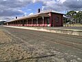
Wallangarra station with different style of awnings and the Queensland side compared to the New South Wales side
-
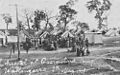
Influenza quarantine camp, Wallangarra, 1919
-
Climate data is recorded at the Wallangarra Post Office
-
Wallangarra cemetery, 2015
