Grafton, New South Wales facts for kids
Quick facts for kids GraftonNew South Wales |
|||||||||
|---|---|---|---|---|---|---|---|---|---|
|
(From left to right)
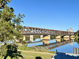
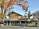
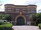
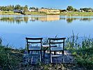
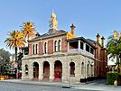
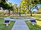
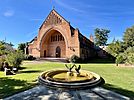
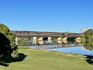
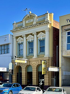
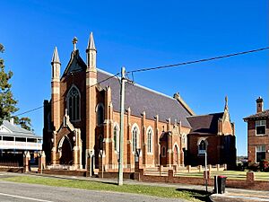
Grafton Bridge from North Bank Grafton Court House, Grafton Gaol Clarence River, Grafton Post Office Market Square, Christ Church Cathedral |
|||||||||
| Population | 19,255 (2021) | ||||||||
| Established | 1851 | ||||||||
| Postcode(s) | 2460 | ||||||||
| Elevation | 5 m (16 ft) | ||||||||
| Location |
|
||||||||
| LGA(s) | Clarence Valley Council | ||||||||
| Region | Northern Rivers | ||||||||
| County | Clarence | ||||||||
| State electorate(s) | Clarence | ||||||||
| Federal Division(s) | Page | ||||||||
|
|||||||||
Grafton, also known by its traditional name Gumbin Gir in the Bundjalung-Yugambeh language, is a city in the Northern Rivers area of New South Wales, Australia. It sits on the Clarence River, which is a wide, flat area of land called a floodplain. Grafton is about 608 kilometers (378 miles) north-northeast of Sydney, the state capital.
The big cities closest to Grafton are Brisbane and the Gold Coast, which are just across the border in South East Queensland. In 2021, Grafton had a population of 19,255 people. It is the largest town and a main administrative center for the Clarence Valley Council. This local government area is home to over 50,000 people.
Contents
History of Grafton
Before Europeans arrived, the Clarence River was the boundary between the Bundjalung and Gumbaynggirr Indigenous peoples. Today, many descendants of both groups live in the Grafton area.
Grafton first became a European settlement because of "cedar-getters." These were people who cut down valuable cedar trees. In 1831, an escaped prisoner named Richard Craig explored the area. He found so much cedar that he was pardoned and given money to bring more cedar-getters to the region. News of this valuable resource spread quickly. In 1838, a pioneer named John Small was one of the first to settle on Woodford Island. Soon after, the area that would become Grafton was established.
In 1851, Governor FitzRoy officially named the town Grafton. He named it after his grandfather, the Duke of Grafton, who was once the Prime Minister of the United Kingdom. Grafton officially became a city in 1885. Today, local industries include cutting timber, raising beef cattle, fishing, prawning, growing sugar, making things, and tourism.
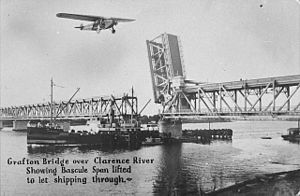
The Grafton Bridge, which connects Grafton with South Grafton, opened in 1932. This bridge was very important because it completed the railway line between Sydney and Brisbane. It also became a key part of the Pacific Highway. Before the bridge, people had to use a ferry to travel between Grafton and South Grafton. Because of this, South Grafton grew to have its own unique identity. It even had its own local government from 1896 to 1956.
Important Historic Places
Grafton has several places that are listed for their historical importance. These include:
- Duke Street: Christ Church Cathedral
- 170 Hoof Street: Grafton Correctional Centre (the old jail)
- North Coast railway: Grafton Bridge
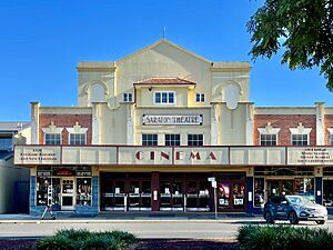
- 95 Prince Street: Saraton Theatre
- 150 Victoria Street: Arcola, Grafton
Grafton's Population
| Historical population | ||
|---|---|---|
| Year | Pop. | ±% |
| 1921 | 6,358 | — |
| 1933 | 8,551 | +34.5% |
| 1947 | 12,025 | +40.6% |
| 1954 | 13,365 | +11.1% |
| 1961 | 15,526 | +16.2% |
| 1966 | 15,987 | +3.0% |
| 1971 | 16,387 | +2.5% |
| 1976 | 16,516 | +0.8% |
| 1981 | 17,005 | +3.0% |
| 1986 | 16,647 | −2.1% |
| 1991 | 16,642 | −0.0% |
| 1996 | 16,562 | −0.5% |
| 2001 | 17,380 | +4.9% |
| 2006 | 17,501 | +0.7% |
| 2011 | 16,598 | −5.2% |
| 2016 | 16,787 | +1.1% |
| 2021 | 17,155 | +2.2% |
| Source: Australian Bureau of Statistics data. | ||

In the 2021 census, Grafton had 19,255 people living there.
Here are some facts about the people in Grafton from that census:
- About 10.4% of Grafton's population are Aboriginal and Torres Strait Islander people.
- Most people (87.1%) were born in Australia. The next most common birthplaces were England (1.4%) and New Zealand (0.7%).
- About 90.5% of people spoke only English at home.
- When asked about religion, the most common answers were No Religion (37.8%), Anglican (20.9%), and Catholic (18.2%).
Grafton's Weather
Grafton has a humid subtropical climate. This means it has hot, wet summers and mild winters. It rains much more in summer than in winter. Sometimes, a month can get over 300 millimeters (12 inches) of rain. However, during dry periods, rainfall can be very low. For example, in August 2017, only 0.2 millimeters (0.008 inches) of rain fell. Grafton usually has about 115 clear days each year.
Like many towns in New South Wales, Grafton can experience heatwaves in the summer. On February 12, 2017, Grafton recorded its highest temperature ever: 46.3 °C (115.3 °F). This was the hottest day since records began in 1966. In winter, the temperature can change a lot between day and night.
| Climate data for Grafton Airport AWS (2006–2022) | |||||||||||||
|---|---|---|---|---|---|---|---|---|---|---|---|---|---|
| Month | Jan | Feb | Mar | Apr | May | Jun | Jul | Aug | Sep | Oct | Nov | Dec | Year |
| Record high °C (°F) | 41.3 (106.3) |
45.8 (114.4) |
37.2 (99.0) |
32.4 (90.3) |
29.6 (85.3) |
29.7 (85.5) |
27.7 (81.9) |
36.3 (97.3) |
38.3 (100.9) |
38.9 (102.0) |
42.8 (109.0) |
41.3 (106.3) |
45.8 (114.4) |
| Mean daily maximum °C (°F) | 30.3 (86.5) |
29.6 (85.3) |
28.1 (82.6) |
25.7 (78.3) |
23.2 (73.8) |
20.6 (69.1) |
20.6 (69.1) |
22.5 (72.5) |
24.8 (76.6) |
26.7 (80.1) |
28.5 (83.3) |
29.2 (84.6) |
25.8 (78.5) |
| Mean daily minimum °C (°F) | 19.0 (66.2) |
18.9 (66.0) |
17.6 (63.7) |
13.8 (56.8) |
9.6 (49.3) |
7.1 (44.8) |
5.4 (41.7) |
5.9 (42.6) |
9.7 (49.5) |
12.9 (55.2) |
15.8 (60.4) |
17.5 (63.5) |
12.8 (55.0) |
| Record low °C (°F) | 10.8 (51.4) |
13.4 (56.1) |
9.6 (49.3) |
0.4 (32.7) |
−1.5 (29.3) |
−1.8 (28.8) |
−3.4 (25.9) |
−2.8 (27.0) |
0.1 (32.2) |
3.2 (37.8) |
6.0 (42.8) |
8.6 (47.5) |
−3.4 (25.9) |
| Average rainfall mm (inches) | 122.4 (4.82) |
177.9 (7.00) |
180.2 (7.09) |
84.8 (3.34) |
72.9 (2.87) |
83.0 (3.27) |
32.1 (1.26) |
55.3 (2.18) |
50.6 (1.99) |
74.9 (2.95) |
101.4 (3.99) |
117.1 (4.61) |
1,175.2 (46.27) |
| Average rainy days (≥ 1.0 mm) | 10.4 | 10.9 | 11.2 | 8.0 | 7.5 | 5.8 | 4.6 | 4.3 | 5.2 | 7.2 | 9.2 | 10.2 | 94.5 |
| Average afternoon relative humidity (%) | 56 | 60 | 59 | 57 | 57 | 54 | 49 | 43 | 44 | 49 | 52 | 54 | 53 |
| Average dew point °C (°F) | 19.0 (66.2) |
19.3 (66.7) |
17.9 (64.2) |
15.2 (59.4) |
12.6 (54.7) |
9.8 (49.6) |
7.9 (46.2) |
7.2 (45.0) |
9.6 (49.3) |
12.8 (55.0) |
15.3 (59.5) |
17.8 (64.0) |
13.7 (56.7) |
| Source 1: Bureau of Meteorology | |||||||||||||
| Source 2: Bureau of Meteorology (Humidity from Grafton Olympic Pool, 1976–2010) | |||||||||||||
Grafton's Culture and Festivals
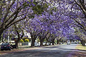
Grafton is famous as the "Jacaranda City." This is because of its many streets lined with Jacaranda trees and its yearly Jacaranda Festival. The festival started in 1935 and happens every October/November. There's even a half-day public holiday in Grafton on the first Thursday of November for the main festival day. During the 1963 festival, an inventor named John W. Dickenson showed off the first modern hang glider on the Clarence River. This was a big moment for the sport!
Another half-day public holiday is held for the Grafton Cup horse race. This race happens every year on the second Thursday in July. It's the highlight of the city's annual Racing Carnival, which lasts for two weeks. This carnival is Australia's biggest and richest outside of the major cities.
Grafton is also where several famous country music artists were born. Local artist Troy Cassar-Daley has won many awards. In 2006, he received four Golden Guitar awards at the Tamworth Country Music Festival. Samantha McClymont, who was the Grafton Jacaranda Queen in 2005/2006 and is the sister of Brooke McClymont, also won an award for her country music talent at the same event.
The beauty of Grafton's jacaranda trees in bloom is even mentioned in a popular Australian song. The band Cold Chisel sings about it in their song Flame Trees. One of the band members, Don Walker, lived in Grafton when he was younger.
Sports in Grafton
The most popular sport in Grafton is Rugby league. There are two local clubs in the Group 2 Rugby League competition: the Grafton Ghosts and their rivals, the South Grafton Rebels. Both clubs have a long history, and games between them can attract over 3,000 fans!
Other sports played in Grafton include soccer, Rugby union, Australian rules football, and Field Hockey.
Important Buildings
The Christ Church Cathedral was designed by John Horbury Hunt and finished in 1884. It is the main church for the Anglican Diocese of Grafton.
Schaeffer House is a historic home built in 1900. It now holds a collection from the Clarence River Historical Society, which started in 1931.
Getting Around Grafton
The Murwillumbah railway line reached Grafton in 1905. The North Coast Line from Sydney arrived at South Grafton's railway station in 1915. Before the combined road and rail bridge opened in 1932, a special train ferry connected the two railway lines. The Clarence Valley Regional Airport serves Grafton for air travel.
Until May 2020, the Pacific Highway, a major road connecting northern and southern Australia, went right through Grafton. It also connected Grafton to the Gwydir Highway, which is a main road going east to west.
Busways runs local bus routes in Grafton. They also have routes to nearby towns like Junction Hill, Jackadgery, Copmanhurst, Maclean, and Yamba.
Lawrence Bus Service offers a shopping bus and school services to and from Lawrence.
Northern Rivers Buslines has a weekday service to Lismore, passing through Maclean, Evans Head, and Coraki.
NSW TrainLink provides a bus service to Byron Bay that connects with the train from Sydney. They also have a bus service to Moree via Glen Innes, connecting with the train from Brisbane.
Industries in Grafton
From 1904 to 1917, the Grafton Copper Mining Company operated a copper mine, a metal-melting plant (smelter), and a tramway at Cangai. This was over 100 km from Grafton by river. Today, it's about 70 km by road. From 1952 to 1997, the Grafton brewery made Grafton Bitter beer for the North Coast. The nearby Harwood Mill is the oldest working sugar mill in New South Wales.
Newspapers, Radio, and TV
Newspapers
Grafton's daily online newspaper is The Daily Examiner, which is owned by News Corp Australia.
Radio Stations
- 2GF 89.5 FM (commercial)
- FM 104.7 (commercial)
- Triple J 91.5 FM/96.1 FM
- ABC Northern Rivers 738 AM/94.5 FM
- ABC Classic FM 97.9 FM/95.3 FM
- Radio National 99.5 FM/96.9 FM
- Sky Sports Radio Racing Radio 101.5 FM
- Life FM 103.1 (community)
- Raw FM 87.6
- Vision Christian Radio 1611 AM/88.0 FM
Television Channels
- Seven (formerly Prime7), 7HD, 7two, 7mate, 7Bravo, 7flix, ishop tv, Racing.com (owned by the Seven Network)
- Nine (NBN Television); 9HD, 9Gem, 9Gem HD, 9Go!, 9Life, Extra (owned by the Nine Network)
- 10, 10HD, 10 Bold Drama, 10 Peach Comedy, Sky News Regional, TVSN, Gold – (10 Northern NSW, owned by WIN Corporation)
- ABC Television including ABC, ABC Family, ABC Entertains and ABC News (part of the Australian Broadcasting Corporation)
- Special Broadcasting Service, SBS, SBS Viceland, SBS Food, SBS World Movies, SBS WorldWatch and NITV
You can also get Pay television services from Foxtel.
NBN (Channel 9) broadcasts a local news bulletin every night at 6:00 pm. Seven News also has a news bulletin for the mid-north coast on weekday evenings. WIN Television's WIN News provides short news updates throughout the day.
Schools in Grafton
Public Schools
- Copmanhurst Public School
- Gillwinga Public School
- Grafton High School
- Grafton Public School
- South Grafton High School
- South Grafton Public School
- Westlawn Public School
Independent Schools
- Clarence Valley Anglican School (formerly The Cathedral School)
- McAuley Catholic College
- St. Joseph's Primary School
- St. Mary's Primary School
- St. Andrew's Christian School
Famous People from Grafton
Many notable people were born or have lived in Grafton, including:
- James Armah (born 1976), a professional boxer.
- Troy Cassar-Daley (born 1969), a country musician.
- Peter Drysdale (born 1938), an economist.
- Gary Foley (born 1950), an Aboriginal activist and writer.
- Ernest Henry (1904–1998), an Olympic swimmer.
- Andrew Landenberger (born 1966), an Olympic sailor.
- Brent Livermore (born 1976), a field hockey player.
- The McClymonts, a country music group with sisters Brooke, Samantha, and Mollie.
- Tony Mundine (born 1951), a boxer.
- Warren Mundine (born 1956), a politician.
- Kevin Nichols (born 1955), a track cyclist.
- Sir Earle Page (1880–1961), who was the 11th Prime Minister of Australia.
- Ruby Payne-Scott (1912–1981), a pioneer in radio physics and radio astronomy.
- Frank Partridge (1924–1964), who received the Victoria Cross for bravery.
- Cameron Pilley (born 1982), a squash player.
- Tyrone Roberts (born 1991), a rugby league player.
- Henry Ernest Searle (1866–1889), a rower.
- Sir Grafton Elliot Smith (1871–1937), an anatomist.
- Don Walker (born 1951), a musician.
- Danny Wicks (born 1985), a rugby league player.
 | Misty Copeland |
 | Raven Wilkinson |
 | Debra Austin |
 | Aesha Ash |


