Maclean, New South Wales facts for kids
Quick facts for kids MacleanNew South Wales |
|
|---|---|

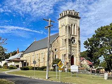
St Mary's Catholic Church
|
|
| Population | 2,778, The total urban area inc contiguous suburbs, Townsend & Gulmarrad (2463 postcode) is 8,304 (2021 census) |
| Postcode(s) | 2463 |
| Elevation | 9 m (30 ft) |
| Location | |
| LGA(s) | Clarence Valley Council |
| State electorate(s) | Clarence |
| Federal Division(s) | Page |
Maclean is a friendly town in the Northern Rivers area of New South Wales, Australia. It's located right on the Clarence River. Maclean is part of the Clarence Valley Council local government area.
In 2021, about 2,778 people lived in Maclean. If you include nearby areas like Townsend and Gulmarrad, the population is over 8,304. The wider Lower Clarence area, which includes Maclean, Yamba, and Iluka, has a combined population of over 17,500 people.
Maclean is known for its tourism, growing sugar cane, farming, and catching prawns from the river. It shares the job of being an administrative centre for the Clarence Valley Council with the city of Grafton.
Contents
Exploring Maclean's Geography
Maclean is tucked away at the bottom of Mt Maclean. It sits right on the edge of the Clarence River. The river splits around Woodford Island and then comes back together near Maclean. A bridge connects Maclean to Woodford Island, making it easy to visit.
Because of its location, Maclean can sometimes face floods when the river rises after heavy rain.
The main road, the Pacific Highway, used to go right through Maclean. But in 1966, a bypass was built to take traffic around the town. This bypass was made even bigger in 2020 with a new four-lane bridge.
Maclean's Interesting History
Who Lived Here First?
The land around Maclean was originally home to the Gumbaingirr or Yaygir Indigenous peoples. They lived here for thousands of years.
In 1799, a famous explorer named Matthew Flinders sailed near the mouth of the Clarence River. He didn't think much of the area at the time. Later, in the 1820s and 1830s, some escaped convicts passed through and reported seeing a "big river."
Early European Settlement
In 1838, Thomas Small sent a group of people from Sydney to cut down valuable red cedar trees. They sailed down the "big river," becoming the first ship to travel on it. Small settled on Woodford Island that same year.
The next year, Governor Sir George Gipps named the river the Clarence. He named it after the Duke of Clarence. The area where Maclean now stands was first called Rocky Mouth.
How Maclean Got Its Name
The town of Maclean was officially planned out in 1862. It was named after Alexander Grant McLean, who was the Surveyor-General. Many of the first settlers came from Scotland, but also from Ireland and Germany.
Sadly, the arrival of European settlers meant big changes for the Yaegl people. They were forced to move from their traditional lands. By 1880, Ulgundahi Island became a place where some of the displaced Yaegl people lived.
Farming and Industry
Early farmers in the area grew crops like maize (corn) and cotton. But by the mid-1860s, sugar cane became the most important crop. The Harwood Sugar Mill opened in 1874. It is Australia's oldest sugar mill that has been running non-stop!
In 1887, Maclean became its own municipality, which is like a local government area.
Bridges and Ferries
The Ashby Ferry started running in 1890. It carried people and goods across the Clarence River. This ferry was first pulled by hand! Later, a steam ferry took its place in 1920. The ferry service stopped in 1981 when a new bridge opened.
In 1906, the McFarlane Bridge opened. This bridge made it easier to get between Maclean and Woodford Island.
Modern Changes
In 1957, Maclean became a shire, another type of local government. The local high school moved to its current location in 1961.
When the Pacific Highway bypassed Maclean in 1966, the town faced some tough times. To attract visitors, Maclean decided to celebrate its Scottish heritage. This led to the building of the Scottish Cairn.
For the 2000 Summer Olympics torch relay, many power poles in Maclean were painted with Scottish tartan patterns. There are now about 240 tartan poles around town!
In 2004, Maclean Shire joined with Grafton City and other councils. Together, they formed the Clarence Valley Council.
Dealing with Floods in Maclean
Because Maclean is on the Clarence River, it has experienced over 100 floods since Europeans settled here. There were many floods between 1945 and 1956, including four in 1950 alone! Big floods also happened in 1963, 1967, and 1974. The flood in 2001 was even bigger. You can see markers on some poles in town showing how high the water reached in 2001.
After the 2001 flood, a levee wall was built to protect Maclean. This wall has helped save the town from floods in 2009, 2011, 2013, and 2021. Even with the levee, the town can still get cut off when roads to the highway are flooded.
In 2022, Maclean almost flooded completely, but the levee held strong. Still, some low-lying areas like the Showground and Cameron Park did get flooded.
Special Places: Heritage Listings
Maclean has some important historical sites. One of them is Ulgundahi Island, located on the Clarence River's North Arm.
Maclean's Culture: The Scottish Town
Maclean is famous for its strong Scottish heritage! The popular Maclean Highland Gathering has been held for over 100 years. It takes place every Easter weekend. People come to compete in traditional Scottish sports and activities. These include caber tossing (throwing a large log), highland dancing, and bagpiping.
A group called "Maclean, The Scottish Town In Australia Association" was formed in 1986. They work hard to promote Maclean's Scottish roots. Thanks to them, Maclean is now known nationally and internationally as 'The Scottish Town' in Australia.
You'll see many street signs in Maclean written in both English and Scottish Gaelic. Power poles are painted with tartan patterns, and there's a stone cairn (a Scottish monument) in Herb Stanford Park.
The Maclean Agricultural Show first started in 1896. It has been held almost every year since, only missing a few times due to floods, storms, or events like COVID-19.
Sports and Fun in Maclean
Maclean is home to several local sports teams. It's the main town for the Lower Clarence Cricket Association. They have great cricket grounds at Barry Watts Oval and Wherrett Park.
The Maclean Bobcats soccer team plays in the Football Far North Coast competition. Their home games are at Barry Watts Oval during winter. Younger kids also play sports like rugby league and soccer at Wherrett Park. The Lower Clarence Netball Association plays games at the nearby Chris O'Connell Netball Courts.
The Maclean Indoor Sports Centre is also at Wherrett Park. You'll also find the Maclean skate park there, which is a great spot for skaters.
Rowing was a very popular sport in Maclean's early days. The Lower Clarence Rowing Club started way back in 1885.
Schools in Maclean
Maclean has several schools for students of all ages:
- Maclean Public School
- St Joseph's Primary School
- Pacific Valley Christian School
- Maclean High School
Local Newspapers
If you want to read about what's happening in Maclean, you can check out these local newspapers:
- The Daily Examiner
- The Coastal Views
- Clarence Valley Review
- The Independent
- The Northern Rivers Times
 | James B. Knighten |
 | Azellia White |
 | Willa Brown |


