Vivonne Bay (South Australia) facts for kids
Quick facts for kids Vivonne Bay |
|
|---|---|

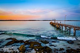
View of Vivonne Bay at sunset
|
|
| Location | Kangaroo Island, South Australia |
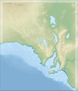
| Coordinates | 35°58′53″S 137°10′50″E / 35.98139°S 137.18056°E |
| Type | Bay |
| Primary inflows | Eleanor River Harriet River |
| Basin countries | Australia |
| Frozen | never |
| Settlements | Vivonne Bay |
Vivonne Bay (which means Vivonne Bay in French) is a beautiful bay in South Australia. It's located on the south coast of Kangaroo Island. The bay is about 61 kilometers (38 miles) from Kingscote, the main town on the island.
French explorers on the Baudin expedition to Australia named the bay in January 1803. A study of 10,000 beaches by Professor Andrew Short from Sydney University found that the beach at Vivonne Bay is one of the best in Australia!
Contents
Discovering Vivonne Bay
Where is Vivonne Bay Located?
Vivonne Bay is found on the south coast of Kangaroo Island in South Australia. It looks out over the Southern Ocean, which is also known as the Great Australian Bight by some international groups. It's about 61 kilometers (38 miles) southwest of Kingscote.
How Big is the Bay?
Vivonne Bay is like a curve in the coastline. It stretches between Point Ellen on the west side and the Eleanor River on the east. The Eleanor River is sometimes called the 'Mary River'. It's about 1.75 nautical miles (3.2 kilometers or 2 miles) north-northeast of Point Ellen.
How Deep is the Water?
The water in Vivonne Bay is usually between 9.1 and 11 meters (30 to 36 feet) deep. It's a good place for boats to anchor if they need shelter from winds coming from the north or west. However, it's not a good spot if strong winds come from the southeast. This is because there isn't enough room for boats to move safely if the wind gets too strong.
What is the Coastline Like?
The bay has a sandy beach that curves for about 5 kilometers (3 miles). The western part of the beach, near Point Ellen, is quite calm. The eastern part has stronger waves. These waves create sandbars offshore. The Eleanor River's mouth can get blocked by all the sand that moves around there.
Point Ellen is a grassy hill about 8.5 meters (28 feet) high. It has low rocks at its base and is made of a type of rock called "dune limestone". Two rivers flow into the bay: the Harriet River at the west end and the Eleanor River at the east end. The Harriet River forms a lagoon system at its mouth. This is different from most of Kangaroo Island's coastline, which has tall rock cliffs.
History of Vivonne Bay
Who Discovered and Named the Bay?
The bay was named by someone from the Baudin expedition to Australia in January 1803. It was named after either Louis Victor de Rochechouart de Mortemart (a French military leader) or Catherine de Vivonne, marquise de Rambouillet (a French noblewoman).
Some records say Nicolas Baudin named the bay. However, other sources suggest Baudin didn't visit the southern coast of Kangaroo Island himself. They say it was explored by a smaller ship called the Casuarina, led by Louis de Freycinet. Another source says both François Péron and Freycinet named the bay.
Safety at Vivonne Bay
Vivonne Bay is known for having strong currents (called an undertow) and sometimes big waves. Because of this, it's best suited for experienced swimmers.
In April 2011, two tourists were swept into the sea by a large wave at Point Ellen. This shows how important it is to be careful and aware of the ocean's power when visiting the bay. Always be safe near the water!
Bushfires Impact Vivonne Bay
In January 2020, bushfires affected Vivonne Bay. The fires were so serious that people living in the Vivonne Bay township and nearby areas had to leave their homes on January 9, 2020.
Life and Structures at Vivonne Bay
Settlements and Port Facilities
In the 1840s, there's some evidence that a whaling station operated in the bay. This was a place where people would process whales caught nearby.
A small community called Vivonne Bay is located along the coastline, close to where the Harriet River flows into the sea. The bay also has a jetty on the west side, next to Point Ellen. This jetty is about 79 meters (259 feet) long. As of 2014, there was a light on Point Ellen to help guide boats.
 | William M. Jackson |
 | Juan E. Gilbert |
 | Neil deGrasse Tyson |


