Pemulwuy, New South Wales facts for kids
Quick facts for kids PemulwuyGreater Western Sydney, New South Wales |
|||||||||||||||
|---|---|---|---|---|---|---|---|---|---|---|---|---|---|---|---|

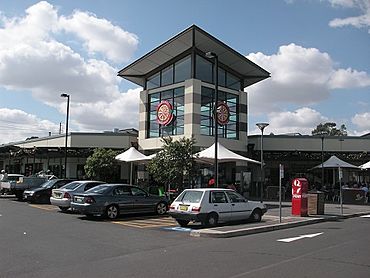
Pemulwuy Marketplace
|
|||||||||||||||
| Population | 5,009 (2016 census) | ||||||||||||||
| Postcode(s) | 2145 | ||||||||||||||
| Elevation | 69 m (226 ft) | ||||||||||||||
| Location | 30 km (19 mi) west of Sydney CBD | ||||||||||||||
| LGA(s) | Cumberland Council | ||||||||||||||
| State electorate(s) | Prospect | ||||||||||||||
| Federal Division(s) | McMahon | ||||||||||||||
|
|||||||||||||||
Pemulwuy is a suburb located in Greater Western Sydney, in New South Wales, Australia. It is about 30 kilometres west of the main Sydney central business district. Pemulwuy is special because it's home to Prospect Hill. This hill is the highest point between the Blue Mountains and Sydney.
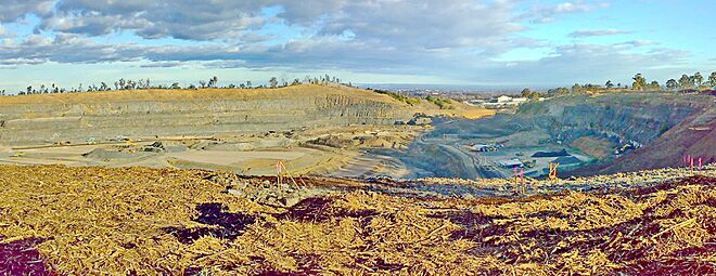
In the past, people dug up a lot of "blue metal" from the ground here. This material was used for building. Pemulwuy is a fairly new suburb. It started being built in 2004. Before that, it was a large quarry and a research site.
Contents
History of Pemulwuy
Who was Pemulwuy?
The suburb is named after an Aboriginal warrior called Pemulwuy. He was a brave leader who fought against the early British settlements. He especially led attacks on the settlement of Toongabbie.
In 1789, Captain-Lieutenant Watkin Tench explored the area. He wrote about Prospect Hill, which offered amazing views. He and his group were the first recorded colonists to climb Prospect Hill. This happened on June 26, 1789.
Early Settlers and Land Grants
In 1791, Governor Arthur Phillip started giving out land. These plots were given to convicts who had finished their sentences. Most of these land grants were between 30 and 70 acres. Thirteen land grants were made in July 1791.
By the 1820s, much of the land was cleared for farming. When Governor Macquarie visited in 1810, he was impressed by the farms.
Peace and Reconciliation
In 1801, Governor Philip Gidley King ordered that Aboriginal people should be "driven back" from settler homes. However, local Aboriginal groups suggested a meeting for peace. Reverend Samuel Marsden organized this meeting near Prospect Hill in May 1805. This meeting helped end the fighting between the Aboriginal clans and settlers.
The Prospect Quarry Story
People started digging for rocks in this area in the 1820s. Even the famous naturalist Charles Darwin visited in 1836 to study the rocks. Later, companies bought more land to expand their quarries. They dug up different types of rock, like dolerite.
For many years, Prospect Hill was the main source of rock for building roads in Sydney. The quarry created a large gap in the hill. By the end of World War II, most quarries closed. Only two remained, digging for the best quality rock.
Developing the Land Today
By 2001, the southern part of the land was heavily quarried. But the CSIRO site, used for research, still looked mostly natural. In 2002, two companies, Delfin Lend Lease and Boral, teamed up. They planned to build homes on the land.
On January 30, 2004, the eastern part of Prospect became the new suburb of Pemulwuy. New housing areas like Lakeside and Nelson's Ridge were built. The old quarry gap was also turned into an industrial area.
Quarrying stopped in 2007. From 2008 to 2010, the land inside the quarry gap was leveled. A new road, Reconciliation Road, was built through the middle of the hill. This road connects to Wetherill Park. In the early 2010s, the large quarry gap became an area for warehouses. Prospect Highway now goes through this area. New homes have been built, and more are still under construction.
Geography of Pemulwuy
The landscape of Prospect was once described as a "very pleasant tract of country." It looked like a huge park with gentle hills and grassy slopes. The soil was a mix of loam and clay. The main trees were grey box and forest red gum.
Prospect Hill, located in Pemulwuy, is made of igneous rock. This means it was formed from cooled lava. It rises to 117 metres above sea level. Millions of years ago, a volcanic event shaped Prospect Hill. It was once a larger volcanic core, but over time, it eroded down to the small bulge we see today.
The eastern part of Pemulwuy has many townhouses. The western area has large warehouses. The southern part is called "Nelson's Ridge" by developers. It's named after Nelson Simmons Lawson, whose family owned land here. The northern part is called "Lakewood."
Many street names in Pemulwuy have historical connections. For example, Watkin Tench Parade is named after Captain Watkin Tench.
Pemulwuy's Climate
| Climate data for Prospect Reservoir 1991–2020 averages, 1887–present extremes | |||||||||||||
|---|---|---|---|---|---|---|---|---|---|---|---|---|---|
| Month | Jan | Feb | Mar | Apr | May | Jun | Jul | Aug | Sep | Oct | Nov | Dec | Year |
| Record high °C (°F) | 47.0 (116.6) |
46.4 (115.5) |
39.5 (103.1) |
37.1 (98.8) |
29.4 (84.9) |
25.6 (78.1) |
26.5 (79.7) |
29.4 (84.9) |
35.0 (95.0) |
39.0 (102.2) |
42.0 (107.6) |
44.4 (111.9) |
47.0 (116.6) |
| Mean daily maximum °C (°F) | 29.3 (84.7) |
28.6 (83.5) |
26.8 (80.2) |
24.1 (75.4) |
20.7 (69.3) |
17.7 (63.9) |
17.2 (63.0) |
19.3 (66.7) |
22.4 (72.3) |
24.8 (76.6) |
26.1 (79.0) |
28.0 (82.4) |
23.8 (74.8) |
| Mean daily minimum °C (°F) | 18.0 (64.4) |
18.0 (64.4) |
16.2 (61.2) |
12.9 (55.2) |
9.7 (49.5) |
6.1 (43.0) |
6.6 (43.9) |
6.6 (43.9) |
9.5 (49.1) |
12.1 (53.8) |
14.5 (58.1) |
16.4 (61.5) |
12.3 (54.1) |
| Record low °C (°F) | 10.0 (50.0) |
10.8 (51.4) |
7.9 (46.2) |
3.6 (38.5) |
1.2 (34.2) |
−0.8 (30.6) |
−0.6 (30.9) |
−0.5 (31.1) |
1.7 (35.1) |
4.5 (40.1) |
6.8 (44.2) |
7.8 (46.0) |
−0.8 (30.6) |
| Average precipitation mm (inches) | 96.4 (3.80) |
126.9 (5.00) |
97.4 (3.83) |
67.4 (2.65) |
49.5 (1.95) |
76.1 (3.00) |
40.7 (1.60) |
39.7 (1.56) |
42.2 (1.66) |
55.3 (2.18) |
77.1 (3.04) |
75.5 (2.97) |
845.0 (33.27) |
| Average precipitation days (≥ 1mm) | 8.3 | 8.7 | 9.2 | 6.5 | 5.3 | 7.0 | 5.6 | 4.2 | 5.1 | 6.6 | 8.2 | 8.2 | 82.9 |
| Average afternoon relative humidity (%) | 52 | 54 | 55 | 50 | 57 | 54 | 52 | 43 | 45 | 44 | 51 | 51 | 51 |
| Source 1: Prospect Reservoir (1991–2020 averages) | |||||||||||||
| Source 2: Prospect Reservoir (1965–2018 extremes) Horsley Park (1997–present extremes) | |||||||||||||
Who Lives in Pemulwuy?
This section shares information about the people who live in Pemulwuy.
2016 Census Information
- The most common backgrounds were Indian (13.3%), Australian (12.0%), and English (9.1%).
- About 46.1% of people spoke only English at home. Other languages included Hindi (5.8%) and Arabic (4.3%).
- Over half (51.5%) of the people were born in Australia. Many others came from India (9.4%) and the Philippines (4.7%).
- For religion, Catholic was the most common (33.3%), followed by Hinduism (15.2%).
2011 Census Information
- The most common backgrounds were Australian (15.0%), English (10.8%), and Indian (10.3%).
- About 48.9% of people spoke only English at home. Other languages included Hindi (6.0%) and Arabic (4.2%).
- Over half (52.4%) of the people were born in Australia. Many others came from India (7.2%) and the Philippines (6.7%).
- For religion, Catholic was the most common (40.2%), followed by Hinduism (11.8%).
Shopping and Services
The Pemulwuy Marketplace is a local shopping centre. It's located where Greystanes Road and Butu Wargun Drive meet. This marketplace has a Woolworths supermarket and a BWS store. There's also a community centre and a child care centre nearby. Another shopping area, Nelsons Ridge Plaza, is on Watkin Tench Parade.
Parks and Green Spaces
Pemulwuy has many great parks and reserves for everyone to enjoy:
- Grey Box Reserve
- Dirrabari Reserve (which has a special dog park)
- Driftway Reserve
- Andrew Campbell Reserve
- Marrong Reserve or Pemulwuy Lookout (This is the highest point in the suburb. It has a lookout, native plants, and places to sit. You can only get there by walking or cycling.)
- Ridgeline Reserve
- Wittama Park
- Nelson Square
Getting Around Pemulwuy
Buses serve the Pemulwuy area. You can catch the Transit Systems Sydney 809 bus from Merrylands. There are also 810x and 811x buses from Parramatta. Buses 800 and 812 connect Pemulwuy to Blacktown and Fairfield.
If you live in the eastern part of Pemulwuy and work in the western part, you might need to walk or cycle over the hill. Or you can drive using the Great Western Highway and Reconciliation Road.
Pemulwuy is very close to major roads. It's a 5-minute drive to the M4 motorway. It's also only a 10-minute drive to Parramatta. Train stations like Merrylands railway station and Pendle Hill railway station are just a few minutes away by car.
 | William M. Jackson |
 | Juan E. Gilbert |
 | Neil deGrasse Tyson |


