
Smithfield, New South Wales facts for kids
Quick facts for kids SmithfieldSydney, New South Wales |
|||||||||||||||
|---|---|---|---|---|---|---|---|---|---|---|---|---|---|---|---|

Smithfield Town Centre
|
|||||||||||||||
| Population | 13,160 (2021 census) | ||||||||||||||
| Established | 1836 | ||||||||||||||
| Postcode(s) | 2164 | ||||||||||||||
| Elevation | 23 m (75 ft) | ||||||||||||||
| Location | 31 km (19 mi) west of Sydney | ||||||||||||||
| LGA(s) |
|
||||||||||||||
| State electorate(s) |
|
||||||||||||||
| Federal Division(s) | McMahon | ||||||||||||||
|
|||||||||||||||
|
|||||||||||||||
Smithfield is a suburb located in Sydney, New South Wales, Australia. It is about 31 kilometers (19 miles) west of the main city center of Sydney. Smithfield is part of two local government areas: the City of Fairfield and Cumberland Council. It is one of the largest suburbs in the Fairfield City area.
Smithfield was first settled in 1836. It was the first big settlement in the Fairfield area. The original plan for Smithfield from 1838 shows streets laid out in a grid. Many of these streets still have the same names today. The land in Smithfield is between 21 and 48 meters (69 to 157 feet) above sea level. It sits on a flat area called the Cumberland Plain. Smithfield has homes, factories, and shops, but mostly has houses with lots of space around them.
Part of Smithfield is home to the Smithfield-Wetherill Park Industrial Estate. This is the largest industrial area in the southern half of the world. It is a major center for making and distributing goods in western Sydney. Smithfield West is a smaller part of the suburb. It is the unofficial name for the area west of Dublin Street, reaching the border of Wetherill Park.
Contents
History of Smithfield
Who Lived Here First?
For over 30,000 years, Aboriginal people lived in the Fairfield area. They were from the Cabrogal tribe, which is a part of the Gandangara tribe.
Early European Settlement
European settlers started arriving in the early 1800s. Smithfield was first known as Chilsholm's Bush. By 1867, Smithfield was a small rural settlement. People grew grapes and other plants, cut wood, and ran tanneries (places that make leather). Early settlers liked Smithfield because it had good soil and a reliable water supply. It was also easy to get to the main towns of the colony. Some of the best farming land was to the west and southwest of Smithfield.
How Smithfield Got Its Name
In 1803, many children were homeless. Governor Philip Gidley King set aside a large area of land for a school for boys without homes. By 1836, some of this land was sold by the government. John Ryan Brenan, a lawyer and police officer, bought 1,650 acres here.
Brenan wanted to make money by creating a meat market and a place to sell cattle. He divided the land and named it Smithfield. He chose this name after the famous meat markets in London and Dublin. The cattle yards opened in 1841, but his plan for a village around them did not work out. Even so, Smithfield became a busy business center. It is still an important place for jobs in southwestern Sydney.
Smithfield still has the street layout and names that Brenan planned. He even offered extra land to buyers who built a small house with a brick chimney and a fence. A public school opened in 1850. By the 1880s, Smithfield had many churches. Many of these old churches are still standing today. They are important parts of Smithfield's history.
Getting Around Smithfield
Main Roads and Buses
The Horsley Drive is the most important road that goes through Smithfield. Other big roads include Polding Street, Brennan Street, and Victoria Street. Victoria Street has many factories.
Transit Systems Sydney provides bus services in the area. The closest train station is Fairfield train station. This station is on the Inner West & Leppington Line and Cumberland Line. Buses 806, 808, 812, 813, 814, and 817 go through Smithfield and connect to Fairfield station. Bus 806 also goes to Parramatta railway station and Liverpool railway station.
Bike Paths
There is a bike path called Prospect Creek Cyclepath that runs through Smithfield. It is part of the Western Sydney Regional Park and is a great route for recreation.
Shopping and Business Areas
Town Centre
The main shopping area is along The Horsley Drive. This is the most important road running east-west in the region. It connects Carramar and Wetherill Park. The road is decorated with several large curtain fig trees. The main street has health services, a gym, beauty shops, and other businesses. You can also find many different restaurants, including Italian, Middle Eastern, and Chinese food. A Coles supermarket used to be here but closed in late 2022 for a big renovation.
Industrial Area
Smithfield has a very large industrial area with many factories and warehouses. This industrial estate is the biggest in the southern hemisphere. It is a key place for making and distributing goods in the wider western Sydney area.
Culture and Community
Smithfield has an art gallery, a museum, and an RSL club. The TV show Housos was filmed in Smithfield and other locations. Smithfield Cemetery was started in the 1800s. It is in the western part of the suburb and is now looked after by the Syriac Orthodox Church.
Places of Worship
Smithfield has many different churches and temples:
- Smithfield Baptist Church is on the corner of The Horsley Drive and O’Connel Street.
- St James Anglican Church is on the corner of The Horsley Drive and Justin Street.
- St Benedicts Catholic Church is located in Justin Street.
- Smithfield Uniting Church is on The Horsley Drive.
- Minh Giac Temple, a Vietnamese Buddhist temple, is on The Horsley Drive.
- St Mary's Church, an Assyrian church, is located in Polding Street.
- Smithfield Mosque, also known as the Australian Bosnian Islamic Society Gazi Husrevbeg, is in Bourke Street.
Parks and Green Spaces
Brenan Park
Brenan Park is a large park and one of the most important in Fairfield City. It has sports grounds, playgrounds for children, and areas for picnics.
Rosford Street Reserve
Rosford Street Reserve is a park in the northern part of Smithfield. It has a large sports ground and a natural forest area. It is next to Long Street Park, which is in the Cumberland Council part of Smithfield.
Special Plant Area
Next to the cemetery, there is a small area with special plants. This area is part of the Cooks River/Castlereagh Ironbark Forest, which is an endangered plant community. It has Eucalyptus fibrosa and Eucalyptus moluccana as the main tall trees.
Weather in Smithfield
Smithfield has a humid subtropical climate. This means it has warm to hot summers and cool, sometimes mild, winters. It rains throughout the year. Smithfield is usually a few degrees warmer than Sydney city on summer days. It is also a few degrees cooler on winter nights. Sometimes, there can be a 5-degree Celsius difference in summer because of sea breezes in the city that don't reach inland. In extreme cases, the difference can be 10 degrees. Smithfield gets about 300mm less rain each year than the main Sydney city area. The least rain falls in late winter and early spring. More rain falls in late summer and autumn.
| Climate data for Prospect Reservoir | |||||||||||||
|---|---|---|---|---|---|---|---|---|---|---|---|---|---|
| Month | Jan | Feb | Mar | Apr | May | Jun | Jul | Aug | Sep | Oct | Nov | Dec | Year |
| Record high °C (°F) | 47.0 (116.6) |
46.4 (115.5) |
39.5 (103.1) |
37.1 (98.8) |
29.4 (84.9) |
25.6 (78.1) |
26.5 (79.7) |
29.4 (84.9) |
35.0 (95.0) |
39.0 (102.2) |
42.0 (107.6) |
44.4 (111.9) |
47.0 (116.6) |
| Mean daily maximum °C (°F) | 29.3 (84.7) |
28.6 (83.5) |
26.8 (80.2) |
24.1 (75.4) |
20.7 (69.3) |
17.7 (63.9) |
17.2 (63.0) |
19.3 (66.7) |
22.4 (72.3) |
24.8 (76.6) |
26.1 (79.0) |
28.0 (82.4) |
23.8 (74.8) |
| Daily mean °C (°F) | 23.6 (74.5) |
23.3 (73.9) |
21.5 (70.7) |
18.5 (65.3) |
15.2 (59.4) |
11.9 (53.4) |
11.9 (53.4) |
12.9 (55.2) |
15.9 (60.6) |
15.9 (60.6) |
20.3 (68.5) |
22.2 (72.0) |
17.8 (64.0) |
| Mean daily minimum °C (°F) | 18.0 (64.4) |
18.0 (64.4) |
16.2 (61.2) |
12.9 (55.2) |
9.7 (49.5) |
6.1 (43.0) |
6.6 (43.9) |
6.6 (43.9) |
9.5 (49.1) |
12.1 (53.8) |
14.5 (58.1) |
16.4 (61.5) |
12.3 (54.1) |
| Record low °C (°F) | 10.0 (50.0) |
10.8 (51.4) |
7.9 (46.2) |
3.6 (38.5) |
1.2 (34.2) |
−0.8 (30.6) |
−0.6 (30.9) |
−0.5 (31.1) |
1.7 (35.1) |
4.5 (40.1) |
6.8 (44.2) |
7.8 (46.0) |
−0.8 (30.6) |
| Average precipitation mm (inches) | 83.3 (3.28) |
145.9 (5.74) |
132.3 (5.21) |
72.9 (2.87) |
43.0 (1.69) |
79.3 (3.12) |
36.9 (1.45) |
37.7 (1.48) |
39.4 (1.55) |
62.5 (2.46) |
75.6 (2.98) |
73.7 (2.90) |
863.5 (34.00) |
| Average precipitation days (≥ 1mm) | 8.3 | 8.7 | 9.2 | 6.5 | 5.3 | 7.0 | 5.6 | 4.2 | 5.1 | 6.6 | 8.2 | 8.2 | 82.9 |
| Average afternoon relative humidity (%) | 52 | 54 | 55 | 50 | 57 | 54 | 52 | 43 | 45 | 44 | 51 | 51 | 51 |
| Source 1: Prospect Reservoir (1991–2018 averages) | |||||||||||||
| Source 2: Prospect Reservoir (1965–2018 extremes) Horsley Park (1997–present extremes) Greystanes (monthly rainfall) | |||||||||||||
Schools in Smithfield
Smithfield has two local primary schools: Smithfield Public School and Smithfield West Public School. There are no high schools directly in Smithfield. However, students living in the western part of Smithfield can attend Westfields Sports High School. Those in the southeastern part can go to Fairfield High School. There is also a TAFE college nearby in Wetherill Park for vocational training. Other high schools in nearby suburbs include Holroyd High School, Patrician Brothers College, Warakirri College, Merrylands High School, Cerdon College, Canley Vale High School, and Fairvale High School.
Who Lives in Smithfield?
According to the 2021 Australian Bureau of Statistics Census, 13,160 people usually live in Smithfield. The average age of people in Smithfield was 38 years old. The unemployment rate was 8.9%.
Different Backgrounds
The most common backgrounds of people in Smithfield are Australian (12.7%), Assyrian (11.4%), English (10.0%), Vietnamese (9.2%), and Iraqi (9.0%).
Only 31.2% of people speak only English at home. Other languages spoken include Arabic (15.3%), Assyrian Neo-Aramaic (10.5%), Vietnamese (9.6%), Chaldean Neo-Aramaic (5.7%), and Spanish (3.2%). If you combine Assyrian and Chaldean Aramaic, then Neo-Aramaic is the most common language after English, at 16.2%.
Where People Were Born
About 42.4% of people in Smithfield were born in Australia. For 13.7% of people, both parents were born in Australia. For 72.9% of people, both parents were born overseas. Other common countries of birth include Iraq (18.1%), Vietnam (6.9%), Syria (4.8%), Italy (2.3%), and Lebanon (2.2%).
Religious Beliefs
Almost three out of four residents (68.4%) are Christian. The most common religions are Catholic (38.4%), No Religion (10.6%), Islam (9.4%), Buddhism (8.0%), and Assyrian Apostolic (6.8%).
Types of Homes
Most homes in Smithfield are separate houses, making up 77.3% of all private homes. About 10.7% are semi-detached houses or townhouses. Flats or apartments make up 10.2%, and other types of homes are 1.5%.
About 27.3% of homes are fully owned. Another 26.4% are owned with a mortgage (a loan). About 43.0% of homes are rented.
- 7.1% of homes have 1 bedroom.
- 15.2% have 2 bedrooms.
- 43.7% have 3 bedrooms.
- 32.0% have 4 or more bedrooms.
The average home has 3.1 bedrooms.
About 51.2% of families are couples with children. 24.1% are couples without children. 22.4% are one-parent families. Of the single parents, 15.9% are male and 84.8% are female.
Famous People from Smithfield
- Harry Kewell, a famous footballer who played for the socceroos (Australia's national soccer team).
- Chris Bowen, a politician who works in the government.
Images for kids
-
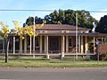
Smithfield Museum
-
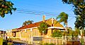
St Mary's Church, an Assyrian place of worship
-
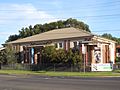
Smithfield Gallery
-
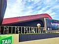
Smithfield Tavern


