
Buxton, New South Wales facts for kids
Quick facts for kids BuxtonNew South Wales |
|||||||||||||||
|---|---|---|---|---|---|---|---|---|---|---|---|---|---|---|---|

East Parade, Buxton, looking south
|
|||||||||||||||
| Population | 2,071 (2021 census) | ||||||||||||||
| Postcode(s) | 2571 | ||||||||||||||
| Elevation | 396 m (1,299 ft) | ||||||||||||||
| Location |
|
||||||||||||||
| LGA(s) | Wollondilly Shire | ||||||||||||||
| Region | Macarthur | ||||||||||||||
| State electorate(s) | Wollondilly | ||||||||||||||
| Federal Division(s) | Hume | ||||||||||||||
|
|||||||||||||||
Buxton is a small village located in the Macarthur Region of New South Wales, Australia. It's part of the Wollondilly Shire. In 2021, about 2,071 people lived here. The village got its name from a town called Buxton, Derbyshire in England.
Contents
Exploring Buxton's Location
Buxton is surrounded by natural beauty and other towns. To the north, you'll find Couridjah. To the west is the peaceful Thirlmere Lakes National Park.
South of Buxton is Balmoral. To the east, you can explore the Bargo State Recreation Area. The main roads and railway line in Buxton run from north to south.
Who Lives in Buxton?
In 2021, the village of Buxton had 2,071 residents. Most people, about 86.1%, were born in Australia. Also, 93.0% of homes spoke only English. Many people in Buxton follow different religions. About 40.1% said they had no religion. Others were Catholic (21.9%) or Anglican (21.1%).
Learning in Buxton
Buxton has its own school for younger students.
Buxton Public School
Buxton Public School is on Hassall Road, at the northern end of the village. Around 200 students attend this school. After primary school, older students travel by bus to high schools. These include Picton High School and Wollondilly Anglican College. Some also go to schools in the Southern Highlands, like Bowral High School or Chevalier College.
Buxton School of Arts Hall
The Buxton School of Arts Hall is on West Parade. This hall is a community hub. It hosts playgroups for young children and an art group. There's also a community garden behind the hall. Local groups, businesses, and families can rent the hall for events.
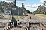
Buxton's Railway History
The village of Buxton grew around its railway station. This station was first built in 1883. A platform was added in 1893. The current platform was built later by the Rotary Club of Picton Inc. This helped with tourist train services in the 1990s.
The Original Railway Line
The first railway line had very steep sections. Because of this, the railway was changed on July 13, 1919. A new line was built to the east, going through Bargo. This new line became the main railway. The original line became known as the Picton Loop line.
The Picton Loop Line Today
The Loop Line stopped being used in 1978. This was because there wasn't much train traffic. Also, a road bridge between Colo Vale and Braemar failed. However, the part of the line from Picton to Buxton was saved. It is now a heritage railway. The NSW Rail Museum still operates trains on this historic section.
Buxton Photo Gallery
-
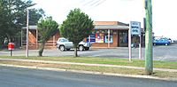
Shopping Centre, East Parade -
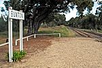
Station on Loop Line (closed) -
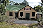
School of Arts Hall -
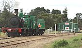
Locomotive at Buxton Station -
Rural Fire Brigade Shed


