
Batlow, New South Wales facts for kids
Quick facts for kids BatlowNew South Wales |
|||||||||
|---|---|---|---|---|---|---|---|---|---|

Entering Batlow
|
|||||||||

Batlow
Location in New South Wales
|
|||||||||
| Population | 1,270 (2021 census) | ||||||||
| Established | 1850s | ||||||||
| Postcode(s) | 2730 | ||||||||
| Elevation | 775 m (2,543 ft) | ||||||||
| Location |
|
||||||||
| LGA(s) | Snowy Valleys Council | ||||||||
| County | Wynyard | ||||||||
| State electorate(s) | Wagga Wagga | ||||||||
| Federal Division(s) | Eden-Monaro | ||||||||
|
|||||||||
Batlow is a town in the South West Slopes region of New South Wales, Australia. It sits on the edge of the Great Dividing Range, about 775 meters above sea level.
Batlow is famous for its apples! Around 50 local farmers grow apples here. They produce about 1.6 million cases of apples each year, which is 10% of all the apples grown in Australia. The area also grows cherries and other stone fruits like peaches. A giant "Big Apple" landmark, located 5 km north of town, shows how important fruit farming has been to Batlow for over 120 years.
Contents
Batlow's Story
Before Europeans arrived, the Wiradjuri people lived in the Batlow area. The first Europeans to explore this land were Hamilton Hume and William Hovell in 1824.
Gold Rush to Fruit Bowl
In 1854, gold was found nearby. A small settlement called Reedy Creek started as a place to get supplies for the miners. A person named Mr. Batlow surveyed a town site close by. The gold didn't last long, but farmers discovered the land was great for growing different crops. So, the supply point moved, and the town of Batlow was officially set up around 1855.
The Reedy Flat Post Office opened in 1873 and was renamed Batlow in 1889. Growing fruit and cutting timber quickly became the main ways people made money. In 1910, the town area was officially recognized.
Growing and Changing
In 1922, Batlow built the first cool stores in New South Wales. These special buildings kept fruit fresh. At the same time, a railway line was built from nearby Tumut. These changes made it easier for Batlow to send its fruit to Sydney and other places.
During World War II, Batlow helped by supplying dried fruit and vegetables to soldiers. Many Land Army Girls worked in Batlow during the war. You can find many items from their time at the Historical Society Museum. There are also two special farming areas near Batlow, called Willigobung and Kunama, which were set up for soldiers after the war.
Recent Times
On January 4, 2020, a large bushfire caused some damage to the town. At least 17 homes were destroyed, and hundreds of apple trees were scorched.
People of Batlow
In the 2016 Census, there were about 1,313 people living in Batlow. Most people (76.3%) were born in Australia, and most (81.5%) spoke only English at home. When asked about religion, the most common answers were No Religion (27.0%), Anglican (24.5%), and Catholic (20.4%).
Weather and Location


Batlow is about 94 kilometers west of Canberra in a straight line. However, because of the Great Dividing Range, driving there is about 225 kilometers. The closest big city is Wagga Wagga. Three other towns are within 40 kilometers: Tumut to the northeast, Adelong to the northwest, and Tumbarumba to the southwest.
The land around Batlow is a plateau (a high, flat area) with rolling hills, often reaching 1,000 meters high. Because it's on the western side of the Great Dividing Range, Batlow gets a lot of rain. It receives about 1,222.3 millimeters of rain each year, mostly in winter. The cold, often snowy winters, along with good rainfall and soil, make it a perfect place to grow apples.
Bago Plateau Climate
The Bago Plateau, south of Batlow, is even colder and wetter because it's higher up. Snow often falls from June to September. Sometimes, heavy snow can stay on the ground for more than a week. It can even snow in late spring or early summer, though this is rare. The area often has heavy cloud cover in winter.
Batlow Today

Batlow is an agricultural town that provides services to the surrounding area. It has two primary schools and a high school, a library, a town hall, and several shops and small businesses. The Batlow Fruit Co-operative, which has been trading since 1922, is still based in the town.
Batlow used to have a cannery called 'Mountain Maid'. This factory, built during World War II, made food for the allied troops. It closed in the early 2000s. The steel frame of the building was a landmark for many years until it was mostly destroyed in the January 2020 bushfire.
Batlow's economy mainly relies on growing apples for people to eat fresh. The town also makes money from other farming activities and from timber from its large pine and hardwood forests. Many seasonal workers come to Batlow to help harvest fruit from March to April. A smaller group comes in December to help thin the fruit. There are also people who produce cherries, nuts, honey, and eucalyptus oil products.
Nature and Forests
The 43,000-hectare Bago State Forest is located between Batlow and Tumbarumba. It has tall alpine ash trees and radiata pine trees. Fun places to visit include the Pilot Hill Arboretum, which started in the 1920s, and the Sugar Pine Walk. The Sugar Pine Walk is a beautiful path lined with giant sugar pine trees that look like a natural cathedral.
Festivals and Events
Every year, on the third Saturday of May, the Batlow Ciderfest is held in the main street. This festival shows off ciders made locally and from the region, along with local food. Many interesting stalls are also part of this family-friendly event. The Ciderfest came in second place at the NSW Event awards just three years after it began. On the Friday before the festival, a Cider Industry Conference is held. A 'Living Food conference' was also added to the CiderFest weekend.
On the third Saturday of October, the Apple Blossom Festival takes place. This revived festival first started in 1942, and the very first Apple Blossom Queen was a Land Army girl.
Fruit Bowl Sculpture
This amazing sculpture was carved by Fred Alwahan in 1994. He used the trunk of a red oak tree on Mayday Road in Batlow, NSW. It stands over two meters tall. A plaque explains that Alwahan gave this artwork to the town to honor its early settlers.
-
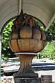
The Fruit Bowl sculpture
-
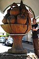
Close-up of the fruit bowl details


