
Menindee Lakes facts for kids
Quick facts for kids Menindee Lakes |
|
|---|---|

Aerial view of the Darling River and some of the Menindee Lakes
|
|

Menindee Lakes
Location in New South Wales
|
|
| Location | Far West, New South Wales |
| Coordinates | 32°20′59″S 142°22′08″E / 32.34972°S 142.36889°E |
| Lake type | Ephemeral fresh water |
| Primary inflows | Darling River |
| Primary outflows | Darling River |
| Catchment area | 273,229 square kilometres (105,494 sq mi) |
| Basin countries | Australia |
| Managing agency | Murray Darling Basin Authority |
| Designation | National park: Kinchega |
| Built | 1949 |
| First flooded | 1968 |
| Max. length | 16 kilometres (9.9 mi) (Lake Menindee only) |
| Max. width | 14 kilometres (8.7 mi) (Lake Menindee only) |
| Surface area | 47,500 hectares (117,000 acres) |
| Average depth | 7 metres (23 ft) |
| Water volume | 1,731,000 megalitres (1.403×10⁶ acre⋅ft) |
| Surface elevation | 60 metres (200 ft) AHD |
| Settlements | Menindee |
The Menindee Lakes are a group of shallow, freshwater lakes. They are connected to the Darling River and work together as a water storage system. You can find them in the far west of New South Wales, Australia, close to the town of Menindee.
The Menindee Lakes Water Storage Scheme helps supply water to many places. This includes the city of Broken Hill, areas along the lower Darling River, and farms and towns along the Murray River in New South Wales, Victoria, and South Australia. This is all part of the Murray-Darling Basin Agreement. Seven of these lakes are part of a special system. This system helps control floods and stores water for homes, farms, and animals downstream. The lakes are also very important for waterbirds.
Contents
Where are the Menindee Lakes?

The lakes are about 110 kilometres (68 mi) south-east of Broken Hill. They are in a semi-dry area. The ground around them is made of clay, sand, and other rocky materials.
The lakes vary in size, from 103 hectares (250 acres) to 15,900 hectares (39,000 acres). The biggest ones are Lake Menindee, Lake Wetherell, Lake Pamamaroo, and Lake Cawndilla. These four, along with Lake Tandure, Lake Bijijie, and Lake Balaka, are part of the Menindee Lakes Water Storage Scheme. Lake Cawndilla and Lake Menindee are also inside the Kinchega National Park. Other lakes, like Nettlegoe, Kangaroo, Stir Tank, New, and Malta, are not controlled by the scheme. Lake Tandou is now used for farming and does not flood anymore.
The edges of the lakes that sometimes overflow have many dead black box trees. The shores are covered with plants like bluerod and sandhill canegrass.
How the Lakes Store Water
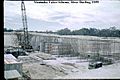
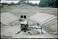
The Menindee Lakes Storages is a large system of dams and weirs. It includes a concrete spillway with six gates. The lakes were naturally low areas that filled up during floods. When the floodwaters went down, the water would flow back into the Darling River.
In 1949, people started building dams, weirs, walls, and canals. These were made to catch and hold floodwaters. Most of the work was finished by 1960, and the whole project was done in 1968. There were also electrical updates in 2007. The New South Wales Water Conservation and Irrigation Commission built this system. It helps manage river flows, provides water for towns, farms, and industries, and helps prevent floods. It has become very important for managing water for the environment too.
To build the retaining walls, workers used 103 cubic metres (3,600 cu ft) of rock. The walls are 18 metres (59 ft) high and 95 metres (312 ft) long. The water in the lakes is usually about 7 metres (23 ft) deep. When the lakes are completely full, they can hold 1,731,216 megalitres (61,137.3×106 cu ft) of water. This water is about 60 metres (200 ft) above sea level. The total surface area of the lakes in the scheme is 47,500 hectares (117,000 acres). The area that collects water for the lakes is 273,226 square kilometres (105,493 sq mi). The spillway can release water at a rate of 850 cubic metres per second (30,000 cu ft/s).
Amazing Birds of the Lakes
A large area of the lakes and their surroundings, about 423 square kilometres (163 sq mi), has been named an Important Bird Area (IBA) by BirdLife International. This is because it is home to many waterbirds, sometimes as many as 222,000!
The lakes are especially important for certain types of birds. Over 1% of the world's population of freckled ducks, grey teals, pink-eared ducks, red-necked avocets, sharp-tailed sandpipers, and red-capped plovers can be found here. Other waterbirds that often use the lakes in large numbers include Australasian shovellers, Australian shelducks, pied cormorants, yellow-billed spoonbills, Eurasian coots, and white-headed stilts. Other bird species seen in this important area are the Australian bustard, black and pied honeyeaters, chirruping wedgebill, and grey falcon.
Images for kids
-
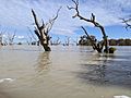
After the floods of 2022
-
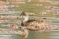
The lakes are important for grey teals
-
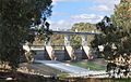
Main Weir on the Darling River at the Menindee Lakes, 2009.
-
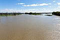
Menindee Lakes viewed from the Main Weir, 2012.
-
Dam construction, 1959.
-
Construction at Menindee Lakes Scheme, 1959.


