Loddon River facts for kids
Quick facts for kids Loddon |
|
|---|---|

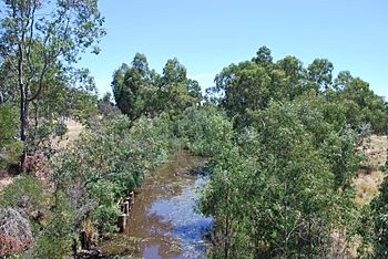
Loddon River at Newstead
|
|
| Native name | Yolelerwil-meerin, Yarrayn, Woppoon, Byerr, Pullergil-yaluk, Gunbungwerro, Minne-minne, Mudyin gadjin |
| Country | Australia |
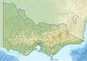
| State | Victoria |
| Region | Riverina bioregion (IBRA), Central Highlands, Loddon Mallee |
| LGAs | Hepburn, Mount Alexander, Loddon, Gannawarra |
| Towns | Newstead, Bridgewater, Serpentine, Kerang |
| Physical characteristics | |
| Main source | Great Dividing Range Musk 638 m (2,093 ft) 37°24′19.5″S 144°14′31.5″E / 37.405417°S 144.242083°E |
| River mouth | Little Murray River Kerang 71 m (233 ft) 35°33′4.7″S 143°53′0.5″E / 35.551306°S 143.883472°E |
| Length | 392 km (244 mi) |
| Basin features | |
| River system | Murray-Darling basin |
| Basin size | 15,320 km2 (5,920 sq mi) |
| Tributaries |
|
| Nature reserve | Upper Loddon Flore Reserve |
The Loddon River is an important inland river in Victoria, Australia. It is part of the huge Murray-Darling river system. The river starts in the Great Dividing Range mountains, east of Daylesford. It then flows north until it joins the Little Murray River near Swan Hill.
Along its path, the Loddon River has two main dams: the Cairn Curran Reservoir and the Laanecoorie Reservoir. These dams help store water. Another important stream, Tullaroop Creek, also has a dam called Tullaroop Reservoir before it joins the Loddon River.
Contents
About the Loddon River
The Loddon River is the second longest river in Victoria. Only the Goulburn River is longer. The Loddon River helps drain a large part of central Victoria. From where it starts to where it ends, the river drops about 567 metres (1,860 ft) in height. It flows for about 392 kilometres (244 mi).
The river begins near Musk and Trentham. It flows north through towns like Glenlyon, Guildford, and Newstead. After Newstead, the river flows into the Cairn Curran Reservoir. It then continues north through Baringhup and Eddington.
Further north, the river reaches the Laanecoorie Reservoir. It then flows to Newbridge and Bridgewater On Loddon. At Bridgewater, many people enjoy waterskiing, swimming, and fishing.
River Flow and Features
After Bridgewater, the river passes Serpentine. Here, water is sent to the Waranga Western Channel through a weir. Downstream from this weir, the river is usually 7 to 14 metres (23 to 46 ft) wide. In some places, it can be up to 26 metres (85 ft) wide.
About 10 kilometres (6.2 mi) south of Kerang, more water flows into the river from the Macorna Channel. This extra water helps the river flow strongly for the next 15 kilometres (9.3 mi) up to the Kerang Weir. The last part of the river flows through areas with saltbush and Black Box trees. The Loddon River finally joins the Little Murray River near Swan Hill.
Fun Activities on the River
The Loddon River is a great place for outdoor activities, especially when water levels are good.
Watersports and Boating
- Kayaking: Downstream from the Calder Highway bridge, there's a spot called Mill Rapid. It's good for experienced whitewater kayaking. Upstream, kayakers and canoeists can enjoy a calm paddle.
- Waterskiing: At Bridgewater, there are special areas for waterskiing. One is 3.2 kilometres (2.0 mi) long for general skiing. Another is 950 metres (3,120 ft) long for slalom and ski jumping. Big events like the Australian Masters are held here.
- Swimming: There's a 90 metres (300 ft) swimming area at the Flour Mill Weir in Bridgewater.
- Boating: Both the Cairn Curran and Laanecoorie reservoirs are popular for motorboats and sailing. You can launch boats from the bank at the Loddon Weir.
Fishing Opportunities
The Loddon River is home to many fish.
- Between Bridgewater and Serpentine, you can find Murray cod and golden perch.
- Downstream from the Loddon Weir, the water can be 5 to 7 metres (16 to 23 ft) deep. This area is good for catching redfin, golden perch, silver perch, and carp. You might also find Murray cod.
- In 2008, a fish ladder was built next to the Kerang Weir. This helps fish move past the weir.
- In the lower parts of the river, the main fish species are redfin, golden perch, and Murray cod.
Water Management
There are weirs in Bridgewater and Kerang. These weirs help keep water in the towns. Without them, parts of the river might dry up in summer. Experts are working to make sure enough water flows through the river to keep it healthy for nature.
River Crossings
Many roads and bridges cross the Loddon River.
- Near the start, the Daylesford-Malmsbury Road crosses at Glenlyon. The Drummond-Vaughan Forest Road crosses in three places.
- Further north, the Midland Highway crosses south of Guildford. The Pyrenees Highway crosses in Newstead.
- At Laanecoorie, the river is crossed by the Janevale bridge. This is a historic concrete bridge built in 1911.
- The Wimmera Highway crosses at Newbridge.
- At Bridgewater, the Calder Highway and the Eaglehawk-Inglewood railway line cross the river.
- In Kerang, the Murray Valley Highway and the Yungera railway line cross.
- Further crossings include the Wells Bridge, which carries the Lake Charm Road.
River Names and History
The Loddon River has been important to Indigenous peoples for a very long time. Different groups had their own names for the river.
- In some Indigenous languages, the river was called Yolelerwil-meerin and Byerr.
- The Djadjawurrung language names include Yarrayn, Minne-minne, and Pullergil-yaluk.
- In the Wembawemba language, it was called Woppoon.
- The Djadjawurrung and Barababaraba peoples called it Gunbungwerro. The word werro or wurru means "lips" or "mouth."
- The Gannawarra and Barababaraba peoples also called it Mudyin gadjin, which means "he picked up water."
The name "Loddon River" was given by an explorer named Thomas Mitchell in 1836. He named it after another river called the River Loddon in England.
See also
 In Spanish: Río Loddon para niños
 | Ernest Everett Just |
 | Mary Jackson |
 | Emmett Chappelle |
 | Marie Maynard Daly |


