River Loddon facts for kids
Quick facts for kids Loddon |
|
|---|---|
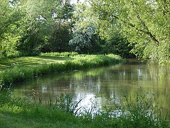
River Loddon near Stratfield Saye
|
|
|
Inflow to the Thames, south of Wargrave
|
|
| Country | England |
| Counties | Hampshire (both current types), Berkshire (ceremonial only) |
| Districts / Boroughs | Basingstoke and Deane (Borough), Hart District (brief border), Wokingham Borough, West Berkshire (brief border) |
| Town, suburban towns and small town | Basingstoke, Earley, Woodley, Twyford |
| Physical characteristics | |
| Main source | Basingstoke, Hampshire, United Kingdom 100 m (330 ft) 51°15′53″N 1°06′57″W / 51.264614°N 1.115713°W |
| River mouth | River Thames Wargrave, Berkshire, United Kingdom 33 m (108 ft) 51°30′06″N 0°52′48″W / 51.50169°N 0.880001°W |
| Length | 45 km (28 mi) |
| Basin features | |
| Progression | Loddon, Thames |
| River system | Thames Basin |
| Basin size | 1,036 km2 (400 sq mi) |
| Tributaries |
|
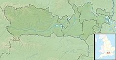
The River Loddon is a river in southern England. It flows into the River Thames. The Loddon starts in Basingstoke, Hampshire. It then flows north for about 28 miles (45 km). Finally, it joins the Thames near Wargrave in Berkshire. The Loddon and its smaller rivers drain an area of about 400 square miles (1,000 km2).
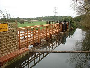
For a long time, the river powered many mills. These mills used the river's flow to create power. People built weirs and sluices to control the water for the mills. Most mills used water wheels, but some used water turbines. These mills were used for different things. Some ground corn, one was a silk mill, and another was a paper mill. Today, many old mills are homes or hotels. Longbridge Mill has been fixed up and still works sometimes. People also use the river for fun activities like canoeing when the water is not too high.
The River Loddon is home to many different animals and plants. Old gravel pits along the river have become nature reserves. These include Loddon Nature Reserve and Dinton Pastures Country Park. A part of the river is a special protected area. It is called a Site of Special Scientific Interest (SSSI). This is because rare plants like certain bulbs and pondweed grow there. The river has also been improved to help fish. For example, a special fish bypass was built at Arborfield Mill. This helps fish like salmon swim upstream.
Contents
Where the River Loddon Flows
The River Loddon starts in Basingstoke, Hampshire. It begins at West Ham Farm and from two springs. For its first mile, the river flows under the Festival Place shopping centre. The main bus station is where a wharf used to be. This was for the Basingstoke Canal, but the western part of the canal was filled in.
The river then appears again in Eastrop Park. It flows next to Eastrop Way. An old corn mill, Basingstoke Corn Mill, used to be in this park. The river then goes through water-meadows. Here, small streams join it from springs and ponds. Further along, the river passes through woodland. This area used to be a peat moor. Watercress was grown here in the past.
The river flows past Old Basing. Here, you can see the ruins of Basing House. This was a medieval and Tudor house. A brick railway bridge with four arches crosses the river. This is part of the South Western main line. Barton's Mill, an old corn mill, is also nearby. In the early 1900s, watercress beds continued north. A three-arch brick bridge crosses the Loddon. It was built in 1826. Just below this bridge, the river gets wider. This was a mill pond for the Lower Mill.
The river then turns north with many bends. It flows past farms and a golf course in north Hampshire. Two channels of the river flow side by side for a while. Petty's Brook joins the river near the town's sewage works. Then, the Lyde River joins from the east. At Sherfield on Loddon, Longbridge Mill stands near the main road to Reading, Berkshire. Further north, the Bow Brook joins the Loddon. The Loddon then passes by Lilly Mill, fields, and Broadford Bridge. It also flows through the grounds of Stratfield Saye House. This has been the home of the Duke of Wellington since 1817. A historic cast iron bridge from 1802 is in the park.
The Loddon enters Berkshire under Stanfordend Bridge. This bridge was built in 1787. An old flour mill used to be nearby. The river then flows past fields and small woods. It goes under the A33 road and King's Bridge. Then it passes under the Basingstoke Road bridge near Sheepbridge Mill. The Blackwater river joins the Loddon here, making its flow much bigger.
After more fields and woods, the A327 crosses the river on Arborfield Bridge. An old paper mill used to be here. The M4 bridge follows. After about 1.3 kilometres (0.81 mi) of meadows, the Barkham Brook joins. Mill Lane crosses the river by Sindlesham Mill. This mill is now a hotel. The river then flows past the eastern parts of Berkshire. These include Earley and Woodley. Five road bridges and a railway bridge cross the river here.
The river then flows through the west part of Dinton Pastures Country Park. To the east are large lakes. These lakes were formed from gravel and sand mining. The mining stopped in the late 1970s. The pits were allowed to fill with water. Then, Wokingham Borough Council created the country park.
Soon after Dinton Pastures, you find Sandford Mill. This was a corn mill that stopped working by the 1960s. In fields west of Hurst, the Emm Brook joins the river. Here, the river also splits into two channels. The western channel is called "Old River" on maps. After the lakes, the Great Western main line railway crosses the river. Northwest is Charvil Country Park. The Loddon Nature Reserve is also nearby. Northeast is Twyford. Its Flour Mill was replaced by new buildings. The Twyford Brook used to join here. The A3032 and A4 roads cross the river. Half of St Patrick's Stream, which is a backwater of the River Thames, joins the Loddon. About 7⁄8 mile (1.4 km) north, the Loddon joins the Thames. This is near Shiplake Lock and the southern edge of Wargrave.
River Mills and Their History
The River Loddon has powered many water mills over the centuries. At Twyford, mills have been recorded since at least 1365. A silk mill was built there in 1810. Silkworms eat mulberry leaves, and Queen Elizabeth I encouraged planting mulberry trees.
The area around Wokingham was known for making silk stockings. In the early 1800s, brothers Thomas and George Billing from Macclesfield started a silk business. They used looms in cottages and hired children to keep costs low. However, new laws allowed cheaper silk to be imported from France. Only mills with modern machines could compete. Thomas died in 1824, and the silk mill was sold. It soon became a flour mill. The wooden building burned down in 1891. A new mill was built. In 1927, it was bought by a farmers' co-operative. They used it to mill animal feed. The mill used water wheels, and later diesel and electric motors. A fire destroyed the mill in 1976. A new, much larger mill was built in 1979. The owners went bankrupt in the 1990s. In 2001, the site was redeveloped for homes.
Sandford Mill was used to grind animal feed until the 1950s. It was powered by two waterwheels. This mill was mentioned during the English Civil War. After being unused for a while, it was turned into a home. The main part of Sindlesham Mill was built in the late 1800s. It might include older parts, as some timbers are very old. This mill used a turbine instead of a water wheel for power. It was owned by the Simmonds family from Reading. Later, it was bought by Garfield Weston. It produced flour for the biscuit company Huntley & Palmers until the 1960s. Now, it is part of a hotel.
Milling has happened at Arborfield since at least 1500. Foundations from that time were found in 1953. The mill was first a grist mill, grinding corn or flour. George Dawson changed it into a paper mill. There were fires at the mill in 1829 and 1861. The mill made fine brown paper. The owner of Arborfield Hall may have taken down part of the mill after 1861. But it was for sale again in 1919. At that time, it had a water wheel and a turbine. These powered pumps and a dynamo for the hall and farm. In the 1840s or 1850s, a steam engine was added. Later, two steam engines powered the paper mill. The ground floor of the building still exists. It was used by Thames Water in 2004.
Records show milling near Sherfield on Loddon in 1274. In 1601, there were two water mills and a fulling mill listed. By 1819, Longbridge Mill had two water wheels. These powered four pairs of grinding wheels. After the Second World War, the mill made animal feed. It used water power until 1950. The mill stopped working in 1977. A fire damaged it in 1991. Restoration began soon after and finished in 1997. Since then, the Hampshire Mills Group sometimes operates the mill. They grind flour on open days. The building is from the 1600s and early 1800s. It is a listed building.
The mill at Stanfordend, north of Stratfield Saye Park, has not been used since the 1930s. It used three turbines for power, not a water wheel. The Duke of Wellington's estate owns it. In 2000, they planned to fix it up. Hartley Mill, on the Lyde river, is now a home. But its water wheel is still there. The Lower Mill at Old Basing is a four-storey building. It is from the late 1700s and early 1800s and is a listed building. Old Basing mill is another four-storey building. It still had much of its original machinery in 2000, but it was not working.
River Environment and Water Quality
The land under the River Loddon is mostly chalk. But the chalk only shows near Wargrave and Basingstoke. For most of the river's path, the chalk is under other layers of rock and clay. The gravel and sand in the valley have been dug out in some places.
The river basin has many people living in Basingstoke and eastern Reading. The Loddon receives treated water from nine main treatment plants. This includes water from Basingstoke and the Blackwater river area.
How Water Quality is Measured
The Environment Agency checks the water quality of rivers in England. Each river system gets an overall ecological status. This can be high, good, moderate, poor, or bad. This status is based on several things. One is biological status. This looks at the number and types of invertebrates (like insects), flowering plants, and fish. Another is chemical status. This compares the amount of different chemicals in the water to safe levels. Chemical status is either good or fail.
In 2019, the water quality of the Loddon was as follows:
| Section | Ecological Status |
Chemical Status |
Overall Status |
Length | Catchment | Channel |
|---|---|---|---|---|---|---|
| Loddon (Basingstoke to River Lyde confluence at Hartley Wespall) | Poor | Fail | Poor | 8.3 miles (13.4 km) | 22.22 square miles (57.5 km2) | |
| Loddon (Hartley Wespall to Sherfield on Loddon) | Moderate | Fail | Moderate | 1.9 miles (3.1 km) | 2.09 square miles (5.4 km2) | |
| Loddon (Sherfield on Loddon to Swallowfield) | Moderate | Fail | Moderate | 7.6 miles (12.2 km) | 11.97 square miles (31.0 km2) | heavily modified |
| Loddon (Swallowfield to River Thames confluence) | Moderate | Fail | Moderate | 12.4 miles (20.0 km) | 20.04 square miles (51.9 km2) |
Water quality has improved since 2009. However, the water quality is still not "good." This is because of things like treated water from homes and businesses. Also, physical barriers in the river stop fish from moving freely. Another problem is the North American signal crayfish, which can carry diseases.
River Plants and Animals
The Loddon Lily: A Special Plant
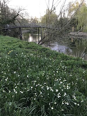
The Loddon Lily is named after the River Loddon. Its scientific name is Leucojum aestivum. It is also called Summer Snowflake. It is not a true lily, but part of the daffodil family, Amaryllidaceae. This plant grows from a bulb and likes heavy clay soils. It looks a bit like a large snowdrop. It grows well in wet meadows and along river banks.
After the flowers bloom, they produce fruits with large, black seeds. These seeds have special parts that help them float. When the river floods, the strong water can break the flower stalks. This lets the floating fruits be carried downstream. They can then get stuck on river banks, and the seeds can grow in new places. The bulbs themselves can also be moved by floods. This helps the plant spread in new locations.
Even though there are fewer Loddon Lilies now, you can still find them along the River Loddon. They are mostly near Sandford Mill.
Site of Special Scientific Interest (SSSI)
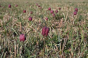
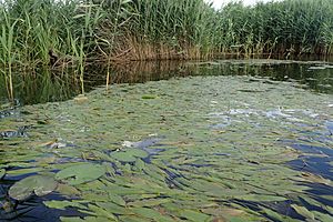
A 2.5-mile (4.0 km) part of the Loddon near Stanford End Mill is a special protected area. It is called a Site of Special Scientific Interest (SSSI). This area also includes nearby hay meadows that get wet often. The Loddon has been part of this SSSI since 1986. The meadows are cut for hay in July. Then, cattle graze there until the end of the year. This helps a flowering bulb called the snake's head fritillary (Fritillaria meleagris) to grow. It likes damp meadows that are not cut too often. The river is included in the SSSI because it has a main population of Loddon pondweed (Potamogeton nodosus).
Fish Life and River Improvements
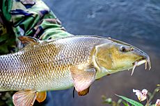
The River Loddon has many types of fish. These include shoals of bream, chub, roach, rudd, and large barbel. The biggest barbel caught in the river weighed 18 lb 1 oz (8.19 kg) in 2008. Other record catches include a 17 lb 12 oz (8.05 kg) pike in 1995 and a carp of the same weight in 2002.
To help fish move freely, a special bypass was built around weirs at Arborfield in 2010. This project cost £485,000. It was a joint effort by the Environment Agency, Thames Water, the University of Reading, and others. The bypass is 220-yard (200 m) long. It created new habitats, including 88 yards (80 m) suitable for fish to lay eggs. This helps fish like salmon, sea trout, eels, and barbel. The project also fixed four of the five weirs at Arborfield. This lowered the water level in the 2.8-mile (4.5 km) section above, which helps reduce flooding.
In 2018, work began to improve the river near Sandford Mill for fish. In the past, dredging made the water flow slowly. This caused silt to build up on the riverbed. To fix this, trees were cut down to let in more light. The wood was used to create flow deflectors. Also, 80 tonnes of gravel were added. This makes the water flow faster and stops silt from building up. Fast-flowing, shallow areas called riffles create places for dace, chub, and barbel to lay eggs. A dug-out backwater called Redlands helps protect young fish from being washed away during floods.
The lower part of the Loddon was used for recreational boating. Old maps show boat houses along many parts of the river. There were two on the Arborfield estate, and one still exists. There was also one near Mill Lane at Sindlesham, and another at Woodley. Old postcards show people using punts at Twyford and rowing boats at Sindlesham Mill and Arborfield Hall. The The George pub in Winnersh used to rent out rowing boats. There were about eleven boathouses on the river around the 1900s.
Lady Constance Russell wrote in 1901 that Sir Henry Russell, who owned Swallowfield Park, filled in a canal. This canal ran from the Lock Pool to the Bow Bridge. Maps from 1790 and 1817 clearly show this canal. Another piece of evidence for river use is the death of John Alfred Dymott in 1917. He drowned after falling out of a punt while moving materials. He often helped the estate carpenter move wood on the river.
Places of Interest Along the Loddon
| Point | Coordinates (Links to map resources) |
OS Grid Ref | Notes |
|---|---|---|---|
| Mouth of River Loddon | 51°30′06″N 0°52′49″W / 51.5017°N 0.8803°W | SU778786 | By Shiplake Lock |
| Junction with St Patricks Stream | 51°29′29″N 0°52′53″W / 51.4914°N 0.8814°W | SU777775 | |
| Site of Twyford Mill | 51°28′41″N 0°52′20″W / 51.4780°N 0.8723°W | SU784760 | |
| Sandford Mill | 51°27′04″N 0°52′40″W / 51.4511°N 0.8779°W | SU780730 | |
| A329 Loddon Bridge | 51°26′16″N 0°54′02″W / 51.4377°N 0.9006°W | SU765715 | An early bridge collapsed during construction |
| Sindlesham Mill | 51°25′38″N 0°53′51″W / 51.4273°N 0.8975°W | SU767703 | |
| Arborfield Mill | 51°24′29″N 0°55′28″W / 51.4081°N 0.9244°W | SU749682 | |
| Junction with River Blackwater | 51°23′07″N 0°57′31″W / 51.3854°N 0.9585°W | SU725656 | |
| Site of Lilly Mill | 51°19′39″N 1°01′57″W / 51.3274°N 1.0326°W | SU675591 | |
| Longbridge Mill | 51°19′07″N 1°01′15″W / 51.3187°N 1.0207°W | SU683581 | |
| Basingstoke Lower Mill | 51°16′47″N 1°02′33″W / 51.2797°N 1.0424°W | SU668538 | |
| Bartons Mill | 51°16′24″N 1°03′11″W / 51.2732°N 1.0530°W | SU661530 | (Old Basing Mill) |
| Basingstoke Upper Mill | 51°15′57″N 1°03′48″W / 51.2658°N 1.0633°W | SU654522 | |
| Festival Place | 51°15′58″N 1°05′11″W / 51.2660°N 1.0864°W | SU638522 | river culverted |
| Source | 51°15′50″N 1°07′26″W / 51.2638°N 1.1239°W | SU612519 | near West Ham Farm |
 | Emma Amos |
 | Edward Mitchell Bannister |
 | Larry D. Alexander |
 | Ernie Barnes |


