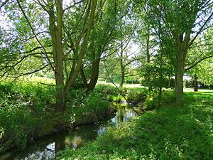
Emm Brook facts for kids
The Emm Brook is a small river in the English county of Berkshire. It is sometimes called the Embrook. This river flows into the River Loddon. They meet near the village of Hurst.
The Wokingham area of Emmbrook is named after this river. The Emm Brook flows through Dinton Pastures Country Park. Its path was changed there in the 1970s. This was done to allow for gravel to be dug out. The river also runs along the edge of The Emmbrook School.
Contents
What Happened During the 2007 Flood?
On July 20, 2007, the Emm Brook had a flash flood. A flash flood is a very sudden flood. The river's banks overflowed, especially near Emmbrook School. This flood damaged the ground floor rooms at the school. It also ruined the computer suites. The school had to rebuild these areas completely. This work was done during the summer holidays.
How Healthy is the Emm Brook's Water?
The Environment Agency checks the water quality of rivers in England. They give each river an overall health rating. This rating can be high, good, moderate, poor, or bad. They look at different things to decide this.
What is Ecological Status?
One part of the rating is called ecological status. This looks at the living things in the river. Scientists check the types and numbers of tiny creatures called invertebrates. They also look at flowering plants and fish. This helps them see how healthy the river's ecosystem is.
What is Chemical Status?
Another part is chemical status. This checks for different chemicals in the water. Scientists compare the amount of chemicals to safe levels. The chemical status is either good or fail.
Emm Brook's Water Quality in 2019
In 2019, the Emm Brook's water quality was checked.
- Its ecological status was moderate. This means it was okay, but not super healthy.
- Its chemical status was a fail. This means there were too many chemicals in the water.
- Overall, the river's health status was moderate.
The Emm Brook is about 14.5 kilometers (9 miles) long. Its catchment area is about 42.4 square kilometers (16.4 square miles). The catchment area is all the land where rain drains into the river.
 | Bayard Rustin |
 | Jeannette Carter |
 | Jeremiah A. Brown |


