
Barkham Brook facts for kids
Quick facts for kids Barkham Brook |
|
|---|---|
.jpg)
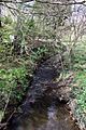
Barkham Brook looking downstream from the B3030 road bridge at Barkham
|
|
| Country | England |
| Counties | Berkshire |
| Districts / Boroughs | Wokingham Borough |
| Physical characteristics | |
| Main source | Finchampstead 51°23′18″N 0°51′28″W / 51.3884°N 0.8578°W |
| River mouth | River Loddon Winnersh 51°25′32″N 0°53′52″W / 51.4256°N 0.8977°W |
The Barkham Brook is a small river in the English county of Berkshire. It starts as small streams north and west of Finchampstead in the Wokingham Borough. The brook then flows past the village of Barkham. Finally, it joins the River Loddon west of Winnersh.
Contents
Journey of the Barkham Brook
The Barkham Brook begins as several small streams in a wooded area called The Moors. This area is north of Finchampstead, near the Sand Martins Golf Course. More small streams join it as it flows west. It then goes under Nash Grove Lane.
Historic Sites Along the Brook
As the brook nears Barkham, another stream joins it from the left. This stream comes from a network of small waterways west of Finchampstead. The brook then flows past an old moated site. A moat is a deep, wide ditch, often filled with water, built around a castle or house for protection. This moated site is a scheduled monument, which means it's a very important historical place.
Near the moat is the church of St. James. This church is a Grade II listed building, meaning it's historically important. The main part of the church was built in 1862. Inside, you can see a wooden statue of a woman from the 13th century. The brook flows under Barkham Street in Barkham. Here, another stream joins it from the left, flowing north from California.
The California Tributary and Longmoor Bog
This joining stream starts at Longmoor Lake. This lake covers about 6 acres and is part of California Country Park. A man named John Walter III created the lake in 1873. He used the clay from digging the lake to make bricks. In the 1930s, this area became a holiday camp called California-in-England. It even had a speedway track! Today, it's a Country Park.
The water flowing out of Longmoor Lake goes through Longmoor Bog. This bog is a special place called a Site of Special Scientific Interest (SSSI). It's important because it's one of the few "base-poor" valley mires in Berkshire. This means the soil is acidic, and it has a unique mix of plants. The bog also has wet heathland, where peat sits on clay. This creates a reddish swamp because of iron bacteria. You can find trees like alder and willow around the bog. The swamp itself has plants like purple moor grass.
From Arborfield to Bearwood Lake
At the edge of Longmoor Bog, the brook goes under Park Lane. It then turns north, flowing along the edge of the former Arborfield Garrison. This used to be a military base but is now being redeveloped for homes. After passing under Biggs Lane, the brook flows into another lake. It then crosses open fields before joining the main channel of Barkham Brook.
The combined stream continues north and goes under the B3349 Barkham Road. Another stream joins it here, flowing west from the lakes at Barkham Manor. Barkham Manor is a Grade II listed manor house. It was built in the 1600s on a moated site. It was once home to John Walter, and Mary Ball Washington, the mother of George Washington, was born there.
The brook continues northwest. Water from the Arborfield Sewage Treatment Works also flows into it. In 2013, there was an incident where untreated water was released, which harmed fish and plants. The company responsible was fined for this.
Bearwood Lake and the Brook's End
West of the treatment works, the brook turns north. It flows under the B3030 Mole Road at Mole Bridge Farm, where there's a small waterfall called a weir. Soon after, water from Bear Wood Lake joins the brook. Bear Wood Lake is part of the beautiful Grade II* listed parks and gardens of Bearwood College.
John Walter II bought the Bearwood Estate in the early 1800s. He made the lake much bigger, to about 49 acres. His son, John Walter III, rebuilt the main house. The lake was created by building a strong clay wall, called a dam, across a small stream. Water from the lake used to power a sawmill nearby. Today, water is pumped from the lake to water the golf course. Because the dam holds a lot of water, it's checked regularly for safety.
Water from Bearwood Lake normally flows out through a concrete spillway. This water travels in a ditch, goes under Mole Road, and then through a pipe to join Barkham Brook. The brook continues northwest. It almost reaches the River Loddon, but then turns northeast. It flows under the M4 motorway through its own tunnel. After running next to the Loddon for a short distance, Barkham Brook finally joins the River Loddon on its right side, just below the weir at Sindlesham watermill.
Water Quality of Barkham Brook
The Environment Agency checks the water quality of rivers in England. They give each river an overall "ecological status." This status can be high, good, moderate, poor, or bad. They look at things like the types of bugs, plants, and fish living in the water. They also check the "chemical status," which means they test for different chemicals to make sure they are at safe levels. Chemical status is either "good" or "fail."
In 2019, the water quality of Barkham Brook was:
| Section | Ecological Status |
Chemical Status |
Overall Status |
Length | Catchment |
|---|---|---|---|---|---|
| Barkham Brook | Moderate | Fail | Moderate | 4.8 miles (7.7 km) | 7.23 square miles (18.7 km2) |
The main reasons why the water quality is not "good" are discharges from sewage treatment works. Also, changes made to the river channel, often for land drainage, make it harder for fish to move around.
Images for kids
-
Barkham Brook looking downstream from the B3030 road bridge at Barkham
