
Bow Brook, Hampshire facts for kids
Quick facts for kids Bow Brook |
|
|---|---|
.jpg)
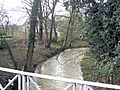
Bow Brook looking upstream from the iron bridge dated 1831 at Beaurepaire Mill.
|
|
| Country | England |
| Counties | Hampshire |
| Physical characteristics | |
| Main source | Ramsdell 51°18′31″N 1°09′39″W / 51.3087°N 1.1609°W |
| River mouth | River Loddon Sherfield on Loddon 51°19′32″N 1°01′55″W / 51.3256°N 1.0319°W |
| Basin features | |
| Tributaries |
|
Bow Brook is a small river in Hampshire, England. It flows into a bigger river called the River Loddon. Its journey starts with small streams near Ramsdell and Sherborne St John. After winding through the countryside, it meets the Loddon near Sherfield on Loddon. Long ago, this river was powerful enough to run at least two watermills!
Contents
The River's Journey
Bow Brook begins as several small streams west of Pamber End. Some parts are called "drains," which means they might have been built or changed by people. One stream starts near West Heath and flows under two roads. Another starts further south and joins the first one.
These streams flow east, passing the northern edge of Pamber Priory. A third stream starts from three ponds west of Ramsdell. It is joined by two more streams before flowing under Brocas Bridge. This stream then runs along the south and east sides of the priory.
Pamber Priory: A Historic Stop
Pamber Priory was a special kind of monastery. It was founded around 1130 by Henry de Port during the time of King Henry I. It was an "alien priory," meaning it was controlled by a foreign monastery in Normandy, France.
Because it was under foreign control, it was closed down in 1446. Eventually, the land became part of The Queen's College, Oxford, which still owns it today. Parts of the old priory church, built in the 1100s and 1200s, are still standing. They are now called the Priory Church of the Holy Trinity, Our Lady, and St John the Baptist. This church is a very important historic building, listed as Grade I. The nearby farmhouse and barn are also historic, listed as Grade II.
Through Woods and Past Old Roads
Another stream from Monk Sherborne Wood flows north to join the main river. This happens as it passes under the A340 Aldermaston Road. After the bridge, the river flows through pretty woodlands like Pamderend Gully Copse.
More small streams join the Bow Brook here. One starts from a spring in Cranes Copse. This area was also where a Roman road once crossed the river! Further on, a stream called Old Ponds joins from the north. It starts near Pamber Green and flows under bridges like Little Loddon and Boar's Bridge.
The river then continues through more woods. It flows over a small waterfall called Tumbling Bay before reaching Beaurepaire Mill.
Beaurepaire Mill and Iron Bridge
The main mill building at Beaurepaire was built in the 1870s or 1880s. It was part of the Beaurepaire estate but is now a house. The larger mill house was built around the same time.
The river then flows under a very old bridge from 1831. This bridge is special because it's made of five strong cast-iron beams. It has fancy wrought-iron railings and brick supports.
Bramley Training Area and Ancient Fort
Soon after, the river crosses another old Roman road. It then goes under Lock's Bridge and enters the Bramley Training Area. This area used to be a big storage place for ammunition from 1917 to 1987.
The river splits into two parts here, then joins back together. Both parts flow under the Great Western Railway line, which connects Basingstoke and Reading. The old ammunition depot even had its own railway lines that crossed Bow Brook several times!
The Brook then curves around a hill where an ancient Iron Age fort called Bulls Down Camp once stood. This fort covered about 10 acres and has never been dug up by archaeologists. It's now a protected historic site. The river then flows along the edge of Sherfield on Loddon and passes a sewage treatment works before finally joining the River Loddon.
Vyne Stream: A Key Tributary
Vyne Stream is an important stream that flows into Bow Brook. It starts from springs in the south-east of Sherborne St John. It flows under Vyne Road and forms a large pond called Mill Head.
Another stream, Wey Brook, also feeds into Mill Head. It starts from springs near the A340 road. Wey Brook used to supply water to watercress farms. Its outflow also powered a watermill.
The Vyne Estate
After the mill, Vyne Stream turns north and enters The Vyne. This is a large parkland area that had a manor house and chapel as early as 1362. In 1496, William Sandys inherited it. He became a very important person to King Henry VIII. Much of the park became part of the estate around that time.
In 1754, John Chute inherited the estate and probably made the lake bigger. In 1956, the estate was given to the National Trust. It includes 10 hectares of gardens, 35 hectares of parkland, and 55 hectares of woodland.
At the south end of the lake, there's a beautiful three-arched bridge built in 1840. It's made of red bricks with cast-iron railings. At the end of the lake, there's a weir and a smaller lake. Vyne Stream then flows north under Morgaston Road to reach the mill pond at Beaurepaire Mill.
Watermills and History
People have used Bow Brook and its streams to power mills for a very long time. Records from the Domesday Book in 1086 show that there were three mills in Sherborne St John. One of these was probably where Beaurepaire Mill is today.
This mill was given to Monk Sherborne Priory when it was founded in 1130. The priory received money from the mill every year. They also got their corn ground for free!
In 1302, records mention two mills and a fishpond in Sherborne St John. One was at the site of the current Beaurepaire Mill. The other was likely on the Wey Brook. Beaurepaire Mill appears on a map from 1613. Both Beaurepaire Mill and Sherborne St John Mill were still grinding corn in the early 1900s. Beaurepaire Mill was later turned into a house in the 1870s.
River Health: Water Quality
The Environment Agency checks the water quality of rivers in England. They give each river an "ecological status" rating: high, good, moderate, poor, or bad. This rating looks at things like:
- Biological status: How many and what kinds of invertebrates (like insects), plants, and fish live there.
- Chemical status: How much of different chemicals are in the water compared to safe levels. This is rated as "good" or "fail."
Here's how Bow Brook's water quality was in 2019:
| Section | Ecological Status |
Chemical Status |
Overall Status |
Length | Catchment |
|---|---|---|---|---|---|
| Bow Brook (Pamber End to Bramley) | Poor | Fail | Poor | 9.0 miles (14.5 km) | 6.97 square miles (18.1 km2) |
| Vyne Stream | Moderate | Fail | Moderate | 4.6 miles (7.4 km) | 4.88 square miles (12.6 km2) |
| Bow Brook (Bramley to Sherfield Green) | Moderate | Fail | Moderate | 3.4 miles (5.5 km) | 3.75 square miles (9.7 km2) |
The water quality is not as good as it could be for a few reasons. These include:
- Water from sewage treatment plants.
- Things that block fish movement, like changes made to the river for drainage or mills.
- Water running off from farms.
- Vyne Stream is also affected by taking too much water from underground sources.
- The presence of an invasive animal called the North American signal crayfish.
Images for kids
-
Bow Brook looking upstream from the iron bridge dated 1831 at Beaurepaire Mill.
