
Basingstoke Canal facts for kids
Quick facts for kids Basingstoke Canal |
|
|---|---|

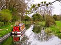
The Basingstoke Canal passing through Woking
|
|
| Specifications | |
| Length | 31 miles (50 km) |
| Maximum boat length | 72 ft 6 in (22.10 m) |
| Maximum boat beam | 13 ft 6 in (4.11 m) |
| Locks | 29 |
| Status | Partially open |
| Navigation authority | The Basingstoke Canal Authority |
| History | |
| Principal engineer | John Smeaton |
| Other engineer(s) | Benjamin Henry Latrobe |
| Date of act | 1778 |
| Date completed | 1794 |
| Date closed | 1932 |
| Date restored | 10 May 1991 |
| Geography | |
| Start point | Byfleet |
| End point | Greywell (originally Basingstoke) |
| Connects to | Wey Navigation |
The Basingstoke Canal is a British canal. It was finished in 1794. It was built to link Basingstoke with the River Thames. Boats could reach the Thames at Weybridge. This was possible by using the Wey Navigation.
The canal starts near Basingstoke. It goes through or close to places like Greywell, Odiham, Fleet, and Woking. Its eastern end is at Byfleet. Here, it connects to the Wey Navigation. This river then leads to the River Thames. The canal's main goal was to let boats travel from London docks to Basingstoke.
The canal was not very successful for business. By 1950, it was not looked after. It became very run down. People started working to fix it in 1977. On May 10, 1991, the canal reopened. It was fully open from the River Wey almost to the Greywell Tunnel. However, its use is still limited today. This is due to low water and rules to protect nature.
Contents
History of the Basingstoke Canal
The idea for the canal was to help farming in Hampshire. A law was passed in 1778. But it was hard to get enough money. So, building did not start until October 1788. It was finished on September 4, 1794.
Engineers John Smeaton and William Jessop worked on the canal. Benjamin Henry Latrobe also helped. One main thing carried from Basingstoke was timber.
In 1831, people planned a railway from London to Southampton. The canal company suggested linking the canal to the Itchen Navigation. But this idea was turned down. The canal company then agreed not to stop the railway.
The canal never made much money. It stopped being used even before the London and South Western Railway was built. This railway runs next to the canal. Commercial use ended in 1910. But people still used the canal a little.
In 1913, Alec Harmsworth tried to sail the canal. His boat was called Basingstoke. He wanted to keep the canal open. A law from 1778 said if the canal was not used for 5 years, the land would go back to its old owners. He could not sail the whole canal. But it was not closed down.
During World War I, the Royal Engineers took over the canal. They used it to move supplies from Woolwich. Soldiers also learned how to handle boats there.
Harmsworth bought the canal in 1922. He ran some boats on it. They carried goods a little and were used for fun trips. After he died in 1947, the canal was sold. By 1950, a new company owned it. This company tried to fix the canal. But there were problems in 1957 and 1968. By the late 1960s, it was mostly ruined. This was despite volunteers trying to help.
Restoring the Basingstoke Canal

In 1966, a group of local people formed the Surrey and Hampshire Canal Society. It is now called the Basingstoke Canal Society. They wanted to reopen the old canal. They worked hard to get the county councils of Hampshire and Surrey to buy the canal in 1976.
In February 1977, a project started to create jobs. Its goal was to fix the Deepcut flight of locks. This work was done with the canal society. Volunteers worked on weekends. The job creation team worked during the week.
After about 18 years of hard work, 32 miles (51 km) of the canal reopened. This happened on May 10, 1991. The western part, from North Warnborough to Basingstoke, cannot be used by boats. This is because it enters the Greywell Tunnel. The tunnel partly fell in 1932. It is now home to a protected bat colony. So, it is unlikely the tunnel will ever be fixed. Some of the old canal area in Basingstoke is now covered by new buildings.
The Basingstoke Canal Authority now manages the canal. It is open for boats all year. Locks have limited opening times. This is because there is not much water. They try to stop summer closures. Boat numbers are also limited to 1300 per year. This is because most of the canal is a Site of Special Scientific Interest. This means it is a special place for nature.
East of the middle point, large areas of heathland are around the canal. These are homes for reptiles like vipers and lizards. Birds like nightjars, woodlarks, and Dartford warblers also live there. Much of this heathland is still here. This is because it was used for military training since the late 1800s.
There is a visitor center for the canal at Mytchett. You can find information there.
Special Nature Areas on the Canal
Two parts of the canal are very special for nature. They cover 101.3 hectares (250 acres). They are called a Site of Special Scientific Interest. These are the main part between Greywell and Brookwood Lye. Also, a short part between Monument Bridge and Scotland Bridge in Woking.
This canal area has the most different kinds of plants in England. Rare plants like hairlike pondweed and tasteless water-pepper grow here. The site is also important for its insects. There are 24 types of dragonflies. Other rare insects are also found here.
Lost Parts of the Basingstoke Canal
The canal used to start in the middle of Basingstoke. But the last 5 miles (8 km) of the canal are now gone. This part of the canal stopped being used. This was after the Greywell Tunnel closed. There were no boats, it was not cared for, and there was not enough water.
There were no locks on this part of the canal after Ash. So, it mostly followed the land's shape. It had some cut-throughs, tunnels, and raised banks. You can partly see its path on old maps. The canal was between the 75 m and 80 m height lines.
The main water for the Basingstoke end came from springs in the Greywell Tunnel. Old maps show the River Loddon next to the canal in Basingstoke, but not flowing into it. Also, a visit to Eastrop Way shows it is now higher than the nearby River Loddon. There is no water link from a spring near Hatch. However, small streams flow into the canal at Fleet and Aldershot.
People tried to get more water. A small lock was built east of the Greywell tunnel. It raised the water level by about 30 centimetres (1 ft). But this was a long section with many raised banks. This was likely a cheap, short-term fix. It was to keep the canal open instead of fixing leaks.
The canal started at a basin. This is roughly where the cinema in Festival Place is now. From there, it ran next to the River Loddon. It followed the path of Eastrop Way. The old canal path goes under the ring road. Then it follows a long loop on a raised bank. This goes over small streams and wet fields towards Old Basing.
The path goes around the ruined Basing House palace. Then it goes through and around the eastern edge of Old Basing. Parts of the canal that were cut into the ground hold water in winter. These are in Old Basing, near Milkingpen Lane. Also, a section runs around farmland behind the Belle View Road estate.
It followed another loop to go over small streams near the Hatch public house. Much of this part was built over when the M3 motorway was made. It then went across fields on a raised bank towards Mapledurwell. The canal then went towards a small tunnel under the Andwell Drove. Then it went across another field, partly on a raised bank, towards Up Nately.
The part of the canal from Up Nately to the Greywell Tunnel's western entrance still exists. It is a nature reserve. There is water in the canal. You can walk the canal towpath. A path at the tunnel's western entrance lets walkers reach public paths to the tunnel's eastern entrance.
Boats can go about 500 m east of the Greywell Tunnel. This is towards North Warnborough. The section to the tunnel entrance can probably be used by canoes. The fixed parts of the canal can then be used by boats going east.
The Basingstoke Canal Heritage Footpath follows the canal path. It is about 2 miles (3 km) long. It goes from Festival Place to Basing House.
People have often talked about linking Basingstoke to the canal again. This is still a long-term goal for the Basingstoke Canal Society.
Another idea was to link the canal to the Kennet and Avon Navigation near Reading. This link was suggested three times between 1793 and 1810. A route was even checked by John Rennie in 1824. But landowners did not like the idea. So, Parliament rejected it in 1824 and 1826.
The Basingstoke Canal Authority
Hampshire County Council and Surrey County Council own the canal. Each council owns the part in its area. Before 1990, each council managed its own section. Then, they decided one group should manage the whole waterway. So, the Basingstoke Canal Authority was created.
In 1993, the canal visitor center opened. This is now the main office for the Canal Authority.
Hampshire County Council employs and supports the Canal Authority staff. But the visitor center belongs to Surrey County Council. Both County Councils give money to the Canal Authority. Six local district councils along the canal also help. The Canal Authority is guided by a special committee. This committee has members from each local council partner.
The way the Canal Authority works was last reviewed in 2011. The two County Councils now have officers who guide the canal's plans. They took over some of the old Canal Director's job. The Canal Authority now has a canal manager, an administration officer, a visitor services manager, and an officer. A team of five canal rangers and one senior ranger maintain the canal. A part-time lock keeper also helps.
Interesting Features Along the Canal

A special thing about the canal is the many concrete bunkers. These are called pillboxes. You can still see them along the canal. They were built during World War II. They were part of the GHQ Line. This line was to defend against a German invasion.
Odiham Castle is at the Basingstoke end of the canal. The canal runs through part of the castle's old grounds.
The Greywell Tunnel is no longer used. It is 1,230 yards (1,120 m) long. It was the 12th longest canal tunnel in Great Britain.
Gallery
-
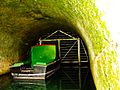
Inside the Greywell Tunnel (east end)
-

The eastern entrance of Greywell Tunnel
-
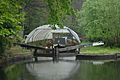
View from the 'Lift Bridge' in North Warnborough
-
Basingstoke Canal Centre, Mytchett, Surrey
-
Guildford Road Bridge, Basingstoke Canal, Frimley Green, Surrey
-
Dry dock
-
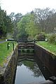
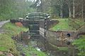
A lock
-
Repairs being carried out in 2012


