
River Wey facts for kids
Quick facts for kids River Wey |
|
|---|---|

Elstead Bridge, originally built by the monks of Waverley Abbey
|
|

Map of the River Wey (dark blue),
also showing part of the River Thames (light blue) and canal sections of the Wey and Godalming Navigations (green). |
|
| Country | England |
| Counties | |
| Districts / Boroughs | Chichester (district), East Hampshire (district), Waverley, Guildford, Woking, Elmbridge, Runnymede |
| Towns | Alton, Haslemere, Farnham, Godalming, Guildford, Weybridge |
| Physical characteristics | |
| Main source | spring Alton, East Hampshire, Hampshire 109 metres (358 ft) 51°08′42″N 0°59′42″W / 51.145°N 0.995°W |
| 2nd source | pond Black Down, West Sussex, Chichester, West Sussex 199 metres (653 ft) 51°03′32″N 0°42′00″W / 51.059°N 0.700°W |
| River mouth | River Thames Weybridge, Elmbridge, Surrey 12 metres (39 ft) 51°22′48″N 0°27′22″W / 51.380°N 0.456°W |
| Length | 140 km (87 mi) |
| Discharge (location 2) |
|
| Discharge (location 3) |
|
| Discharge (location 4) |
|
| Basin features | |
| Progression | Wey (north branch), Wey, Thames Wey (south branch), Wey, Thames |
| River system | Thames Basin |
| Basin size | 904 km2 (349 sq mi) |
| Tributaries |
|
The River Wey is a major river in south east England. It flows into the famous River Thames. The Wey has two main parts, called branches. One branch starts near Alton in Hampshire. The other begins in West Sussex, south of Haslemere. These two branches meet up at a place called Tilford in Surrey.
After they join, the river flows east, then turns north. It passes through towns like Godalming and Guildford. Finally, it reaches the River Thames at Weybridge. Along its path, the river flows past historic sites like Newark Priory and Brooklands. In the 1600s and 1700s, parts of the river were made deeper and wider. This created the Wey and Godalming Navigations, allowing boats to travel from Godalming all the way to the Thames.
The River Wey collects water from a large area. This area is called its catchment area, and it covers about 904 square kilometers (349 square miles). Even though the Wey is one of the longest rivers that flows into the Thames, it carries less water on average than some other rivers like the Kennet. Scientists study the river's shape and the different plants and animals that live in and around it. The Tillingbourne is an important smaller river that flows into the Wey. It starts on the slopes of Leith Hill and joins the Wey south of Guildford.
The name 'Wey' has been used for a long time, but its exact meaning is not known.
Contents
The River Wey's Journey
The River Wey starts in two different places and then joins together. Let's explore where each part begins and how they flow.
The North Branch of the Wey

The north branch of the Wey is sometimes called the Alton Wey. It officially starts in Alton, in Hampshire. However, a nearby stream called Caker Stream is actually longer. This stream collects water from fields near Upper Farringdon and Hartley Mauditt. It flows through Chawton before joining the main north branch in Alton.
After Alton, the river flows mostly east-northeast through Upper Froyle and Bentley. It then turns southeast as it gets closer to Farnham, heading towards Tilford. As the river enters Surrey, its valley becomes steeper. The valley was formed as the river wore away soft rock. It changes from a V-shape to a U-shape, creating a flatter area where the river flows.
Long ago, the upper part of this branch was actually part of a different river system, the River Blackwater. Over time, floods and deposits of earth caused the Wey to "capture" this part of the Blackwater's path. This means the Wey started flowing where the Blackwater used to. You can still see signs of this, like special gravels that were carried by the older river.
The South Branch of the Wey
The south branch of the Wey also starts from several smaller streams. Two main streams flow westwards. One of these streams now runs alongside the Portsmouth Direct Line railway. The other, which has longer starting points, follows the border between Surrey and Sussex. These streams meet where the railway line gets very close to the county border.
These streams are fed by six smaller waterways. The ones furthest south drain narrow valleys between hills like Blackdown (one of the highest hills in southeast England), Ridge Hill, Fridays Hill, and Marley Heights. The northern streams drain parts of a ridge called Greensand. These include areas like Wey Down, Inval, Stoatley Rise, and Brownscombe. These are long, sandy hills southeast of the Devil's Punch Bowl.
The very start of the south branch is in places like Kingsley Green (a wooded area in Fernhurst), Chase Farm (the southernmost point in Surrey), and fishponds at Wades Marsh (on the border of Fernhurst and Lurgashall in West Sussex).
The south branch flows through the western parts of Haslemere, then Liphook, Bramshott, Standford, Lindford, and the large area of Frensham. It then joins the north branch at Tilford. In this area, all three parts of the river have large bends, called meanders. Important smaller rivers that join the south branch include Cooper's Stream and the River Slea.
The Combined River's Path
After the two branches meet at Tilford, the River Wey continues its journey. It flows through towns and villages such as Elstead, Eashing, Godalming, Peasmarsh/Shalford, Guildford, Send, Old Woking, Pyrford, Byfleet, and New Haw.
Near Addlestone and Weybridge, the river forms the border between these areas. From Godalming onwards, the river is closely connected with the Wey and Godalming Navigations. These are parts of the river that were made wider and deeper for boats. The path next to the navigations, called the towpath, is about 20 miles long and is open for people to walk on. The River Wey finally joins the River Thames at Weybridge.
Smaller Rivers Joining the Wey
Several smaller rivers, called tributaries, flow into the Wey:
- The River Ock joins the Wey at Godalming.
- Cranleigh Waters and the River Tillingbourne meet the Wey at Shalford.
- The Hoe Stream flows into the Wey at Woking.
History of the River Wey
The River Wey has been important to people for a very long time.

People have used the river's power to run mills for centuries. The Domesday Book, a very old record from 1086, mentions many mills along the Wey. Between the 1600s and 1800s, there were over 40 mills on the river and even more on its smaller streams. These mills were used for many things, like grinding grain for flour, processing wool, making paper, and even producing gunpowder. Some mills, like Willey Mill in Farnham, were still working in the 1950s. Headley Mill is still used for business today. Guildford Town Mill no longer grinds grain, but it still uses the river's power to make electricity.
In the 1600s, the river was made suitable for boats to travel as far as Guildford. In the 1700s, this boat route was extended to Godalming. Later, other canals like the Basingstoke Canal and the Wey and Arun Junction Canal were connected to the River Wey. Today, the parts of the river that boats can use are owned by the National Trust, a charity that protects historic places and natural spaces.
The River's Natural Environment
The area around the River Wey, especially where it narrows before joining the Thames, is often called the Wey Valley.
Much of the upper part of the river flows through the Surrey Hills Area of Outstanding Natural Beauty. This means it's a special place with beautiful landscapes. The river flows through many different natural areas, including open heathland, thick woodlands, and wet meadows. This variety of habitats means many different kinds of plants and animals live there. Along the river, you can find special protected areas called Sites of Special Scientific Interest (SSSI) and Nature Reserves.
The land around the river slopes steeply, and a lot of water drains into it. In the past, this meant that the flat areas next to the river, called floodplains, would often flood. However, efforts to control flooding, like building lakes upstream (such as Frensham Great Pond) and the Wey navigations, have greatly reduced this. Even with these measures, some lower areas in Godalming, Byfleet, and Weybridge experienced significant flooding during very heavy storms in 2013–14.
River Water Quality
The Environment Agency checks the water quality of rivers in England. They give each river system an overall "ecological status," which can be high, good, moderate, poor, or bad. This status is based on several things. They look at the "biological status," which means checking the types and numbers of tiny creatures (invertebrates), flowering plants, and fish in the water. They also check the "chemical status," comparing levels of different chemicals to safe amounts. The chemical status is either "good" or "fail."
Here's how the water quality of different parts of the River Wey was rated in 2019:
| Section | Ecological Status |
Chemical Status |
Overall Status |
Length | Catchment | Channel |
|---|---|---|---|---|---|---|
| North Wey at Alton | Moderate | Fail | Moderate | 2.802 km (1.741 mi) | 54.231 km2 (20.939 sq mi) | Heavily modified |
| North Wey (Alton to Tilford) | Poor | Fail | Poor | 31.242 km (19.413 mi) | 82.531 km2 (31.865 sq mi) | |
| South Wey (Haslemere to Bordon) | Poor | Fail | Poor | 17.234 km (10.709 mi) | 40.382 km2 (15.592 sq mi) | |
| South Wey (Bordon to River Slea confluence) | Moderate | Fail | Moderate | 5.823 km (3.618 mi) | 11.342 km2 (4.379 sq mi) | |
| South Wey (River Slea confluence to Tilford) | Moderate | Fail | Moderate | 11.633 km (7.228 mi) | 38.999 km2 (15.058 sq mi) | |
| Wey (Tilford to Shalford) | Poor | Fail | Poor | 23.332 km (14.498 mi) | 63.274 km2 (24.430 sq mi) | |
| Wey (Shalford to River Thames confluence at Weybridge) | Moderate | Fail | Moderate | 46.346 km (28.798 mi) | 75.772 km2 (29.256 sq mi) | Heavily modified |
- Inland Waterways Association (South-East Region) The River Wey and Godalming Navigation: Weybridge to Godalming Inland Waterways Association 1976
Images for kids
-
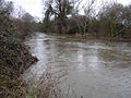
The River Wey near Pyrford, separate from the Wey Navigation, when it is full.

See Also
 In Spanish: Río Wey (Támesis) para niños
- Tributaries of the River Thames
- Canals of the United Kingdom
- List of rivers of England
- Perseverance IV, the last working barge on the River Wey.
- Mills on the River Wey and its tributaries
