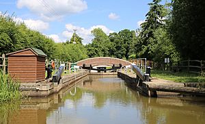
Wey and Arun Canal facts for kids
The Wey and Arun Canal is a 23-mile-long (37 km) canal in the southeast of England. It connects the River Wey in Gunsmouth, Shalford, Surrey to the River Arun at Pallingham in West Sussex. This canal is actually made up of two older waterways. The northern part was the Arun Navigation, which opened in 1787. The southern part was the Wey and Arun Junction Canal, which opened in 1816.
The canal passed through mostly countryside areas. This meant there wasn't much heavy cargo to transport. Because of this, the canal was officially closed in 1871. Without regular care, it slowly fell apart over many years.
However, since 1970, a group called The Wey & Arun Canal Trust has been working to fix it. They have already restored several miles of the canal. Now, narrowboats and small tour boats can use these parts. The trust is still working hard, hoping to reopen the entire canal someday.
Contents
People used the River Arun for travel and trade for hundreds of years. By 1575, boats could reach Pallingham Quay. In 1785, a special law was passed to improve the river. This law allowed for changes to make the river easier to navigate.
The new route included a man-made channel, about 4.5 miles (7.2 km) long. This channel crossed the river using a special bridge called an aqueduct. This aqueduct had three strong brick arches.
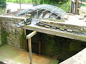
It was finished in 1787. A unique waterwheel was built into the aqueduct at Lordings Lock. This wheel was powered by the river's flow. It had scoops that lifted water from the river into the canal.
In 1790, a shortcut was added from Coldwaltham to Stopham. This shortcut included a 375-yard (343 m) tunnel under Hardham Hill. This saved boats about 5 miles (8 km) of travel.
The route from Newbridge down to Houghton was about 13 miles (21 km) long and had six locks. The river then continued for another 15.5 miles (25 km) to the sea.
The last boat to use the section between Pallingham and Newbridge was in 1888. The Hardham tunnel closed in 1889. The man-made parts of the Arun Navigation were officially closed in 1896.
Wey and Arun Junction Canal: Connecting Two Rivers
People first thought about linking the Wey and Arun rivers way back in 1641. The tops of the two rivers were only about 2 miles (3.2 km) apart. A plan for a canal was even presented to Parliament, but it didn't go through.
In 1810, a nobleman named the 3rd Earl of Egremont pushed the idea again. He wanted a canal to connect the two rivers, which were 15 miles (24 km) apart. This canal was important because England was at war with France. An inland route from London to Portsmouth would be safer than shipping goods along the coast.
Josias Jessop, a famous engineer's son, became the main engineer in 1811. He estimated the canal would cost about £72,217. He later increased this to £86,132 when the route was slightly changed.
A new law was passed on April 19, 1813. This law allowed the building of a canal to connect the River Wey and the River Arun. The canal would run from the Godalming Navigation (part of the River Wey) near Shalford to the Arun Navigation at Newbridge.
The canal was 18.5 miles (29.8 km) long and had 23 locks. It was built for barges that could carry 30 tons of goods. The construction finished in September 1816 and cost £103,000.
However, by the time the canal opened, the war with France was over. This meant one of the main reasons for building it was gone. So, the canal never made a lot of money. Its busiest year was 1839, when it carried 23,000 tons of goods.
But then, railways started to become popular. In 1865, the Guildford and Horsham Railway opened, which competed directly with the canal. The canal also had problems with not enough water. The ground was porous, meaning water leaked away easily.
In 1867, some tourists took a trip along the canal. Their journey was written about in a book. In 1868, another law allowed the canal to close. It was offered for sale in 1870 and officially closed in 1871.
Restoring the Wey and Arun Canal
After being unused for about 100 years, people started to get interested in restoring the canal. This interest grew after a book called London's Lost Route to the Sea was published in 1965.
In 1970, a group of local people formed the Wey & Arun Canal Society. They wanted to reopen the canal. This society later became The Wey & Arun Canal Trust in 1973. This trust now leads the restoration work.
By 2009, the Trust had made amazing progress. They had rebuilt twenty-four bridges. They also fixed eleven locks and two aqueducts. Many miles of the canal bed were cleared and cleaned.
The unique waterwheel at Lordings Lock was rebuilt in the early 2000s. In 2010, its main part broke, so the wheel was rebuilt again with a better design.
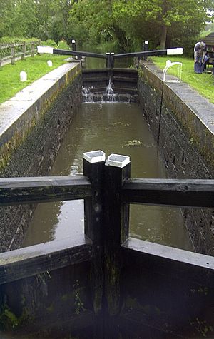
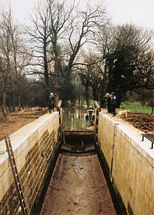
Restoration work has continued, moving northwards. Devil's Hole Lock (lock 6) was partly destroyed by the Canadian army in 1942 during a training exercise. It has been rebuilt and made longer for modern narrowboats. This lock reopened on April 17, 2010.
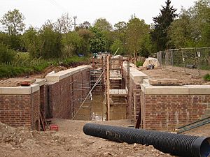
Southland Lock (lock 7) also needed a lot of work. Many of its original bricks were taken away in the 1930s. This lock reopened on June 21, 2014. Volunteers are now working on Gennets Bridge Lock (lock 8). This is a big project because almost nothing was left of the original lock.
Southland Lock is currently the furthest north you can go on the restored section. It's about 3 miles (4.8 km) from Drungewick Lock (lock 3) in the south.
The B2133 Bridge Project
The old hump-backed road bridge at Loxwood was removed and filled in around 1905. This cut the canal in half and was a big problem for restoration. The last boat passed under this bridge in 1869.
Modern rules meant a new hump-backed bridge couldn't be built. So, the canal had to go under the road, keeping the road at its normal level. This was a huge engineering challenge.
They lowered a 440-yard (402 m) section of the canal. This gave enough space for boats to pass under the road. At the southern end, Brewhurst Lock was rebuilt. Its drop was reduced from 8 feet (2.4 m) to just 2 feet (0.6 m). This lowered the water level in the canal section under the bridge.
At the other end, a new lock called Loxwood Lock was built. This lock handles the 6-foot (1.8 m) difference between the old and new canal levels. The canal bed in between was lowered by 4.5 feet (1.4 m). The banks were strengthened, and a new turning area for boats was made.
The new bridge crosses the canal at an angle. The 'tunnel' for the canal is 25 yards (23 m) long. The towpath (a path next to the canal) also goes through the tunnel. This lets people walk safely under the road. However, horse riders still have to cross at road level because the bridge is not tall enough for them.
The work was finished, and the first boat passed under the new bridge in April 2009. This project cost £1.8 million. It was one of the most expensive projects ever done by a volunteer canal trust. Lord Sterling of Plaistow officially opened it on May 9.
Some local people didn't like the design of the bridge, especially its steel barriers. After discussions and fundraising, permission was given to replace them. They were replaced with lower, brick-faced walls that matched the nearby lock.
The lock and footbridge won second place in a special award in 2010. This was a great achievement because the Trust was the only volunteer group to enter. The project, which cost £1.9 million, also won an award in 2011 for its community benefits.
 | Percy Lavon Julian |
 | Katherine Johnson |
 | George Washington Carver |
 | Annie Easley |


