River Arun facts for kids
Quick facts for kids Arun |
|
|---|---|

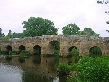
Stopham Bridge near Pulborough. The centre arch was raised in 1822.
|
|

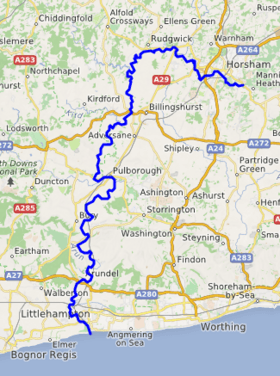
Course of the Arun
|
|
| Other name(s) | Tarrant |
| Country | England |
| County | West Sussex |
| Towns | Horsham, Arundel, Littlehampton |
| Physical characteristics | |
| Main source | St Leonard's Forest, West Sussex 125 m (410 ft) |
| River mouth | Littlehampton, West Sussex 0 m (0 ft) |
| Length | 60 km (37 mi) |
| Discharge (location 2) |
|
| Basin features | |
| Basin size | 376 sq mi (970 km2) |
| Tributaries |
|
| Protection status | |
| Official name: Arun Valley | |
| Designated: | 16 December 1999 |
| Reference #: | 1011 |
The River Arun is a river in the English county of West Sussex. It is about 37 miles (60 km) long. This makes it the longest river that stays completely within Sussex. It's also one of the longest rivers that start in Sussex.
The Arun begins as small streams in St Leonard's Forest. It flows west through Horsham and then turns south. It meets its main branch, the western River Rother. The river then goes through a gap in the South Downs to Arundel. Finally, it reaches the English Channel at Littlehampton. The River Arun is known for being one of the faster-flowing rivers in England. The tide affects it as far inland as Pallingham Quay. The river gives its name to the Arun local area in West Sussex.
People started improving the river for boats between the 1540s and 1570s. This helped Arundel become a port. Later, from 1732, special commissioners looked after the river from Arundel to the sea. They made big changes to stop the river mouth from getting blocked with mud. Over time, Littlehampton became the main port instead of Arundel. Today, the Littlehampton harbour commissioners still manage the river up to Arundel.
The river above Arundel was also improved after 1785. Two major shortcuts were built. One shortcut, near Pulborough, included a tunnel. Another shortcut near Newbridge used an aqueduct to cross the river. These improvements helped connect the Arun to other canals. The Wey and Arun Canal opened in 1816, linking to the Arun Navigation at Newbridge. Soon after, the Portsmouth and Arundel Canal also opened. These canals aimed to create an inland route between London and Portsmouth. However, they were not as successful as hoped. When railways came along, river traffic quickly dropped. The navigation stopped being maintained from 1888, but some boats still used the lower parts. Today, the Wey and Arun Canal is being restored.
Contents
River Arun: A Journey Through Time
The River Arun has a long and interesting history.
What's in a Name?
Around 150 AD, an ancient writer named Ptolemy called the Arun the Trisantonis. This name might mean 'the trespasser'. It could refer to how the river used to flood nearby land. Another idea is that the lower part was called Trisantonis, and the upper part was called Arnus. Arnus comes from a word meaning 'run' or 'flow'. The town of Arundel might even mean 'dell of the flowing river'.
By the Middle Ages, people called it the river of Arundel. But another old name, Tarrant, was used in 725 and 1270. You can still see this name in Tarrant Street in Arundel. The name "Arun" as we know it today was first written down in 1577.
Where the River Met the Sea
The mouth of the Arun hasn't always been at Littlehampton. Until the late 1400s, it joined the River Adur near Lancing, about ten miles to the east. But the sea kept pushing shingle (small stones) into this mouth. This forced the Adur towards Shoreham-by-Sea. The Arun then broke out at different places like Worthing and Goring. Finally, between 1500 and 1530, it formed its current mouth at Littlehampton.
Making the River Better for Boats
The lower part of the river, from the sea to Ford, was already used by boats in the 1000s. In the 1500s, Henry FitzAlan, 19th Earl of Arundel built docks at Ford. He also made the river channel better below Ford. This helped Arundel become an important port. He improved the river up to Pallingham Quay, too. Even though some of the locks weren't great, he didn't charge tolls. Boats of about 15 tons carried timber.
In 1732, a new law was passed to improve Littlehampton harbour. This law also allowed improvements to the first 5.75 miles (9.25 km) of the river up to Arundel. Special commissioners were put in charge. They could build piers and dig a new channel through a sandbar. They could charge tolls, and the money was used to keep the harbour and river in good shape. This work meant ships of up to 100 tons could reach Arundel.
More improvements happened after 1785. A group of local people wanted to make the river navigable for 30-ton boats up to Newbridge. They built a separate channel with three locks. They also built an aqueduct that carried the new channel over the river at Orfold. To make the journey shorter, they dug a new channel between Coldwaltham and Hardham. This included three more locks and a 375-yard (343 m) tunnel. These new sections opened between 1787 and 1790.
In 1793, another law was passed because the river mouth was getting blocked with mud again. Groynes (structures built into the water) were built, and the piers were made longer. A towpath was also built from the river mouth to Arundel. Thanks to these improvements, Arundel's port had its busiest time for the next 30 years. Ships of 200 to 300 tons could reach the town during high tides.
How the River Was Used
In the early 1800s, people started thinking about linking London to Portsmouth by canal. George Wyndham, 3rd Earl of Egremont, who owned many shares in the Arun Navigation, was a big supporter. The Wey and Arun Canal opened in 1816. It was hoped that lots of goods would travel this way, but the actual traffic was much less.
The Portsmouth and Arundel Canal was also built to complete the London-Portsmouth route. This canal opened in 1823. The Arun Navigation was improved to help boats travel through. The river channel was made deeper and wider. This allowed bigger barges, up to 40 tons, to use the river.
More boats started using the river. By 1823, a company was running regular freight services to London. They used ten barges. Barges ran twice a week to places like Chichester and London.
The River Changes Again
From the 1840s, fewer boats used the river. This was because of new railways and changes in coastal shipping. Littlehampton became more important as a port. The Mid-Sussex Railway opened in 1859, connecting towns like Horsham and Pulborough. This railway was extended to Ford and Littlehampton in 1863.
The money collected from tolls on the river dropped quickly. The Wey and Arun Canal closed in 1871. The people in charge of the upper river stopped looking after it from 1888. The last barge went through Hardham Tunnel in 1889. The river was officially no longer a navigation for boats after 1888.
However, some traffic still continued. Barges still used the lower parts of the river in the 1880s. Arundel's docks filled with mud between 1875 and 1896. Chalk and lime from Amberley chalk pits were still carried on the river in the early 1900s. Larger boats stopped reaching Arundel after 1914. A new fixed railway bridge at Ford in 1938 also stopped bigger boats from going upstream. As freight traffic disappeared, people started using the river for fun. Companies began renting out pleasure boats.
The River Today
Today, the Littlehampton Harbour Board is in charge of the river from the mouth up to Arundel Bridge. Above that, there isn't a specific authority for navigation. However, the Environment Agency helps manage the river's drainage.
The river has nine bridges. The lowest height for boats under these bridges is between 8 feet (2.4 m) and 5 feet (1.5 m) at high tide. The river is tidal up to Pallingham Quay, which is 25.5 miles (41.0 km) from the sea. It flows quite fast, between 4 to 6 knots (7.4 to 11.1 km/h). The tide at Littlehampton can rise and fall by 17 feet (5.2 m) during spring tides.
Helping the River
The Arun & Rother Rivers Trust is a charity started in 2011. They work to protect the river. They focus on education, fish, wildlife, and preventing pollution.
The Wey and Arun Canal Trust is working to restore the Wey and Arun Canal. This restoration will include the Arun Navigation section down to Pallingham. This will help connect the canal back to the River Arun.
Exploring the River Arun
The Arun is the longest river that flows entirely within Sussex.
From Source to Sea
The river starts as small streams, called ghylls or gills, east of Horsham in St Leonard's Forest. It flows west, then briefly north around Broadbridge Heath. It continues west and is joined by the North River. The North River's headstreams come from Leith Hill in Surrey.
After this meeting, the Arun goes under the A29 road. This road follows an old Roman road called Stane Street. Old Roman bridge timbers have been found in the riverbed here.
South of Rudgwick, a disused railway line crosses the river. The river then winds south. The county boundary sometimes follows its path. The River Lox joins the Arun at Drungewick. Here, the partially restored Wey and Arun Canal also joins. The river's old path can still be seen, but the main flow now follows a new straight cut.
Further south, there's another straight cut. Soon, the river reaches Newbridge on the A272 road. This was once the end point for boats on the Arun Navigation. The River Kird joins from the north, and the Arun turns south again. At Pallingham, you can see the remains of Pallingham Manor. Pallingham Quay Farmhouse, an old 18th-century building, is also nearby. Below this point, the river is affected by the tide.
Bridges and History Along the Way
As the river continues south, it passes Coombelands Racing Stables. You can also see Park Mount, an old motte and bailey castle mound from the time of the Norman conquest. This is one of the best-preserved sites of its kind in southeast England.
The river is crossed by Stopham Bridge, a beautiful medieval stone bridge built in 1422-23. Its middle arch was raised in 1822 to help boats pass. It's a very important historical structure. A new bridge was built in the 1980s to take heavy traffic away from this old bridge.
Below the bridge, there's a small island. An artificial cut was built here to avoid a long bend in the River Rother Navigation. The Rother now flows over a weir and joins the Arun downstream. Hardham lock was needed because of a drop in water levels caused by a mill. The Hardham Tunnel branch went south from here.
The river then makes a big loop to the east. The Arun Valley railway line crosses it to reach Pulborough railway station. There's another island where the A29 road crosses both channels. The Pulborough Brooks nature reserve is to the east of this loop. The river then winds west to Greatham Bridge. This bridge looks old, but most of its arches were built in 1827.
On the west bank below Greatham Bridge is the Waltham Brooks nature reserve. The old Coldwaltham lock is still marked on maps. Just north of Amberley, the Arun Valley line crosses the river again at Timberley Bridge. At Bury, walking trails join both banks of the river.
The next bridge is Houghton Bridge, near Amberley railway station. This bridge also looks medieval but was built in 1875. The old chalk pits that provided trade for the navigation are now the Amberley Museum & Heritage Centre. This museum has many old industrial items on display.
The river then forms an "S" shape, flowing around the villages of North Stoke and South Stoke. To the south, the old river path goes under the railway, but a new channel was dug to the west. On the west bank is the Arundel Wetland Centre. This 65-acre (26 ha) area is a safe place for birds and is run by the Wildfowl & Wetlands Trust.
The market town of Arundel is west of the river. It has a famous castle built on a motte (a type of hill for a castle). The castle was started in 1068 and is owned by the Duke and Duchess of Norfolk. It has parts from many different time periods. Two bridges cross the river here. The first is on the old road, and the second carries the A284 Arundel Bypass.
The final section of the river is crossed by a railway bridge (built in 1908) and the A259 road bridge. The river then flows into the English Channel between the East and West Piers at Littlehampton. Littlehampton Harbour was once protected by a fort called Littlehampton Redoubt, built in 1854.
Water Quality Check
The Environment Agency checks the water quality of rivers in England. They give each river system an overall ecological status. This status can be high, good, moderate, poor, or bad. They look at things like the types of small creatures, plants, and fish in the water. They also check for chemicals. Chemical status is either good or fail.
Here's how the water quality of parts of the River Arun system was in 2016:
| Section | Ecological Status | Chemical Status | Overall Status |
|---|---|---|---|
| Arun Source | Poor | Good | Poor |
| Boldings Brook | Poor | Good | Poor |
| Arun Horsham | Poor | Good | Poor |
| North River | Moderate | Good | Moderate |
| Loxwood Stream | Poor | Good | Poor |
| Kird | Poor | Good | Poor |
| Arun (Upstream Pallingham) | Moderate | Good | Moderate |
| Arun downstream Pallingham Weir | Moderate | Good | Moderate |
| Chilt | Moderate | Good | Moderate |
| Stor | Moderate | Good | Moderate |
| Black Ditch (West Sussex) | Poor | Good | Poor |
| Ryebank Rife | Moderate | Good | Moderate |
| Arun (main river) | Moderate | Good | Moderate |
The water quality is not as good as it could be for a few reasons. These include sewage discharge, changes made to the river channel, and nutrients from farms and land management.
Cool Places Along the Arun
| Point | Coordinates (Links to map resources) |
OS Grid Ref | Notes |
|---|---|---|---|
| Source of Pyefall Gill | 51°04′32″N 0°14′21″W / 51.0755°N 0.2391°W | TQ234321 | one of several tributary streams |
| Railway bridge in Horsham | 51°03′27″N 0°19′46″W / 51.0576°N 0.3294°W | TQ171300 | |
| Junction with North River | 51°04′46″N 0°24′17″W / 51.0794°N 0.4048°W | TQ118323 | |
| Course diverted when canal built | 51°03′49″N 0°28′52″W / 51.0636°N 0.4812°W | TQ065304 | |
| Newbridge Wharf | 51°01′20″N 0°28′38″W / 51.0221°N 0.4772°W | TQ069258 | Terminus of Arun Navigation |
| Lording's Aqueduct | 51°00′40″N 0°29′34″W / 51.0110°N 0.4927°W | TQ058245 | carried navigation over river |
| Start of Arun Navigation | 50°58′57″N 0°31′25″W / 50.9824°N 0.5235°W | TQ037213 | |
| Junction with River Rother Navigation | 50°57′13″N 0°31′57″W / 50.9535°N 0.5326°W | TQ031181 | |
| North end of Hardham Tunnel branch | 50°57′01″N 0°31′53″W / 50.9504°N 0.5314°W | TQ032177 | |
| Pulborough loop | 50°57′12″N 0°30′12″W / 50.9533°N 0.5033°W | TQ052181 | |
| South end of Hardham Tunnel branch | 50°55′49″N 0°32′43″W / 50.9302°N 0.5452°W | TQ023155 | |
| Amberley Quarry wharf | 50°53′47″N 0°32′39″W / 50.8965°N 0.5441°W | TQ024117 | |
| Arundel wharfs | 50°51′11″N 0°33′18″W / 50.8531°N 0.5551°W | TQ018069 | |
| Littlehampton Harbour piers | 50°48′00″N 0°32′30″W / 50.8001°N 0.5418°W | TQ028010 | Jn with English Channel |
 | Ernest Everett Just |
 | Mary Jackson |
 | Emmett Chappelle |
 | Marie Maynard Daly |


