
St Leonard's Forest facts for kids
Quick facts for kids St Leonard's Forest |
|
|---|---|

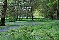
Bluebells in St Leonard's Forest in 2009
|
|
| Geography | |
| Location | West Sussex, England |
| Elevation | 40 metres (130 ft) to 145 metres (476 ft) |
| Area | 12 sq mi (31 km2) |
| Administration | |
| Governing body | Multiple - Forestry Commission, Horsham District Council, Private |
| Ecology | |
| Disturbance | Rhododendron |
| Lesser flora | Bilberry |
| Fauna | Blue butterfly, stonechat |
St Leonard's Forest is a beautiful wooded area in West Sussex, England. It sits at the western end of the Wealden Forest Ridge, which stretches from Horsham to Tonbridge. This forest is part of the High Weald Area of Outstanding Natural Beauty, a special place protected for its natural beauty.
The forest is located south of the A264 road, between the towns of Horsham and Crawley. You'll find the villages of Colgate and Lower Beeding inside the forest. While much of the original forest has been cleared over time, a large part remains covered in trees.
Some areas of St Leonard's Forest are open for everyone to enjoy. The Forestry Commission manages about 289 hectares (714 acres) of public land. Other public spots include Owlbeech and Leechpool Woods near Horsham, and Buchan Country Park near Crawley. The rest of the forest is privately owned, with only a few public paths for walking or horse riding. Leonardslee Gardens, a famous local attraction, reopened in 2019 after being closed for several years. A special part of the forest, covering 85.4 hectares, is protected as the St Leonards Forest Site of Special Scientific Interest.
You can find car parks at Roosthole (for the Forestry Commission area), Owlbeech/Leechpool on Harwood Road, and Buchan Country Park on the A264. Two long-distance walking paths cross the forest: the High Weald Landscape Trail and the Sussex Ouse Valley Way.
St Leonard's Forest is one of four "stately Wood Nymphs" mentioned in an old poem from 1611. These forests were once part of a huge ancient woodland called Andreaswald, now known as the Weald. Long ago, these forests were used for hunting. By the 1500s, they became important for England's iron industry. Today, you can still see the "hammer ponds" that were used in iron production. These ponds are now popular for fishing.
Contents
- Forest Geology: What's Under Your Feet?
- A Look Back: The History of St Leonard's Forest
- Early Times and Ancient Paths
- The Legend of St. Leonard
- The Dragons of St. Leonard's Forest
- The Middle Ages: Hunting and Resources
- The 1500s: Iron and Clearing the Forest
- The 1600s: Timber and Heathland
- The 1700s: Rabbits and Barren Land
- The 1800s: New Plantings and Gardens
- The 1900s: Rhododendron and Public Access
- The 2000s: Forest Future
- Images for kids
Forest Geology: What's Under Your Feet?
St Leonard's Forest sits on a geological feature called an anticline, which is like a giant upward fold in the rock layers. The land here ranges from 40 meters (131 feet) high in Horsham to 144 meters (472 feet) in Pease Pottage.
Rivers and Water Flow
Streams flowing north from the forest are called brooks. Those east of Colgate eventually join to form the River Mole. Streams west of Colgate flow into Chennells Brook, which then joins with streams flowing south (called gills) to form the River Arun. The forest ridge east of Colgate acts as a watershed. This means it separates the water that flows north towards the River Thames from the water that flows south towards the English Channel. The southern edge of the forest drains into the River Adur, and the southeastern part drains into the River Ouse.
Rocks and Their History
The forest's geology mainly consists of layers of sandstones, siltstones, and clays. These rocks often have a lot of iron in them. They are part of the Tunbridge Wells Sand Formation, which is a section of the Hastings Beds. These rocks were formed a very long time ago, during the early Cretaceous period. They were laid down in a large floodplain, possibly by a river. The clay layers suggest that sometimes the sea level rose, turning the floodplain into a coastal lagoon.
You might notice muddy sections on paths and tracks, which show where the clay layers are. Some fields are on the sandstones. Historically, these rocks were important. For example, a strong sandstone called Tilgate Stone was often quarried for building materials. Another thin, layered rock called Horsham Stone was dug up southwest of Horsham and used for pavements and roofs. Some pieces of Horsham Stone even show ripple marks from ancient water.
The rocks in the western part of the forest contained enough iron to be mined. Both clays, silts, and sandstones were dug up for their iron content.
A Look Back: The History of St Leonard's Forest
Early Times and Ancient Paths
St Leonard's Forest was once part of the huge, dense Weald forest. This forest stretched across southern England. It was mostly too thick to travel through easily. However, on the poorer, sandy parts of the forest ridge, the trees were thinner. This allowed Mesolithic people (from the Middle Stone Age) to create a trackway along the top. They left behind burial mounds and worked flints along this ancient route.
Later, the forest was slowly opened up by different groups of people. The South Saxons moved north from the coast, and the Middle Saxons moved south from the North Downs.
The Legend of St. Leonard
The forest's name is thought to come from Saint Leonard. He was a Frankish nobleman who lived a religious life in the 5th and 6th centuries. Legend says that after helping King Clovis I, St. Leonard was given as much land as he could ride around on a donkey in a day. He then started a monastery at Noblac in France. In his later years, he became a forest hermit.
Noblac became a place where people would go on pilgrimages. Many crusaders, including King Richard the Lionheart, visited it. This might be how the story of St. Leonard came to England, where many churches are named after him. However, a local story says that St. Leonard's own hermitage was actually in this very forest, though this is probably just a legend.
The "tithes" (a type of tax, often a tenth of farm produce) for the forest were given to Sele Priory. The Benedictine monks there built a hermitage dedicated to St. Leonard in the forest, but its exact location is now unknown.
The Dragons of St. Leonard's Forest
There's a famous local legend about St. Leonard being a Dragon Slayer. The story says he lived in the forest and killed the last dragon in England! An old chronicle from 770 AD even mentions "Monstrous serpents were seen in the country of the Southern Angles that is called Sussex."
The legend says St. Leonard was hurt during his fight with the dragon. Where his blood fell, beautiful Lilies of the Valley grew. There's even an area of the forest still called The Lily Beds. As a reward, St. Leonard supposedly asked for snakes to be banished from the forest and for the nightingales to be silenced because they interrupted his prayers.
Even in August 1614, a pamphlet was published describing a "strange and monstrous Serpent (or Dragon)" found in St. Leonard's Forest. It claimed the dragon was causing "great Annoyance and divers Slaughters both of Men and Cattell."
Today, the only "dragons" you'll find are a pub in Colgate and a bronze dragon statue in Horsham Park.
The Middle Ages: Hunting and Resources
In 1086, the Sauvage family owned Sedgwick Park on the west side of the forest. Later, the Braoses of Bramber Castle took over. In 1258, they were allowed to build battlements on Sedgwick Castle. During this time, the forest was mainly used for pannage, which meant letting pigs feed on acorns and nuts. The lords of Bramber and Bewbush held these rights.
The forest also had wild horses, which might be where the name Horsham came from. A horse fair was even held on St. Leonard's Day in the 15th century. Deer and timber belonged to the lord. Timber from the forest was sent to Dover in 1214 to build a new great hall. Oak trees were given to the Bishop of Chichester in 1234 for the cathedral.
Sele Priory had the rights to the "underwood" (smaller trees and shrubs) in 1234. This wood was used to make charcoal. This is why the village of Colgate got its name, as a charcoal burner was known as a "collier." By 1295, the forest was home to deer, hares, rabbits, pheasants, and herons.
Later, the forest was surrounded by a "pale" or fence. This made it a "chase" (a private hunting ground) rather than a true forest under strict forest law. There were gates into the forest, and some of their names are still used today, like Faygate in the north, Monk's Gate in the southwest, and Pease Pottage Gate in the east. Other gates divided areas within the forest, like Colgate. Some place names, like Doomsday Green and Mannings Heath, refer to clearings in the woods.
The 1500s: Iron and Clearing the Forest
By the 1500s, St. Leonard's Forest was divided into different areas called "bailiwicks." Many of these names, like Roffey and Shelley, are still known today. Around this time, people started clearing parts of the forest. The wood was used for barrels, buildings, and especially for charcoal. Charcoal was needed for both iron production and for the people of Horsham. By 1553, it was reported that there were no deer or other game left in the forest. By the end of the century, about 40 farms were in the forest, though the poor soil made farming difficult.
It's not clear when ironworking began in the forest, but it was well-established by the mid-1500s. The Romans had worked iron nearby at Crawley, so it's possible there were earlier workings. The most visible remains today are Hawkins Pond and Hammer Pond. These ponds were created by dams, which Hammerpond Road now crosses.
There was a blast furnace at Bewbush that made pig iron. This pig iron was then turned into wrought iron at finery forges below the two ponds. Water was essential to power a waterwheel, which in turn lifted the heavy "trip hammers" used in the process. Around 1584, another blast furnace was built at Hammer Pond to process iron ore from near Colgate. This furnace used up to 1,000 loads of ore each year.
Another furnace was built at Crabtree around 1580, getting its ore from Minepits Wood. In 1587, 49 miners worked there. Furnaces at Slaugham also got their ore from the forest. The main iron products were cannon and firebacks. Iron production in the area stopped around 1650 when the iron works were destroyed during the English Civil War.
The iron industry wasn't the only reason for the loss of trees. While some large timbers were used for buildings, the main need was for charcoal. This was made from smaller trees and by a method called coppicing, where trees are cut back to the stump to regrow.
The 1600s: Timber and Heathland
In 1602, The Crown (the King or Queen) owned the rights to the forest's timber. During the first half of the 17th century, much of the large timber was used for shipbuilding. Other timber was used for charcoal. By the middle of the century, large areas, especially Bewbush and Shelley Plain, had been cleared. Cattle, sheep, and rabbits grazed there, preventing new trees from growing. These areas became farmland. Other parts of the forest turned into heathland.
The 1700s: Rabbits and Barren Land
Rabbits became the main product of the forest in the 18th century. The first rabbit farms, called warrens, were mentioned in 1614. By the early 1700s, there were five warrens, including the Great Warren south of Colgate. By the end of the century, one warren had about twelve thousand rabbits, with London being the main market.
The forest was described as "bleak and barren" like moorland. In 1823, a traveler named William Cobbett called the six miles through the forest "the worst miles in England." He said it was a "bare heath here and there, in the better parts of it, some scrubby birch."
However, around 1720, Michael Mills planted a straight avenue of trees. Although these trees were blown down in a storm in 1836, the line of the avenue remains as a long, narrow clearing. A local legend says that Mick Mills raced the devil and won, going so fast that he burned the trees on either side, and they would never regrow.
The 1800s: New Plantings and Gardens
In the 19th century, much of the heathland was turned into pasture for animals. Many new trees were also planted, mainly larch, fir, oak, sweet chestnut, and spruce. These plantings happened mostly on large estates like Holmbush and Buchan Hill.
Exotic gardens, featuring plants like magnolias and rhododendrons, were created in the second half of the century. Leonardslee and South Lodge became two well-known examples. New dams were built to create lakes for decoration at Leonardslee and for fishing and boating at Buchan Hill. A tall tower, 106 feet high, was built at Holmbush. This is why the road there is called Tower Road, replacing its old name, Beacon Hill, which suggests it was once used as a lookout, perhaps during the Napoleonic Wars.
The 1900s: Rhododendron and Public Access
A big change in the 20th century was the spread of rhododendron throughout the forest. This plant grew everywhere except where the Forestry Commission had planted dense trees. The amount of heathland decreased, unless it was purposely kept, like in Buchan Country Park.
In the second half of the century, Buchan Country Park, Owlbeech, and Leechpool Woods opened to the public. These areas, along with the Forestry Commission land, allow people to access parts of the forest. Building has increased throughout the forest, even though it is now an Area of Outstanding Natural Beauty.
Two large golf courses were built at Mannings Heath and Buchan Hill. The first one at Mannings Heath opened in 1905.
The 2000s: Forest Future
Today, there is an effort to reduce the amount of rhododendron in the forest. Unfortunately, the more it's cut back, the more it regrows. The value of the trees managed by the Forestry Commission has dropped, making it less profitable to cut them down. Over the next thirty years, the plan is to increase the amount of native woodland in the forest.
Images for kids
-
Bluebells in St Leonard's Forest in 2009
