
River Ouse, Sussex facts for kids
Quick facts for kids Ouse |
|
|---|---|

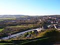
View looking north towards Cliffe at high tide from Southease swing bridge
|
|
| Country | England |
| Counties | West Sussex, East Sussex |
| Towns/Cities | Slaugham, Lindfield, Newick, Isfield, Barcombe, Lewes, Newhaven |
| Physical characteristics | |
| Main source | Lower Beeding, West Sussex, UK 85 m (279 ft) 51°02′20″N 0°14′04″W / 51.038875°N 0.234315°W |
| River mouth | English Channel Newhaven, East Sussex, UK 0 m (0 ft) 50°47′03″N 0°03′29″E / 50.784217°N 0.057995°E |
| Length | 35 miles / 56km |
The River Ouse (pronounced OOZ) is a 35-mile (56 km) long river in the English counties of West Sussex and East Sussex. It starts near Lower Beeding in West Sussex. The river then flows east and south, finally reaching the sea at Newhaven. It flows past towns like Haywards Heath and through Lewes.
The Ouse is the main river in a large network of smaller streams. The River Uck is its most important tributary. Near the coast, the river flows through the Lewes and Laughton Levels. This is a flat, low-lying area next to the river and another tributary, the Glynde Reach. Long ago, around 1086, this area was a large tidal inlet. Over many centuries, people tried to turn some of the valley into farmland. They built walls to hold back the water. However, a big shingle bar, made of small stones, formed at the river's mouth. This bar made it hard for the water to drain away.
In 1539, a new channel was dug through the shingle bar. This helped the land become green meadows for a while. But floods returned, and the meadows turned back into marshland. Engineers later suggested ways to improve the drainage. In 1790, a group was formed to make the river easier for boats to use. They built 19 locks, which are like water elevators for boats. This allowed boats to travel far up the river to Balcombe. By 1829, even large 120-ton ships could reach Lewes. However, trains became more popular, and by 1868, boats stopped using the upper river.
The lower part of the river continued to be important. Newhaven became a busy port. Barges carried goods up to Lewes until the 1950s. Today, ferries still sail from Newhaven to France. The river is home to many kinds of fish, including large sea trout. The Lewes Brooks area is special because of its many different insects. You can walk along the river on the Sussex Ouse Valley Way footpath. Some groups are working to bring boat travel back to the upper river.
Contents
Where Does the River Ouse Flow?
The River Ouse and its main helper, the River Uck, drain a huge area of Sussex. This area is over 250 square miles (650 km²). There are about 750 miles (1,200 km) of streams in total. About 140 miles (225 km) of these are "main rivers." The Environment Agency looks after these main rivers.
The river starts near Lower Beeding in West Sussex. It winds its way east. It passes under Upper Ryelands Bridge, which was once as far as boats could go. After a tributary from Ardingly Reservoir joins it, the river turns southeast. It flows north of Lindfield and Haywards Heath. It enters East Sussex near Sheffield Park railway station. This station is part of the old Bluebell Railway. After going around Newick, it turns south. The River Uck, its main tributary, joins it from the northeast near Isfield. Most of the streams that join the Ouse here come from the forests of the High Weald. These streams are fast-flowing and cut deep valleys.
Below Isfield, the narrow valley opens into a wide flood plain. Other streams like the Longford Stream and Bevern Stream join the Ouse. Then it reaches Barcombe Mills. At Barcombe, there are many channels. These once provided water for watermills. The last mill burned down in 1938. On the east side of the river is Barcombe Reservoir. This is where South East Water takes water from the river. They clean it and send it to homes. Just north of this, on the west bank, is the Anchor Inn. This old inn, built in 1790, offers boat rentals and food.
Some streams in this middle section are like those higher up. Others are slower-moving lowland streams. The Bevern Stream starts in the South Downs chalk hills. Below Barcombe, the river is partly tidal. It forms large bends, with many ox-bow lakes. At Hamsey, a straight channel cuts across a big bend. This creates Hamsey Island, where St Peter's Church stands. This old church dates back to the 12th century. A half-weir here helped stop a pesticide spill in 2001. That spill killed many insects and fish further upstream.
The tidal river flows through the town of Lewes. The river channel here has changed a lot over time. Three bridges cross it. Willey's Bridge is a small footbridge built in 1965. It helps people get to South Malling church and Lewes. The Phoenix Causeway is a larger road bridge built in 1979. It helps traffic go around Cliffe High Street. The Grade II listed Cliffe Bridge carries the High Street. It was built in 1726-27 and is made of red brick. After Cliffe, the Winterbourne stream flows into the Ouse. It also supplies water to the Railway Land nature reserve. This 25-acre (10 ha) reserve was once railway sidings. It has a reed bed called the Heart of Reeds. The Ouse continues southeast past Glynde. Here, the Glynde Reach tributary joins from the east. Then it passes Rodmell, Southease, and Piddinghoe. There are public paths along both sides of the river here.
At Southease, there is a swing bridge built in 1880. It has three arches, with two that used to swing open. It was operated by hand. This type of bridge is rare. In 1988, it was decided to fix the bridge in place. It had not opened since 1967. The river finally reaches Newhaven. Here, it separates industrial Denton Island from the main land. A wooden drawbridge was built in 1794. It carried the coastal road over the river. In 1866, a cast iron swing bridge replaced it. This bridge carried both a road and a tramway. The tramway was used to build the West Quay breakwater, finished in 1889. A new road bridge, higher up, replaced the swing bridge in 1974. It opens regularly for ships. This can cause traffic jams on the A259 road. Below the bridge, the river becomes the Port of Newhaven. There is a ferry terminal here for trips to Dieppe in France. This ferry service has been running since 1847. Finally, the river flows into the English Channel. It is surrounded by two long breakwater piers.
What Does "Ouse" Mean?
"Ouse" is a common name for rivers in England. There's the Ouse in Yorkshire. There's also the Great Ouse and Little Ouse further east. The name might come from an old Celtic word, "Ūsa." This word means "water." It's related to the Indo-European word "*udso-", which also means "water." If this is true, then "River Ouse" would mean "Water River" or "Wet River."
However, some people think the name is different. The National Rivers Authority said the river above Lewes was once called "Middewinde." The part from Lewes to the sea was called "The Great River of Lewes." They believe the current name "Ouse" is a shorter version of "Lewes," and it rhymes with it.
How the Ouse Valley Was Formed
The Ouse is one of four rivers that cut through the South Downs hills. Scientists believe its valley was formed during an ice age. It's what's left of a much bigger river system. This ancient river once flowed onto the floor of what is now the English Channel. During warmer times between ice ages, the lower valley would have flooded. There are old beaches 40 meters and 8 meters above today's sea level. This shows how much the sea level has changed. The coastline today is similar to what it was before the last ice age. This means the mouth of the Ouse has been in its current spot for a very long time.
Flooding and Drainage History
When the Domesday Book was written in 1086, the Ouse valley was probably a tidal inlet. Settlements were built along its edges. Later, the river drained the valley well enough for some marshland to become valuable meadows. But by the 1300s, the Ouse valley often flooded in winter. The water sometimes stayed on the meadows all summer. In 1422, a group was set up to fix the river banks and drainage. This shows how bad the flooding was. By the 1530s, over 6,000 acres (2,400 ha) of the Lewes and Laughton Levels were marshland again.
A big problem was a huge shingle bar at the river's mouth. This bar was created by longshore drift, which moves sand and pebbles along the coast. The bar had moved east to Seaford. This was about 2 miles (3.2 km) from where it was in Roman times. The bar stopped the river from draining properly. It also made it hard for ships to enter. In 1537, money was collected to dig a new channel through the shingle bar. This new channel was below Castle Hill at Meeching. It helped the river drain the Levels. This new channel also created a safe harbor, Newhaven. Newhaven then became the main port instead of Seaford.
The new channel was finished by 1539. It drained the Levels so well that much of the valley became pasture land. But shingle kept building up, and the river mouth started moving east again. By 1648, the Ouse was not good for drainage or for boats. The Newhaven Harbour Commissioners were set up in 1731. They tried to improve the river entrance. An engineer named John Reynolds built a sluice at Piddinghoe. This was meant to hold back water to clean the channel. But it broke in 1736. By the 1700s, the valley was often flooded in winter and sometimes in summer.
Smeaton's Ideas for Drainage
In 1767, a famous engineer named John Smeaton studied the river. He looked at the drainage of the levels. He found that many meadows were underwater. He saw that the river level was higher than the meadows at high tide. He also noticed that the tide rose and fell a lot at Newhaven. But it barely moved at Lewes Bridge. This was because of sandbanks and the narrow, winding river. He also saw the big shingle bar at Newhaven. If it was removed, water levels would be much lower at low tide.
Smeaton suggested straightening the river and removing all blockages. He also wanted to build a sluice to stop tides from entering the river. This sluice would also act as a lock for boats. He thought this would cost about £10,800. The Commissioners did some of his suggestions in 1768. They dredged the river below Lewes. But they didn't straighten the river much, and Smeaton's big sluice was never built.
Boats on the Ouse River
There is some proof that boats used the Ouse in the early 1700s. Maps from 1724 show boats going to Maresfield Forge. There was also a lock, which was probably a simple "flash lock." Smeaton's plan for a lock at Piddinghoe wasn't built. The river remained free to use. In 1790, a law was passed. It said the river was only used from the sea to Barcombe Mills at that time.
In 1788, another engineer, William Jessop, looked at the river. He thought it could be made suitable for boats up to Pilstye Bridge. This would need the river to be 4 feet (1.2 m) deep and 24 feet (7.3 m) wide. Boats 45 by 12 feet (13.7 by 3.7 m) could carry 30 tons. This would involve straightening curves and building 25 locks. He thought it would cost £14,400. He also suggested making the river wider and deeper between Lewes and Newhaven. This would cost an extra £1,980.
A law was passed on April 28, 1790. It allowed improvements to the river between Lewes Bridge and Hammer Bridge. A company called "The Company of Proprietors of the River Ouse Navigation" was created. They could raise £25,000. Work on the river couldn't start until they had £10,000. Another law was passed in 1791. This one covered the river between Lewes and Newhaven. It aimed to improve both boat travel and drainage.
Work began in May 1790. By April 1793, boats could travel from Lewes to Sheffield Bridge. The costs reached £20,000. But the money from tolls was very small. From 1797, the navigation was in trouble. But by 1805, they had enough money to open another 1.5 miles (2.4 km) to Freshfield Bridge. Tolls increased. In 1806, they got another law passed. This allowed them to raise £30,000 more. They hired a geologist named William Smith as an engineer. By the end of 1809, the river was open to Lindfield Mill.
The navigation reached its longest point in 1812. It was 22.5 miles (36.2 km) long. It went to Upper Ryelands Bridge at Balcombe. There was also a 0.75-mile (1.2 km) branch to Shortbridge. There were 19 locks. Each lock was 52.5 by 13.5 feet (16.0 by 4.1 m). Barges could carry 18 tons. This was less than Jessop had planned. It seems the river wasn't as deep as he wanted. The tolls were enough to pay back borrowed money, but not to pay shareholders.
Improving the Lower River
Many attempts were made to improve the tidal river below Lewes. In 1730, engineer John Reynolds looked at the pier at Newhaven. A law was passed in 1731. The Harbour Commissioners hired him to fix the piers. This cost £3,000. Over the next four years, piers were fixed and made longer. But Reynolds' sluice at Piddinghoe, built in 1731-1733, failed. It was removed in 1736.
The 1791 law to straighten the channel below Lewes was managed by Trustees. Money came from river tolls and a drainage charge for landowners. Work on straightening the lower river happened between 1791 and 1795. A schoolmaster and engineer named Cater Rand oversaw Jessop's plans. A bridge at Southease was needed because the river's new path divided farmland. The costs for landowners were too high. So, another law was passed in 1800. This law changed the tolls to make things fairer.
From 1783, John Ellman, famous for his farming, helped manage the Lewes and Laughton Levels. He worked hard to organize and watch over work on the Glynde Reach and the lower Ouse. Because of his efforts, a 120-ton ship could unload stone at Lewes Bridge by the late 1820s. He retired in 1828. The next year, the river flooded. But the improvements helped the meadows drain in just 48 hours. A shallow part near Lewes Bridge was finally removed in 1838. Work on the west breakwater at Newhaven began in 1866. This huge structure protects the river mouth. It allows ships to enter Newhaven port at all tides. It was finished in 1889. A tramway was used to build and maintain it. The tracks were removed in 1963. The locomotive used on the tramway, No. 72 Fenchurch, is now preserved on the Bluebell Railway.
How the River Was Used
Trade on the Ouse Navigation mainly involved lime, chalk, fertilizer, stones, and coal. In 1801, 51 barges were registered. 21 of them worked above Lewes. But the navigation was never a huge business success. In 1825, there was an idea for a canal from Lewes to Brighton. But nothing happened with it.
Trains arrived in the early 1840s. The London and Brighton Railway was built. At first, this helped the river trade. 11 million bricks from the Netherlands were brought along the Ouse. They were used to build the Ouse Valley Viaduct. Some goods were carried up the river and then put on trains. But this didn't last long. The coastal railway from Brighton to Lewes opened in 1846. Money from tolls dropped a lot. By 1859, the company stopped keeping records. The river above Lindfield was not used after 1861. The last barge to Lindfield sailed in 1868. After that, no trade happened above Lewes. But boats continued to use the Lower Ouse below Lewes.
A big user of the lower river was the Southerham Cement Works. It was on the east bank of the river near Lewes railway bridge. This place had a chalk pit since at least 1725. It became a cement works in the 1800s. The works had its own barges. They brought coal, coke, and clay to the site. They carried lime and cement away. Even though it had a railway connection, barges continued to serve the works until the 1950s.
Managing the River Today
Today, the Environment Agency manages the River Ouse. They work to prevent floods. There have been big floods in 1960, 1979, 1987, 1993, and 2000. These floods affected towns like Lewes and Haywards Heath. The river has banks below Barcombe Mills. These protect farmland and about 2,000 homes. After the 1960 floods, the channel below Lewes was made wider. Its banks were raised. Water is also pumped into the river from drainage ditches. Since 1973, tidal water cannot enter the Laughton Level. This is because a dam and pumping station were built. There are several pumping stations along the river. They pump water into the river from the land.
The work to improve the river has not stopped all flooding. On the upper river, you can still see the remains of old locks. They are slowly falling apart. The Sussex Ouse Conservation Society helps people learn about the river's history. They publish details of walks along the river. The Sussex Ouse Valley Way is a long footpath. It starts near the river's source and is 42 miles (68 km) long. It ends at the sea near Seaford. The Sussex Ouse Restoration Trust wants to bring boat travel back to the upper river. They have fixed Isfield Lock. However, the Ouse and Adur Rivers Trust thinks this would harm the river's environment.
Mills Along the Ouse
The river has been used for power for many years. Nine mills were on the main river channel. There were also mills on smaller streams. A tide mill was at Bishopstone. The northernmost mill on the main channel was Fletching Mill. It was a forge in 1574. Later, it became a mill for grinding corn. It stopped using water power in the 1920s. It was used until 1940, when soldiers used it. The building was damaged and torn down in 1950.
Between 1813 and 1816, a papermaker built a paper mill near Sharp's Bridge Lock. Paper making stopped there by 1853. The mill was torn down by 1874. Isfield Paper Mill was built next to Isfield Lock. It opened in 1809. But it was offered for sale in 1855. The building materials were sold in 1857.
At Barcombe, there were two mills. Barcombe Oil Mill crushed seeds to make oil. It also ground corn. It was powered by a waterwheel. Later, a steam engine was added. Oil was used for soap and paint. Oil cake was used for animal feed and fertilizer. Much of the mill burned down in 1854. But it was rebuilt and continued working. It was torn down around 1917.
Barcombe Mill was much older. It was used for fulling cloth, then for corn and paper. It grew when the river navigation helped transport goods. A new, larger mill was built in 1870. It had four floors and used two water wheels. It could produce 500 to 600 sacks of flour each week. Milling stopped in 1918. The building was destroyed by fire in 1939. Little remains today.
Further downstream, Germany Mill was built in 1744. When the river's path changed, the mill lost its water. The building still exists, but it's now used for drying grain. Lewes Paper Mill operated from 1802 to 1825. A large flour mill was built on the site in 1860. But it closed in 1868.
The last mill was Bishopstone Tide Mill. It was east of the river's mouth. It was built in 1788. It was a large mill with three floors. It could produce 1,500 sacks of flour each week. It was often damaged by storms. It continued to operate until 1883, when a big storm hit. The area around the mill, known as Tide Mills, was a small community. About 60 men worked there. The owner built cottages and a school for his workers' children. Almost nothing remains of this large mill today.
River Ouse Wildlife
The River Ouse is home to many types of fish found in Britain. It's famous for the very large sea trout that swim up the river each year to lay their eggs. There are also pike and carp, which can weigh over 30 pounds (14 kg). Other fish include barbel, roach, dace, rudd, perch, chub, bream, and tench. Some rare fish like grayling, stone loach, river lampreys, and bullhead also live here. The parts of the river with some salt water have fish that can handle it. These include flounder, grey mullet, bass, twait shad, and sea lampreys.
Lewes Brooks is a special nature area west of the river. It's known for its many different water beetles, rare snails, flies, and moths. The area is good for wildlife because the water changes from fresh in the west to slightly salty in the east. Scientists have studied how chemicals from sewage treatment plants affect fish in the river.
River Water Quality
The Environment Agency checks the water quality of rivers in England. Each river gets an overall "ecological status." This can be high, good, moderate, poor, or bad. This status looks at the number and types of invertebrates, plants, and fish. They also check the "chemical status," which looks at chemical levels. Chemical status is either good or fail.
Most of the River Ouse is called "heavily modified." This is because of all the work done to straighten it for boats. In 2016, the water quality of the River Ouse system was mostly "moderate" for ecological status and "good" for chemical status.
| Section | Ecological Status | Chemical Status | Overall Status | Length | Catchment |
|---|---|---|---|---|---|
| Ouse from Slaugham to Ardingly Reservoir | Poor | Good | Poor | 6.9 miles (11.1 km) | 14.49 square miles (37.5 km2) |
| Ouse Ardingly to confluence with Scrase Brk | Moderate | Good | Moderate | 4.5 miles (7.2 km) | 4.66 square miles (12.1 km2) |
| Middle Ouse | Moderate | Good | Moderate | 9.2 miles (14.8 km) | 10.55 square miles (27.3 km2) |
| Ouse between Isfield and Coast | Moderate | Good | Moderate | 2.4 miles (3.9 km) | 0.99 square miles (2.6 km2) |
| Ouse | Moderate | Good | Moderate |
Fun Facts About the Ouse
The famous author Virginia Woolf drowned herself in the River Ouse on March 28, 1941, near the village of Rodmell. Her body was found on April 18.
The Ouse Summer Raft Race is held every year. Teams build their own rafts and paddle down the river. The race goes from Lewes to Newhaven. At Lewes and Southease, crowds on the bridges and riverbanks throw eggs, flour, seaweed, and water at the rafters!
Images for kids
-
This straightened part of the River Ouse near Lewes is called Cliffe Cut. It was made in the late 1790s.
-
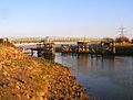
Southease swing bridge was built in 1880. It no longer opens.
-
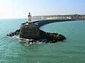
The west breakwater stops shingle from blocking the river mouth at Newhaven.


See also
 In Spanish: Río Ouse (Sussex) para niños
