Glynde Reach facts for kids
Quick facts for kids Glynde Reach |
|
|---|---|

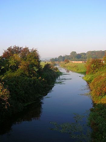
Glynde Reach near Glynde
|
|
| Country | England |
| County | East Sussex |
| Villages | Beddingham, Glynde, Ringmer, Laughton, Ripe, Selmeston |
| Physical characteristics | |
| Main source | Selmeston, East Sussex, UK 50°50′37″N 0°08′25″E / 50.843594°N 0.140326°E |
| River mouth | River Ouse UK 50°50′52″N 0°02′18″E / 50.847698°N 0.038201°E |
| Length | 7.75 mi (12.47 km) |
Glynde Reach is a river in East Sussex, England. It is a smaller river that flows into the River Ouse. The main water for Glynde Reach comes from areas near Laughton, Rushy Green (which is close to Ringmer), and streams near Selmeston and Ripe.
Contents
History of Glynde Reach
The River in Olden Times
Around the year 1086, when the Domesday Book was made, Glynde Reach and the River Ouse were likely a tidal inlet. This means sea water would flow in and out with the tides. At that time, a big industry in the area was making salt by drying out sea water. Records show there were salt works near Ripe and Laughton.
In the early 1300s, people started to build walls, called embankments, to create meadows on the flat land next to the river. But conditions got worse later in the century. Meadows at Beddingham were flooded during the summer for five years in the 1360s and three years in the 1380s.
Why the Flooding Got Worse
The condition of the land was linked to the River Ouse. When people built embankments, less water flowed out to the sea. This caused a large bank of pebbles and sand to form at the mouth of the Ouse, and the river's exit moved east towards Seaford. Because of this, the flat lands, known as the Lewes and Laughton Levels, became more flooded.
For example, about 400 acres of meadow land owned by the Archbishop of Canterbury near where Glynde Reach meets the Ouse became a permanent fishing area in the 1400s. It was called the Brodewater.
Solving the Flood Problems
In 1537, the people in charge of the Levels (called Commissioners) worked with Dutch engineers. They collected money from landowners whose land was at risk of flooding. By 1539, they had dug a new channel for the River Ouse through the pebble bank at Newhaven. This improved the drainage, and the Archbishop of Canterbury's Brodewater turned back into a meadow. It was still used as a meadow in 1616.
However, conditions got worse again in the late 1600s because the Ouse's outlet to the sea was getting blocked again. So, the Commissioners hired a famous engineer named John Smeaton to study the problem.
John Smeaton's Ideas
John Smeaton visited the area in June 1767. He looked at the meadows, which were called brooks. He saw that the brooks near Ranscombe, where Glynde Reach joins the Ouse, had low and poorly kept embankments. At high tide, the river water was higher than the meadows.
The brooks along Glynde Reach itself were generally higher, but they had standing water on them. Smeaton thought this was because the river had no slope and was very winding. He believed that if the problems at Ranscombe were fixed, the Glynde Reach problems would also get better.
He suggested making the River Ouse straighter and raising the embankments at Ranscombe. He also proposed building a huge gate (sluice) on the Ouse at Piddinghoe to stop tides from entering the river system. By 1768, the Commissioners had widened the Ouse below Lewes and cleaned out some of the worst muddy areas. But they didn't straighten the river much, and Smeaton's big sluice was never built.
 | Tommie Smith |
 | Simone Manuel |
 | Shani Davis |
 | Simone Biles |
 | Alice Coachman |

