River Little Ouse facts for kids
Quick facts for kids River Little Ouse |
|
|---|---|

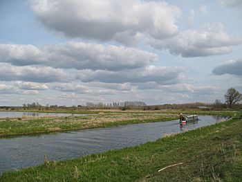
The river north of Lakenheath
|
|

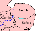
Little Ouse (light blue) and Great Ouse (dark)
|
|
| Country | England |
| Counties | Norfolk, Suffolk |
| Physical characteristics | |
| Main source | Thelnetham, Norfolk/Suffolk border 25 m (82 ft) 52°22′16″N 0°59′39″E / 52.37124°N 0.99405°E |
| River mouth | River Great Ouse Brandon Creek, Littleport, Cambridgeshire 0 m (0 ft) 52°30′04″N 0°22′01″E / 52.50121°N 0.36704°E |
| Length | 37 mi (60 km) |
| Basin features | |
| Tributaries |
|
The River Little Ouse is a river in eastern England. It is a smaller river that flows into the much larger River Great Ouse. For most of its journey, the Little Ouse forms the natural border between the counties of Norfolk and Suffolk.
This river starts near Thelnetham, very close to where the River Waveney begins. Interestingly, the Waveney flows east, while the Little Ouse flows west! The village of Blo' Norton got its name from this river. It used to be called Norton Bell-'eau, meaning "beautiful stream" in old French. Along its path, the river creates important wetland areas. These include places like Blo' Norton and Thelnetham Fens and areas looked after by the Little Ouse Headwaters Project.
The river flows through several towns and villages. These include Rushford, Thetford, Brandon, and Hockwold. Finally, it joins the Great Ouse near Littleport in Cambridgeshire. The Little Ouse is about 37 miles (60 km) long. You can even travel by boat on parts of it, from the Great Ouse up to about 2 miles (3.2 km) past Brandon.
Contents
Where Does the Little Ouse Begin?
The Little Ouse and the Waveney rivers start very close to each other. They both begin in a wide valley that cuts through clay and sand. The two rivers rise only about 160 yards (150 m) apart. This spot is at a height of about 85 feet (26 m).
Scientists have studied this unusual valley. They believe it was formed by water flowing from a huge glacial lake long ago. When the ice melted, it left behind the valley we see today. The sandy lake bed became the sandy area known as the Breckland. This is a large area of gorse-covered heath that stretches across Norfolk and Suffolk.
Over many years, the lower part of the Little Ouse has changed a lot. In the 1600s, engineers like Cornelius Vermuyden dug new channels. They connected the Great Ouse to the Little Ouse at Brandon Creek. This helped drain the land and made it easier for boats to travel towards King's Lynn.
The River's Journey
The Little Ouse starts near the B1113 road between South Lopham and Redgrave. It flows west and is joined by a stream from Rickinghall and Botesdale. Then it goes through Hinderclay Fen. This area was once a rich wetland, but it dried out because of changes made to the river for farming. Now, the Little Ouse Headwaters Project is working to bring the wetland back. They are making parts of the fen wet again and reintroducing rare plants and animals.
The river then turns northwest. It passes under the B1111 road near Garboldisham. You can see two old windmills nearby: Thelnetham windmill and Garboldisham windmill. Both are very old and important historical buildings. The river continues west, passing the ruined All Saints church at Gasthorpe. It also flows along the edge of Knettishall Heath Country Park. Here, two small weirs (small dams) are found. The Peddars Way and Norfolk Coast Path cross the river on a footbridge.
The river flows under a minor road at Rushford, where the bridge is a protected ancient monument. Another bridge carries the A1088 road into Thetford. The Black Bourn river joins the Little Ouse from the south. The combined rivers then flow north into Thetford. The border between Norfolk and Suffolk follows the river for most of its journey, but it goes around Thetford.
Through Thetford
As the river reaches Thetford, it flows through the Nunnery Lakes Reserve. This is a nature reserve managed by the British Trust for Ornithology (BTO). Deep pools were created here in the 1970s when sand and gravel were dug out. Now, it's a great place for wildlife. The BTO has its main offices nearby.
There are three old bridges on Nuns Bridge Road, which is part of the ancient Icknield Way. This path is thought to have been used as far back as 3000 BCE. The southernmost bridge, over the Little Ouse, was built in the late 1700s. It has two curved arches. For many years, there was an outdoor swimming pool in the river here. But it closed in the 1950s because of concerns about pollution.
Beyond Thetford
After the old pool site, the River Thet joins the Little Ouse. Here, you can see many channels, sluices, and weirs. There are also the remains of an old water mill from the early 1800s. The river then flows under Town Bridge, which is a single cast iron arch built in 1829. After passing under the A11 Thetford Bypass, the river runs alongside Thetford Forest. This is the largest man-made forest in Britain, covering about 72.3 square miles (187 km2).
A footpath called the St Edmund Way follows the river from Thetford. At Santon Downham, the Little Ouse Path continues along the north bank. This path used to be the towpath, where horses pulled boats along the river.
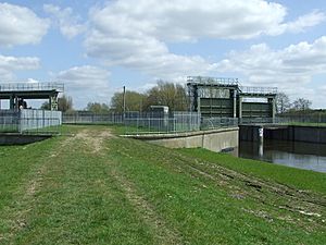
The river then passes Brandon Lock. This lock helps boats move between different water levels. The Breckland line railway crosses the river here. There's also an old Roman-British settlement nearby. The river has been moved from its original path to cross the Cut-off Channel using a concrete bridge. Large gates called guillotine sluices control whether the water goes into the lower river or into the Cut-off Channel.
South of the river, there are many wetlands and wooded areas. Some of this land used to be farms. But the Royal Society for the Protection of Birds (RSPB) turned it into the Lakenheath Fen wetland. This area is now home to many birds like reed warblers, marsh harriers, and bitterns. Near the mouth of the river, you can find the lowest trig point in Britain. It marks a spot that is 3 feet (0.91 m) below sea level! The Little Ouse joins the Great Ouse right after it goes under the A10 road.
Protecting the River from Floods
The Environment Agency has marked the section of the river from Thetford to Brandon as a Flood Warning Area. This means people are warned if there's a risk of flooding.
The lower part of the river crosses over the Cut-off Channel using a concrete bridge. The Cut-off Channel is a 28-mile (45 km) drain built in the 1950s and 1960s. During floods, it carries water from other rivers like the River Lark and the River Wissey to Denver Sluice. There are two sluices on the Little Ouse that can send floodwater into the Cut-off Channel. This helps protect the areas downstream. The flood banks in this lower section are very far apart, sometimes up to half a mile (0.8 km). This allows the river to spread out and form a large lake during floods.
Near the mouth of the river, there was once a pumping station called the Brandon Engine. It helped drain the northern part of Burnt Fen from 1830 until 1958. This engine was replaced several times, with more powerful pumps. In the 1950s, a new electric pumping station was built elsewhere. This meant the old Brandon Engine was no longer needed.
Boating on the Little Ouse
You can currently travel by boat on the Little Ouse for about 16.6 miles (26.7 km). This goes from where it joins the River Great Ouse up to Santon Downham bridge. People have been using the river for boats since the 1200s! Barges used to carry goods all the way to Thetford, which is about 6 miles (9.7 km) past Santon Downham. Stone used to build Thetford Priory in the 1100s was likely moved along this river.
However, when Denver Sluice was built on the Great Ouse, the water levels in the Little Ouse dropped. In the late 1600s, people tried to improve the river for boats. They built special gates called staunches. These held back water to make parts of the river deeper for boats. But they were not always effective.
In the 1750s, more improvements were made. New staunches were built at places like Thetford, Brandon, and Santon. These staunches were like simple locks. They would hold back water, then open to let boats pass. By the 1830s, these improvements were working well. The money collected from tolls (fees for using the river) was a big part of Thetford Corporation's income.
In the 1770s, there was a big plan to build a canal from Thetford to Bishops Stortford. This would have connected much of East Anglia to London by canal. But it was too expensive. The idea was finally dropped in the 1850s when railways arrived.
The railways caused the river's use for transport to decline quickly. Even though a paddle steamer offered trips in the 1880s, commercial traffic mostly stopped by the start of the First World War. Later, the old staunches were removed. New sluices were built at Thetford and Brandon.
Today, the river is mostly on one level for boats. There is one lock at Brandon, which opened in 1995. This lock is 13 feet (4.0 m) wide and 39 feet (12 m) long. This means it's not suitable for all types of boats. However, boats up to 79 feet (24 m) long can turn around just below the lock.
There is a group working to reopen the river for boats all the way to Thetford. Experts have studied this idea and think four new locks would be needed. In 2008, it became easier for boaters to reach Santon Downham. New places to moor boats were built there. Beyond Santon Downham bridge, the river is only suitable for canoes and small dinghies because of rocks.
River Water Quality
The Environment Agency checks the water quality of rivers in England. They give each river system an overall "ecological status." This status can be high, good, moderate, poor, or bad. They look at things like the types of invertebrates (bugs), plants, and fish living in the river. They also check for chemicals.
In 2016, the water quality of the River Little Ouse system was mostly "moderate." One small section near Thelnetham was rated "bad." The Environment Agency aims to improve this section to at least "poor" by 2021.
| Point | Coordinates (Links to map resources) |
OS Grid Ref | Notes |
|---|---|---|---|
| Jn with River Great Ouse | 52°30′04″N 0°22′00″E / 52.5011°N 0.3668°E | TL607918 | |
| Lakenheath Lode | 52°26′33″N 0°27′19″E / 52.4426°N 0.4554°E | TL669855 | |
| Cut-off Channel sluices | 52°27′13″N 0°32′49″E / 52.4537°N 0.5469°E | TL731870 | |
| Brandon Lock | 52°26′57″N 0°36′57″E / 52.4493°N 0.6157°E | TL778867 | |
| Santon Downham | 52°27′31″N 0°40′24″E / 52.4586°N 0.6732°E | TL817878 | Limit of navigation |
| Abbey Heath Weir | 52°25′34″N 0°43′15″E / 52.4260°N 0.7209°E | TL850843 | |
| Jn with River Thet | 52°24′48″N 0°44′48″E / 52.4133°N 0.7468°E | TL869830 | |
| Jn with The Black Bourn | 52°23′11″N 0°46′24″E / 52.3863°N 0.7732°E | TL888800 | |
| Source of river | 52°22′16″N 0°59′39″E / 52.3712°N 0.9942°E | TM039790 |
 | Laphonza Butler |
 | Daisy Bates |
 | Elizabeth Piper Ensley |


