
Cut-off Channel facts for kids
Quick facts for kids Cut-off Channel |
|
|---|---|

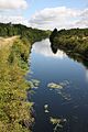
The Cut-off Channel near Feltwell
|
|
| Country | England |
| Counties | Norfolk, Suffolk |
| Physical characteristics | |
| Main source | Mildenhall, Suffolk |
| River mouth | Denver Sluice Denver, Norfolk |
| Length | 28 mi (45 km) |
The Cut-off Channel is a special waterway built by people. It runs along the eastern edge of the Fens in Norfolk and Suffolk, England. This channel is about 28 mi (45 km) long. It was built in the 1950s and 1960s to help prevent floods.
When there's a lot of rain, the channel carries extra water from rivers like the River Wissey, River Lark, and River Little Ouse. It sends this water to Denver Sluice on the River Great Ouse. This stops the Fens from flooding. In the summer, the channel also helps supply drinking water to people in Essex. Water flows backwards from Denver to a special intake at Blackdyke. From there, it travels through tunnels and pipes to reservoirs in Essex.
Contents
The Cut-off Channel: A Lifeline for the Fens
Why Was It Built?
People have wanted to drain the Fens for a very long time. This was to turn marshy land into useful farmland. As early as 1639, a Dutch engineer named Cornelius Vermuyden suggested building a "cut-off drain." This drain would collect water from several rivers and send it to the River Great Ouse at Denver. However, this idea was not put into action, probably because it was too expensive.
Later, in 1810, another engineer named John Rennie also suggested a similar channel. Again, the cost was too high, so it wasn't built.
Flooding Problems
The Fens continued to suffer from serious floods. In 1937 and 1939, big floods caused a lot of damage. Even worse, in 1947, huge floods covered about 58 square miles (150 km2) of land in the South Level area. Many families had to leave their homes. Army engineers and volunteers worked hard for weeks to fix the damaged river banks and pump the water away.
These terrible floods made it clear that something big needed to be done. The Great Ouse Catchment Board decided to bring back the idea of a cut-off channel. An engineer named Sir Murdoch MacDonald designed a plan very similar to Vermuyden's original idea.
How It Was Built
Construction of the Cut-off Channel finally began in 1954. It was part of a larger project to protect communities near the Great Ouse from flooding. The channel was finished by 1964. It helps control about 40 percent of the water that flows into the Great Ouse.
Water for Essex
Around the same time, planners in Essex needed more drinking water for their growing towns. By 1968, a plan was made to use the Cut-off Channel for water supply. During summer, water from the Great Ouse is sent into the channel at Denver. It then flows south to Blackdyke Intake.
From Blackdyke, the water goes down a 90 feet (27 m) shaft into a tunnel. It is then pumped 280 feet (85 m) back up to the surface at Kennett Pumping Station. Pipelines carry the water to a brook, which flows into the River Stour. Finally, the water is taken from the river and pumped to Abberton Reservoir and Hanningfield Reservoir in Essex. This whole system is called the Ely-Ouse to Essex Water Transfer Scheme. It was completed in 1971.
Home to Wildlife
The Cut-off Channel passes through different types of soil. This creates many different places for plants and animals to live. For example, in some areas, the riverbed is sandy with pebbles. Here, you might find lots of green algae and Canadian pond weed. In other places, the bed is covered in fine chalky silts, where fewer plants grow.
Surveys in 1997 and 1998 found that the channel is home to a small number of depressed river mussels. These mussels were first found near Methwold. Near the Blackdyke Intake, where water is taken for Essex, the channel is dredged (cleaned) every year to prevent plants from clogging the intake. Even here, mussels have been found.

Helping Fish Move
The Cut-off Channel is important for flood control, but it also needs to be good for wildlife. Fish could enter the channel from Denver Sluice but then get trapped. They couldn't easily reach other rivers or good places to live.
To solve this, a special fish pass was built in 2013. It connects the channel to the River Wissey. There is a height difference of about 8.2 feet (2.5 m) between the two waterways. The solution was a "syphon fish pass," which uses a clever design to move fish safely. It also includes a way for eels to pass through. This project cost £407,000 and helps fish like gudgeon, perch, pike, and roach move freely. Experts are still watching the fish pass to make sure it works well for all types of fish, including trout and silver eels.
Water Quality
The Environment Agency checks the water quality of rivers in England. They give each river an overall "ecological status." This status can be high, good, moderate, poor, or bad. They look at things like the types of invertebrates (small creatures without backbones), plants, and fish living in the water. They also check the chemical status, comparing chemical levels to safe limits. Chemical status is either "good" or "fail."
In 2016, the Cut-off Channel's water quality was rated as follows:
| Section | Ecological Status | Chemical Status | Overall Status | Length | Catchment |
|---|---|---|---|---|---|
| Cut-off Channel | Moderate | Good | Moderate | 28.1 miles (45.2 km) | 58.55 square miles (151.6 km2) |
It's good news that the chemical status improved to "good" since 2014, when it was rated "Fail."
Images for kids
-
The Cut-off Channel near Feltwell
