
River Waveney facts for kids
Quick facts for kids Waveney |
|
|---|---|

The River at Beccles
|
|
.png)
Course of the Waveney.
|
|
| Country | England |
| Counties | Norfolk, Suffolk |
| Physical characteristics | |
| Main source | nr. Redgrave, Suffolk 25 m (82 ft) 52°22′16″N 0°59′41″E / 52.3712°N 0.9946°E |
| River mouth | Breydon Water Great Yarmouth, Norfolk, UK 0 m (0 ft) 52°34′59″N 1°38′49″E / 52.583°N 1.647°E |
| Length | 58.75 mi (94.55 km) |
| Basin features | |
| Basin size | 339 sq mi (880 km2) |
| Tributaries |
|
The River Waveney is a river that marks the border between Suffolk and Norfolk in England. It flows for most of its length through The Broads, a beautiful area of rivers and lakes. The word "Waveney" actually means "river river" because "ey" means river.
Contents
Journey of the River Waveney
The River Waveney starts as a small ditch. This ditch is found between the villages of Redgrave, Suffolk and South Lopham, Norfolk. Interestingly, a ditch on the other side of the road is the start of the River Little Ouse. This means that during heavy rain, Norfolk can almost become an island! This unusual start happened because a huge ancient lake, called Lake Fenland, once spilled its water here. This lake existed thousands of years ago during the last Ice Age.
From Source to Diss
The river begins at about 25 meters (82 feet) above sea level. It flows east through towns like Diss, Bungay, and Beccles. Near its source, it forms the southern edge of Bressingham and Roydon. Then it reaches the town of Diss.
Waveney's Path to Bungay
At Scole, an old Roman road crosses the river. A modern road, the A140 bypass, is just east of it. You can find a small waterfall, called a weir, at Billingford. The Billingford Windmill stands a little north of the river. Further on, the River Dove joins the Waveney from the south. The river then drops below 20 meters (66 feet) at another weir.
It turns northeast towards Brockdish and Needham. It then passes south of Harleston. On the south bank, there are several large lakes. These lakes were once gravel pits but are now popular for fishing.
Historic Bridges and Nature Spots
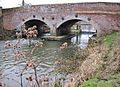
Below these lakes, you can see the remains of an old priory and the wide, drained area of Mendham Marshes. Mendham is on the Suffolk side. Homersfield is also in Suffolk. In 1869, the Homersfield Bridge was built here. It was one of the first bridges made from concrete and iron. This bridge is now the oldest concrete bridge in England and is a very important historic structure. It was restored in 1995.
On the Norfolk side, opposite Homersfield, are the villages of Alburgh, Denton, and Earsham. Near Flixton, The Saints is the Norfolk and Suffolk Aviation Museum. At Earsham, the Otter Trust used to have a center. It helped increase the number of otters in the river.
Reaching the Broads and the Sea
At Bungay, the Waveney makes a wide loop, called an oxbow meander. The border between Norfolk and Suffolk follows this loop. Inside the loop is the Bungay and Waveney Valley golf course. Next, on the Norfolk side, are Ditchingham, Broome, and Ellingham.
At Geldeston, there's a pub next to where a lock used to be. This lock is now a sluice. This is as far as larger boats can travel up the river. From this point, the Waveney becomes a tidal river, meaning its water level changes with the sea tides. On the Suffolk side are Mettingham, Shipmeadow, and Barsham.
The river then reaches Beccles, where it enters the Broads. The old town bridge at Beccles is quite low, so only boats shorter than 2 meters (6 feet 6 inches) can pass. Beccles was once a fishing port. The parents of Lord Nelson were married in a church here.
The river then winds past nature reserves and Burgh St Peter to Somerleyton. Here, Oulton Dyke branches off to Oulton Broad and then towards Lowestoft. A sea lock, called Mutford Lock, separates the fresh river water from the salty seawater. This lock connects Oulton Broad to Lake Lothing and the North Sea.
At Somerleyton, a railway line crosses the Waveney on a swing bridge. At St Olaves, the Haddiscoe Cut branches off. This cut was dug in the 1800s to connect the Waveney and Yare rivers. It created a direct route between Lowestoft and Norwich. Finally, the Waveney flows past Burgh Castle into Breydon Water. It then joins the River Yare and reaches the sea at Great Yarmouth.
People have used the River Waveney for travel and trade for a long time. In 1670, an Act of Parliament allowed improvements to the river. This included building three locks at Geldeston, Ellingham, and Wainford. These locks helped boats travel further upstream to Bungay.
The river navigation was privately owned for many years. In 1772, another Act made sure that local judges received a share of the tolls (money paid to use the river). This money was used to maintain the Waveney. Over the years, different merchants owned the navigation rights. One famous owner was the firm that first owned the wherry boat called Albion. This boat is now looked after by the Norfolk Wherry Trust.
Connecting to the Sea
In the early 1800s, there was a big plan to connect Norwich to the sea at Lowestoft. This plan led to the creation of the Norwich and Lowestoft Navigation Company in 1827. They planned to widen Oulton Dyke and build a new sea lock to link Oulton Broad to Lake Lothing. This new lock was very large and could hold big ships. It also had a system to flush the channel with water from Oulton Broad to keep it clear.
Work also began on the Haddiscoe Cut. This cut connected the Waveney at Haddiscoe to the River Yare at Reedham. This allowed boats from Norwich to avoid going through Yarmouth. The whole project officially opened in 1833. However, it wasn't a big success because Norwich didn't become a major port, and Lowestoft harbour often got blocked with sand. The company struggled financially and was eventually taken over and sold.
Before World War II, commercial use of wherries (special boats) declined. This meant some parts of the Broads, including a section of the Waveney from Geldeston Lock to Bungay, were no longer used for navigation.
Today, local volunteers from the River Waveney Trust are working to restore Geldeston Lock. The other locks, Wainford and Ellingham, have become sluices. However, the Environment Agency has worked with landowners to allow canoes and other unpowered boats to use this part of the river. They have also improved places where people can carry their boats around the sluices.
Mutford Lock is the only working lock in all of the Broads. It connects Oulton Broad to Lake Lothing. This lock was updated in 1992. It is now managed by Sentinel Enterprises Limited, which also runs the Oulton Broad Yacht Station.
Mills Along the Waveney
The River Waveney is quite flat, but it has still powered at least 15 mills over the centuries. Some of these mills have been around for over 900 years! Most of them ground corn to make flour or animal feed. Today, all the remaining mills are privately owned.
Early Mills and Their Uses
The first mill upstream was Scole Flax Mill. It was powered by steam, not water. It was built in 1854 to help people find work. Farmers were encouraged to grow flax, a plant used to make linen, sacks, and rope. Oil was also made from its seeds. The mill closed in 1881.
The first watermill was at Hoxne. The current building was built in 1846. Mills have been on this site since at least 1086. These mills were used for grinding corn, making textiles, and processing flax. The mill stopped being used in 1968, but its wheel and some machinery are still there.
Syleham Mill is mentioned as early as 1020. The last mill building there was built after 1779. It used to have six grinding stones. Later, it was used to weave a coarse cloth called drabbet. The mill and part of the factory burned down in 1928, but the factory was rebuilt and made men's clothes until 1989.
More Mills and Their Stories
Needham Mill was once owned by a monastery. It appears on maps from 1736. Even though it's called Needham Mill, it's actually on the Suffolk side of the river in Weybread. It stopped milling in 1934 and was turned into a house in 1971. The weir and sluice were rebuilt in 1963 to help measure water flow and prevent flooding.
Weybread mill is also mentioned in the Domesday survey. In 1794, details from its sale showed it had two large wheels and five grinding stones. It was a five-story building. It burned down two years later and was not rebuilt.
Mendham had a mill in 1086. The current building was built in 1807. It was later updated with a steam engine and then diesel engines to help power the mill when water levels were low. The mill stopped working in 1949.
Limbourne Mill in Wortwell is also mentioned in the Domesday Book. It was owned by a Benedictine Nunnery. It was still in use in 1933 but was unused by 1949. Some of its original machinery still exists. Homersfield Mill also dates back to 1086. The mill and its cottage were taken down in 1927 after the river bank collapsed.
River Waveney Water Quality
The Environment Agency checks the water quality of rivers in England. They give each river system an overall "ecological status." This status can be high, good, moderate, poor, or bad. They look at things like the types of bugs, plants, and fish in the water. They also check the chemical status, comparing chemical levels to safe limits. Chemical status is either "good" or "fail."
In 2019, the water quality of the River Waveney system was mostly "moderate" for ecological status. The chemical status was "fail" for all sections. This means the overall status was "moderate."
The main reasons for the water quality not being "good" include:
- Sewage discharge affecting most of the river.
- Changes made to the river channels by people.
- Poor management of farms and rural land near the river.
Where to Find the Waveney
| Point | Coordinates (Links to map resources) |
OS Grid Ref | Notes |
|---|---|---|---|
| Source | 52°22′16″N 0°59′38″E / 52.371°N 0.994°E | TM039789 | |
| Homersfield | 52°25′16″N 1°21′25″E / 52.421°N 1.357°E | TM283856 | Concrete bridge |
| Bungay | 52°27′22″N 1°26′42″E / 52.456°N 1.445°E | TM341898 | Old head of navigation |
| Geldeston | 52°27′58″N 1°31′19″E / 52.466°N 1.522°E | TM393911 | Current head of navigation |
| Beccles | 52°27′54″N 1°33′40″E / 52.465°N 1.561°E | TM420912 | |
| Jn with Oulton Dyke | 52°29′24″N 1°40′55″E / 52.490°N 1.682°E | TM500943 | to Lowestoft harbour |
| Jn with Haddiscoe Cut | 52°31′55″N 1°37′12″E / 52.532°N 1.620°E | TM456989 | to River Yare |
| Jn with Breydon Water | 52°34′59″N 1°38′49″E / 52.583°N 1.647°E | TG471046 | Mouth |
Images for kids
-
First crossing, at source, Redgrave & S. Lopham Fen
-
Second crossing, as channel forms, Redgrave Fen
-
Denmark Bridge, Diss
-
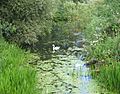
Pair of swans near walking path under A140 bridge
-
View of Waveney near Roman road: Scole Bridge towards A143
-
Billingford Bridge & weir, January 2011
-
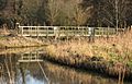
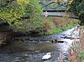
Hoxne weir footbridge
-
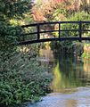
Homersfield Bridge: oldest concrete bridge in Great Britain
-
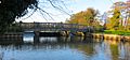
Bungay: Earsham St bridge, (beyond private footbridge)
-
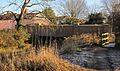
Staithe weir gates and footbridge, Bungay
-
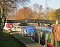
Beccles: upstream view of Bridge St bridge, showing height limit
-
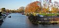
Beccles quay: downstream view from Bridge St bridge


See also
 In Spanish: Río Waveney para niños
