
Haddiscoe Cut facts for kids
Quick facts for kids Haddiscoe Cut |
|
|---|---|

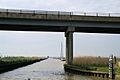
The bridge carrying the A143 over the Cut
|
|
| Specifications | |
| Maximum boat length | 46 ft 0 in (14.02 m) |
| Maximum boat beam | 18 ft 0 in (5.49 m) |
| Locks | 0 |
| Maximum height above sea level | 0 ft (0 m) (tidal - 3ft rise) |
| Status | Navigable |
| Navigation authority | The Broads Authority |
| History | |
| Original owner | Norwich and Lowestoft Navigation Co |
| Principal engineer | William Cubitt |
| Date of act | 1827 |
| Date of first use | 1833 |
| Geography | |
| Start point | Reedham, River Yare |
| End point | Haddiscoe, River Waveney |
The Haddiscoe Cut, also known as the New Cut, is a special waterway called a canal. You can find it in Norfolk, a county in England. It's also part of The Broads National Park, a beautiful area with many rivers and lakes.
This canal was built to create a shorter path for boats traveling between Lowestoft and Norwich. It was part of a bigger plan to connect the River Waveney to Oulton Broad and Lake Lothing. The Haddiscoe Cut officially opened in 1833. However, it didn't make much money. Because of this, it was sold to a railway company in 1842.
The canal stayed under railway ownership until 1948. In 1953, it was damaged by big floods. There was a plan to close it in 1954, but local people wanted it to stay open. So, it was repaired instead. Today, the Environment Agency helps manage and look after the Haddiscoe Cut.
Contents
Why Was the Haddiscoe Cut Built?
Before the 1820s, boats bringing goods to Norwich used the River Yare. This river flows into a wide, shallow area called Breydon Water. After that, it joins the River Bure and then the North Sea near Great Yarmouth.
Because Breydon Water was so shallow, large cargo boats couldn't reach Norwich directly. Goods had to be moved from big ships to smaller boats at Yarmouth. This process was called "trans-shipment." Merchants in Norwich were unhappy about the extra costs. They also worried about their cargo being stolen. In 1820, 18 men were even found guilty of stealing goods.
Because of these problems, a smart engineer named William Cubitt was asked to find a better solution in 1814.
Early Plans for Better Waterways
William Cubitt's first idea was to make the River Yare better. He suggested making a deeper channel along the southern edge of Breydon Water. He thought this would cost about £35,000. His plan was shared in 1818.
However, the town of Yarmouth quickly disagreed. They asked another engineer, John Rennie, for his opinion. Rennie believed Cubitt's plan would cause Yarmouth harbour to fill with mud.
So, Cubitt looked for other options. He came up with a plan to connect the River Yare to Lowestoft. This new idea would cost over £70,000. Yarmouth still objected, but a new law based on this plan was proposed in Parliament in 1826. It didn't pass that year. However, a second version of the law was passed on May 28, 1827. Yarmouth tried hard to stop it, but they were not successful.
Building the New Waterway
The new law created a company called the Norwich and Lowestoft Navigation Company. This company was allowed to raise £100,000. They could also get an extra £50,000 if needed.
The big project included several parts:
- Making the River Yare deeper from Norwich to Reedham.
- Building the Haddiscoe Cut, which is about 2.5 miles (4 km) long. This cut connects Reedham to Haddiscoe on the River Waveney.
- Making Oulton Dyke wider. This dyke connects the Waveney to Oulton Broad.
- Creating a channel between Oulton Broad and Lake Lothing. This channel was about 0.25 miles (0.4 km) long. It also had a special "sea lock" so boats could use it no matter the tide.
Work started on the Lake Lothing link first. Most of it was finished in 1829. The lock was very large, about 150 feet (46 m) long and 50 feet (15 m) wide. It had a clever system of gates called sluices. These sluices used water from Oulton Broad to help clear a path to the sea through Lake Lothing. On June 3, 1831, they showed how it worked. It was estimated that 3,000 tons of stones and gravel were washed out to sea!
The agreement to build the Haddiscoe Cut was signed with Thomas Townsend in July 1832. Work began right away. The company didn't have enough money at first. So, they borrowed the extra £50,000 from a special loan group. The cut was finished in 1832, and the River Yare was made deeper by 1833. The entire waterway, which is about 32 miles (51 km) long, officially opened on September 30, 1833.
How the Canal Was Used
The new waterway did not make enough money. The company couldn't pay back the £50,000 loan. So, in 1842, the loan group took control of the canal. They sold it to Sir Samuel Morton Peto. He was a developer who wanted to build railways.
A railway line from Reedham to Lowestoft was built right next to the Haddiscoe Cut. It actually forms the southwestern bank of the canal. Even though the canal was still used by boats, it was owned by different railway companies for the next 100 years.
After the railways became owned by the government, control of the Cut went to the British Transport Commission. In 1953, big floods damaged the canal. The Transport Commission tried to close it in 1954. But local people, especially those who enjoyed yachting, strongly disagreed. So, the canal was saved. In 1957, control passed to the East Suffolk and Norfolk River Board. Later, the Anglian Water Authority and then the Environment Agency took over its management.
The Haddiscoe Cut Today
In 1993, some of the railway embankment next to the canal collapsed. More recently, new flood protection work has been done. This included rebuilding the river defenses and walls. This important work was finished in 2006.
The Haddiscoe Cut is still an important part of the Broads today. It allows boats to travel between the River Yare and the River Waveney.
Images for kids
-
The bridge carrying the A143 over the Cut
