Weald facts for kids
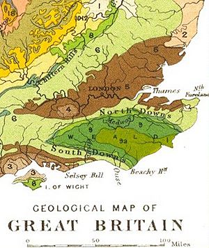
The Weald is a special area in South East England. It sits between two lines of chalk hills called the North Downs and the South Downs. This area stretches across parts of Hampshire, Surrey, Sussex, and Kent.
The Weald has three main parts:
- The "High Weald" in the middle, made of sandstone.
- The "Low Weald" around the edges, made of clay.
- The Greensand Ridge, which wraps around the north and west. This ridge has the highest points in the Weald.
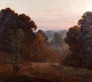
Long ago, the Weald was covered in thick forests. Its name comes from an Old English word meaning "woodland." Even today, many small farms and villages in the area still use "Weald" in their names.
Contents
What Does "Weald" Mean?
The name "Weald" comes from the Old English word weald, which means "forest." It's similar to the German word Wald.
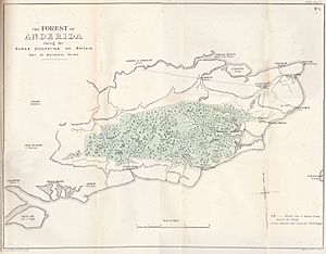
In the early Middle Ages, this area was called Andredes weald. This meant "the forest of Andred." "Andred" came from Anderida, the Roman name for a place now called Pevensey. Sometimes, it was also called Andredesleage, where leage was another Old English word for "woodland."
When we talk about things from the Weald, we use the word "wealden."
How the Weald Was Formed
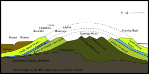
The Weald is what's left after a huge dome of rock, called an anticline, wore away. Imagine a giant bump in the Earth made of many layers of rock. Over millions of years, wind and rain wore down the top of this bump. This exposed the different rock layers below.
The oldest rocks you can see in the middle of the Weald are from the Upper Jurassic period. Above these are rocks from the Lower Cretaceous period. These include layers of sand and clay, like the Ashdown Sand and Weald Clay.
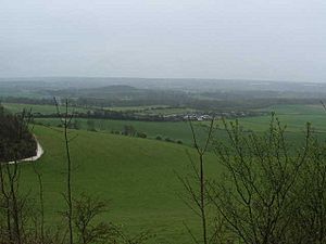
The hard sandstone rocks in the middle of the anticline form the hills of the High Weald. The areas around the edges have softer sandstones and clays. These form the gentler, rolling landscape of the Low Weald.
The Weald's rock structure actually continues under the Strait of Dover into France!
Amazing Fossil Discoveries
Many important fossils have been found in the Weald's sandstones and clays. For example, the Baryonyx dinosaur was found here.
In 1822, Mary Mantell found some strange fossil teeth by a road in Sussex. Her husband, the geologist Gideon Mantell, realized they looked like giant iguana teeth. This amazing discovery led to the identification of the first Iguanodon dinosaur. This find was a big step in understanding dinosaurs!
A Look at the Weald's Past
Long, long ago, after the Stone Age hunter-gatherers, people started farming in the Weald. This meant they began clearing parts of the forest.
During the Iron Age, the Weald became an important industrial area. The local sandstones contained ironstone, and there was plenty of wood to make charcoal for fuel. This made the Weald a center for making iron. This industry lasted from Roman times until 1813. Roman maps show many iron mines in the Weald.
The Great Forest
The entire Weald was once a huge, dense forest. In the 800s, the Anglo-Saxon Chronicle said the Weald was over 120 miles long and 30 miles wide. It stretched from Kent to Hampshire.
This forest was not very populated. People living on its edges used it for resources, like other wild areas in Britain. For centuries, people used the Weald to move their animals to summer grazing lands. Over time, much of the forest was cut down for shipbuilding, charcoal, glassmaking, and brickmaking. Today, only parts of the original woodland remain in the Low Weald.
Some parts of the forest on the higher ridges were used for hunting by the kings of Sussex. These areas include Ashdown Forest.
A Place of Refuge
The Weald's thick forests were often used as a safe hiding place. The Anglo-Saxon Chronicle tells a story from when the Anglo-Saxons conquered Sussex. The native Britons were pushed from the coast into the forest for safety:
A.D. 477. This year came Ælle to Britain, with his three sons... There they slew many of the Welsh; and some in flight they drove into the wood that is called Andred'sley.
Until the late Middle Ages, the forest was known as a hiding spot for bandits and highwaymen.
How Villages Grew
Villages in the Weald are spread out. They grew from small settlements in the woods, usually about 4 to 5 miles apart. This was close enough to walk easily but far enough to give people space. Many settlements were not even mentioned in the Domesday Book.
Before permanent settlements, the Weald was used as summer grazing land for animals. Many places in the Weald still have names from this time, ending in "-den." For example, Tenterden was the area used by people from the Isle of Thanet.
By the late 1500s, there were about 100 iron furnaces and forges working in the Weald. These employed many people.
Darwin and the Weald
Charles Darwin, famous for his theory of natural selection, used the Weald in his first book, On The Origin of Species. He tried to estimate how long it took for the Weald's rock layers to wear away. He thought it eroded about one inch per century. Based on this, he calculated the Weald was around 300 million years old. He believed this meant the Earth itself must be much older.
However, another scientist, William Thomson, later calculated that the Sun had been burning for less than a million years. This made Darwin's geological estimates seem too long. So, Darwin removed his calculations about the Weald from later editions of his book.
Today, we know that the Weald Clays were formed about 130 million years ago.
Where is the Weald?
The Weald starts in Hampshire and stretches across Surrey and Kent in the north, and Sussex in the south. It is about 85 miles long from west to east and 30 miles wide from north to south. It covers about 500 square miles.
Parts of the Weald are protected areas, like the South Downs National Park and the High Weald Area of Outstanding Natural Beauty.
High Weald
The High Weald is the central part. It is known for:
- Rolling hills with sandstone rocks sticking out.
- Steep-sided valleys called "gills" carved by streams.
- Small, uneven fields and patches of heathland.
- Lots of woodlands.
- Scattered farms and old, sunken roads.
Ashdown Forest is a large area of heathland and woodland in the High Weald. It was once a royal deer-hunting forest created by the Normans. It's thought to be the biggest remaining part of the ancient Andredesweald forest.
Some larger towns in the High Weald include Horsham, East Grinstead, Tonbridge, and Tunbridge Wells.
Low Weald
The Low Weald is the area around the edges of the High Weald. It looks very different. It has wide, low-lying clay valleys with small woodlands called "shaws" and fields. There are many ponds and winding streams.
Some flat areas, like around Crawley, have been developed for towns and Gatwick Airport. But most of the Low Weald still has its old village pattern. Villages and small towns are often found on harder rock outcrops. There are no very large towns in the Low Weald itself.
Rivers and Streams
Many streams flow out from the Weald. Most of them feed into larger rivers like the Mole, Medway, and Rother. These streams were important in the past. They powered watermills, iron furnaces, and cloth mills.
Getting Around the Weald
Major highways like the M25 and M20 motorway run along the northern edge of the Weald. The M23/A23 road crosses the Weald from north to south. Other roads, like the A21 to Hastings, have many hills and bends.
Building railways across the Weald was difficult because of the hard sandstone and hilly land. Engineers had to build long tunnels and viaducts.
The Weald also has many footpaths for walkers and cyclists.
Farming in the Weald
The soils in the Weald are not ideal for growing many crops. The High Weald has thin, poor sands, and the Low Weald has wet, sticky clays. This makes intensive farming difficult.
The Weald has its own type of cattle called the Sussex. These strong, red beef cattle were once used to pull ploughs in the heavy clay soils. Pigs were also common in the past, as they could be fattened on acorns from the oak woods in autumn.
Wildlife of the Weald
The Weald has kept much of its wooded character. About 23% of the area is still covered by woodland, which is one of the highest levels in England. In some central parts, the proportion is even higher.
The sandstone rocks in the Weald are often acidic. This creates acidic habitats like heathland. The largest remaining heathland areas are in Ashdown Forest.
Wild boar used to live in Great Britain but died out by the 1600s. However, wild boar populations have recently returned to the Weald. They escaped from boar farms and now live freely in the area.
Culture and Inspiration
The Weald has inspired many famous writers, especially in the 1800s and early 1900s. These include Vita Sackville-West, Arthur Conan Doyle, and Rudyard Kipling.
A. A. Milne's famous Winnie-the-Pooh stories were inspired by Ashdown Forest. Milne lived nearby in Hartfield.
In the early 2000s, the Tunbridge Wells Borough Council promoted "Seven Wonders of the Weald." These included:
- Bayham Old Abbey
- Bedgebury Pinetum
- Bewl Water
- Finchcocks
- Lamberhurst Vineyard
- Marle Place
- Scotney Castle
Sport in the Weald
The game of cricket may have started in the Weald before the 1200s. Another related game, stoolball, is still popular in the Weald, especially among ladies' teams.
Other "Wealds" and "Wolds"
There are other places in southern England named "Weald," like North Weald in Essex and Harrow Weald in north-west London.
The word "Wold" is used for open, rolling upland areas in northern England, like the Yorkshire Wolds. However, these "Wolds" are made of chalk hills, which is different from the Weald.
The Cotswolds are another major geographical feature in central England.
See also
 In Spanish: Weald para niños
 | Madam C. J. Walker |
 | Janet Emerson Bashen |
 | Annie Turnbo Malone |
 | Maggie L. Walker |


