High Weald Area of Outstanding Natural Beauty facts for kids
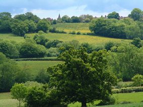
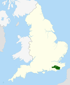
The High Weald Area of Outstanding Natural Beauty (AONB) is a special place in south-east England. It covers about 1,450 square kilometers (560 square miles). This beautiful area stretches across parts of East Sussex, Kent, West Sussex, and Surrey. It's the fourth largest AONB in England and Wales. Imagine a lovely landscape with small farms, lots of woods, old parks, hidden sunken lanes, and villages built on top of hills.
Contents
What is the High Weald AONB?
The High Weald became an AONB in October 1983. This happened under a special law called the National Park and Access to the Countryside Act 1949. Being an AONB means the area's unique landscape is officially recognized as important.
This special status helps government groups and local councils protect and improve the landscape. It also means they get financial help from Natural England, which is the main group for AONBs. Unlike National Parks, AONBs don't have their own separate management teams. Instead, they work with existing local councils. For the High Weald, this means coordinating with 15 different local authorities.
The Geology of the High Weald
The High Weald sits at the center of a special geological feature called the Weald anticline. Think of an anticline as a giant arch in the Earth's rock layers. Around the edges of the High Weald are flatter clay areas. These include the Low Weald, the Greensand Ridge, the North Downs, and South Downs.
In the middle of the High Weald, you'll find sandstones and clays. These rocks formed during the early Cretaceous period. They rise up to create the area's famous wooded ridges. Rivers like the Ouse, Medway, and Rother have cut deep, steep-sided valleys. These valleys are often wet and clayey. This geology, along with centuries of human activity, has shaped the landscape we see today.
A Unique Wooded Landscape
A long time ago, the entire Weald area was covered in thick forests. The Romans called it Silva Anderida. Over the last 1,500 years, much of this forest has been cleared. However, the High Weald still has many more woodlands than other parts of England.
In 1086, at the time of the Domesday Book, the High Weald was the most wooded natural area in England. Today, about 24.6% of the AONB is woodland. This is much higher than the national average of 9%. A big part of this, 17.6%, is ancient woodland. This means over half of the area's woods are very old. The High Weald AONB is only 1% of England's land, but it holds 3.4% of England's woodlands. This makes it one of the most wooded places in the country.
When you look at the High Weald from a distance, it seems very green and wooded. But up close, you'll see a mix of small fields, hedges, and woods. These are connected by sunken lanes, which were created by centuries of travel. This creates a beautiful pattern across the rolling hills and valleys.
Pioneer farmers in the late medieval period created the unique landscape of small fields and scattered farms. Early settlements were built on warmer, drier soils, on hilltops, and in river valleys. These valleys were also important travel routes. The wooded hills and the area's historical remoteness give the High Weald a feeling of being enclosed and peaceful. This is quite different from the more open areas around it and the busy, urban south-east England.
The highest sandstone hills in the High Weald are known as the Weald Forest Ridge. This ridge includes several ancient heathland forests. Some well-known ones are Ashdown Forest, St Leonard's Forest, Worth Forest, and Dallington Forest. Ancient woodland covers 22% of the Weald Forest Ridge. This is a very important amount of ancient woodland for the UK.
People and Villages
The High Weald AONB is mostly a rural area. It has an estimated population of about 124,880 people. This means there are about 0.85 people per hectare. The area is known for its scattered villages and spread-out settlements.
Two larger towns, Tunbridge Wells and Crowborough, are very close to the AONB but are not actually inside it. Battle and Cranbrook are the biggest settlements actually within the AONB. Each has over 6,000 residents. Many other major towns are close by, like Crawley, Horsham, and Hastings. These towns, along with Tunbridge Wells, Crowborough, and Battle, are home to almost 400,000 people. Many of these people visit and enjoy the natural spaces in the High Weald.
The Economy of the High Weald
In the past, farming in the High Weald was not very profitable. People mostly grew enough food for local needs. Woodlands were even measured by how many pigs they could support! There were also few large mills, roads, or canals. Because of this, and its remote location, the High Weald was one of the less wealthy parts of southern England.
However, things changed around 1490 with the fast growth of the iron industry. Crafts like weaving and tanning also grew. For a while, this made the High Weald one of England's wealthiest areas. By the 18th and 19th centuries, these industries moved to other places. Farming became the main activity again, but most farms were small and didn't make much money.
Today, farming, especially raising livestock, is still the main use of land in the AONB. But it accounts for less than half of the total area. Jobs in traditional industries like farming, forestry, and mining (for gypsum) have decreased a lot. Less than 10% of workers are in these jobs now. Only about 4,500 people work in agriculture out of the total population. However, farming is still important, along with tourism and leisure. Most businesses in the area are very small.
Over the centuries, wealthy people from outside the High Weald have moved there. This trend of rich city dwellers moving to the countryside started as early as the 14th century. Kent was a popular choice because it was easy to get to from London. This migration sped up in the 19th century when railways made travel from London much simpler. The money brought in by these wealthy newcomers helped create and maintain the many beautiful parks and gardens you see in the High Weald today.
Today, the High Weald still relies on people who live there but work outside the area. Many commute to places like Crawley, Gatwick, coastal towns, and London. About 70% of residents travel outside the area for work. Less than 7% earn their living directly from the land.
Fun Things to Do: Recreation
The High Weald AONB has many great places for recreation. Several long-distance walking paths cross the area. These include the High Weald Landscape Trail, Wealdway, 1066 Country Walk, Saxon Shore Way, Vanguard Way, and Sussex Border Path. There are over 2,000 kilometers (1,240 miles) of footpaths in total!
Bewl Water is one of five reservoirs in the AONB. It's the largest inland body of water in south-east England. It's also one of the most important places for tourists and recreation in the area.
Bedgebury Forest is a large area of ancient woodland and heath. It covers about 10.5 square kilometers (2,600 acres). Here, you can enjoy mountain biking, horse-riding, and other outdoor activities. The forest surrounds Bedgebury National Pinetum. This pinetum is said to have the most complete collection of conifer trees in the world. It's a major tourist attraction.
Ashdown Forest is a very important area of lowland heathland. It sits on the highest sandstone ridge of the High Weald. This forest was also the setting for the famous Winnie-the-Pooh stories by AA Milne. Ashdown Forest makes up two-thirds of the AONB's heathland. It has special protection as a UK Site of Special Scientific Interest. It's also a European Union Special Protection Area for birds and a Special Area of Conservation for its heathland. It's part of Natura 2000, which protects Europe's most important wildlife areas. The common lands in Ashdown Forest are open for everyone to enjoy.
 | Aurelia Browder |
 | Nannie Helen Burroughs |
 | Michelle Alexander |


