Royal Tunbridge Wells facts for kids
Quick facts for kids Royal Tunbridge Wells |
|
|---|---|
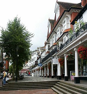 The Pantiles, the historic and tourist centre of the town |
|
 The coat of arms until 1972 |
|
| Population | 59,947 (2016) |
| OS grid reference | TQ585395 |
| • London | 33 mi (53 km) NNW |
| District |
|
| Shire county | |
| Region | |
| Country | England |
| Sovereign state | United Kingdom |
| Post town | TUNBRIDGE WELLS |
| Postcode district | TN1-TN4 |
| Dialling code | 01892 |
| Police | Kent |
| Fire | Kent |
| Ambulance | South East Coast |
| EU Parliament | South East England |
| UK Parliament |
|
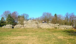
Royal Tunbridge Wells is a town in Kent, England. It is about 30 miles (48 km) southeast of central London. The town is near the border with East Sussex. It sits on the northern edge of the High Weald area. This area is known for its sandstone rocks, like the famous High Rocks.
The town became a popular spa in the 1600s. In the mid-1700s, under Beau Nash, it was a very fashionable place to visit. People came to The Pantiles to drink from its special chalybeate spring. They believed the water had healing powers. Even though sea bathing later became more popular, the town still earns a lot from tourism today.
Royal Tunbridge Wells has a population of about 56,500 people. It is the main administrative center for the Tunbridge Wells Borough. It is also part of the Tunbridge Wells parliamentary area.
Contents
- History of Tunbridge Wells
- How Tunbridge Wells is Governed
- Population and People
- Geography of Tunbridge Wells
- Economy and Jobs
- Getting Around Tunbridge Wells
- Education
- Sports and Activities
- Public Services
- Parks and Famous Places
- Arts and Culture
- Local Media
- Famous People from Tunbridge Wells
- See also
History of Tunbridge Wells
Early History: Iron Age to Roman Times
Evidence shows that people lived and worked in the Tunbridge Wells area a very long time ago. During the Iron Age, people farmed the land and mined iron from the rocks. In the 1940s and 1950s, digs at High Rocks found parts of an old defensive hill-fort.
It is thought that people continued to live here during Roman Britain. The area was part of the Wealden iron industry until the late 1700s. You can still see an old iron forge at Bayham Abbey. It was used until 1575.
How the Town Began
For many centuries, the area that is now Tunbridge Wells was part of the Speldhurst parish. The town we know today started in the 1600s. In 1606, a man named Dudley North, 3rd Baron North discovered a special spring. He was staying in Eridge to try and get better from an illness.
He drank from the spring and felt much better. He became convinced the water had healing powers. He told his wealthy friends in London about it. By 1630, when Queen Henrietta Maria, wife of King Charles I, visited, it was a well-known spa.
By 1636, it was so popular that two small buildings were put up next to the spring. One was for ladies and one for gentlemen. In 1664, Lord Muskerry built a stone wall around the spring. He also built a hall to shelter people drinking the waters in bad weather.
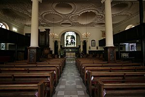
Until 1676, there were not many permanent buildings. Visitors had to camp or stay in Southborough. But then, houses and shops were built along the walks near the spring. In 1676, people started collecting money for a church. The Church of King Charles the Martyr was built in 1684. The town then grew around it.
In 1787, a writer named Edward Hasted described the new town. He said it had four small areas: Mount Ephraim, Mount Pleasant, Mount Sion, and the Wells.
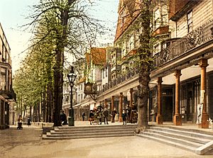
The 1680s saw a lot of building in the town. Shops were carefully planned along the 175-yard (160 m) Pantiles promenade. This area was then called the Walks. Mount Sion road was also laid out for lodging houses. Shopkeepers sold luxury items to their rich customers. This included "Tunbridge ware," which was a type of decorated wooden item.
A visitor in 1697, Celia Fiennes, wrote about the town. She said there were many good buildings for people to stay in. She also mentioned the market, which had lots of fish and fowl. The walk had shops selling toys, silver, china, and wooden goods. There were also coffee houses and rooms for gambling.
Later, in the mid-1700s, people started preferring sea bathing to spas. This meant fewer visitors came to Tunbridge Wells. However, new turnpike roads made travel easier. Public coaches ran between Tunbridge Wells and London many times a day.
The town continued to grow in the 1700s. Wealthy people still visited and even moved there. Famous people like Samuel Johnson and David Garrick came to the town. In 1735, Beau Nash became the master of ceremonies for all the town's entertainment. Under his guidance, Tunbridge Wells became very popular as a fashionable resort.
1800s and 1900s: Growth and Royal Status
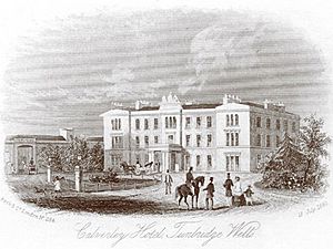
In the early 1800s, Tunbridge Wells grew as a place for wealthy people to live and visit. It became fashionable again after visits from Queen Victoria and Prince Albert. New areas like Mount Pleasant were developed, and Trinity Church was built in 1827.
Improvements like gas lighting and a police service helped the town grow. By 1837, the population reached 9,100. In 1842, an omnibus service started, connecting Tunbridge Wells to Tonbridge. This allowed visitors to arrive from London within two hours. In 1845, the town got a railway link to London.
In 1889, Tunbridge Wells became a Borough. It entered the 20th century in a good state. An Opera House opened in 1902. In 1909, the town received its "Royal" prefix.
During the First World War, Tunbridge Wells was an army headquarters. Its hospitals treated soldiers. The town also welcomed 150 Belgian refugees. The Second World War brought many refugees from London, straining accommodation. Over 3,800 buildings were damaged by bombs, but only 15 people died. After the war, new housing estates were built to handle the growing population.
What's in a Name?
The name "Tunbridge Wells" comes from its closeness to the town of Tonbridge. Tonbridge was known as "Tunbridge" until 1870.
The word "Royal" was added in 1909. King Edward VII gave the town this official title. It celebrated the town's popularity with the royal family over the years. Tunbridge Wells is one of only three towns in England with this "Royal" prefix.
Even though "Wells" sounds plural, it refers to the main spring at the Pantiles. This is where people used to drink the special waters.
How Tunbridge Wells is Governed
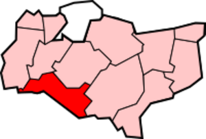
Tunbridge Wells is the main center for the Tunbridge Wells Borough. It is also the center for the Tunbridge Wells parliamentary area. The Borough is run by 48 Councillors. These councillors represent 20 different areas called wards. Eight of these wards are within the town of Tunbridge Wells itself.
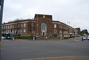
Elections for 16 council seats happen every year. Councillors serve for four years. They meet regularly at Tunbridge Wells Town Hall.
The local politics in Tunbridge Wells have changed over time. For many years, the Conservative party was very strong. However, in recent years, other parties have gained more influence.
The Member of Parliament (MP) for Tunbridge Wells is Mike Martin. He is a Liberal Democrat. The area has mostly elected Conservative MPs since 1974. However, in 2024, Mike Martin became the first Liberal Democrat MP for the area.
Population and People
| Ethnicity | Tunbridge Wells | South East | England |
|---|---|---|---|
| White | 97.5% | 95.1% | 90.9% |
| Asian | 0.6% | 2.3% | 4.6% |
| Black | 0.3% | 0.7% | 2.3% |
| Chinese / Other ethnic group | 0.7% | 0.8% | 0.9% |
| Mixed | 0.9% | 1.1% | 1.3% |
In 2006, the town of Tunbridge Wells had about 56,500 people. The wider Tunbridge Wells borough has more people, around 104,000 in 2001.
Most people in Tunbridge Wells are White and British. Most also identify as Christian. For example, in the 2001 census, 97.5% of residents said they were white. Also, 75.0% said they were Christian.
Geography of Tunbridge Wells
Tunbridge Wells is located on the border between Kent and East Sussex. It is about 31 miles (50 km) south of London. The very first part of the town sits right on the county line. You can still see a special flagstone outside the Church of King Charles the Martyr that marks this boundary.
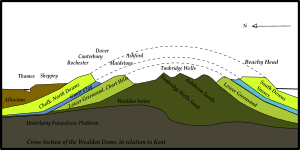
The town is on the northern edge of the High Weald. This is a ridge of hard sandstone that stretches across southern England. You can see this geology in the exposed sandstone rocks at Wellington Rocks and High Rocks. High Rocks is a special scientific site because of its unique rock formations. Sandstone from nearby Langton Green was used to build houses in Tunbridge Wells.
The town is at the top of a valley that goes southeast towards Groombridge. A stream in this valley is one of many small rivers that feed into the River Medway. The River Teise also starts in Tunbridge Wells. A geological unit called the Tunbridge Wells Sand Formation is named after the town.
Some nearby villages have grown and become part of the town. These include High Brooms to the north, Hawkenbury to the south, and Rusthall to the west. Rusthall's name hints at the iron content in the local rocks.
Twin Town
Tunbridge Wells is twinned with Wiesbaden, Germany. This friendship started in 1960 between former soldiers from both towns. It led to an official Twinning Charter being signed in 1989. The Tunbridge Wells Twinning and Friendship Association (TWTFA) helps keep this friendship strong.
Climate
Like the rest of Britain, Tunbridge Wells has a mild climate. This means it does not have extreme weather. The closest official weather station is in Goudhurst, about 8.5 miles (14 km) east of the town.
The highest temperature recorded in Goudhurst was 34.7°C (94.5°F) in August 1990. The lowest was -19.2°C (-2.6°F) in January 1940. On average, it rains about 823.3 mm (32.41 in) per year.
Economy and Jobs
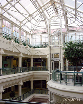
In 2002, about 50,000 people worked in the Tunbridge Wells borough. The biggest part of the local economy is hotels, restaurants, and shops. The Royal Victoria Place shopping centre, which opened in 1992, is a large part of this. It covers 29,414 square meters (316,610 sq ft). This accounts for about 30% of all jobs.
The finance and business sector makes up almost a quarter of jobs. The public administration, education, and health sectors also make up a similar amount. Tunbridge Wells is considered an important shopping area between London and Hastings.
One of the largest employers in the town used to be the Maidstone and Tunbridge Wells NHS Trust. They employed about 2,500 people at the Kent and Sussex and Tunbridge Wells Hospitals. The largest private employer was AXA PPP healthcare, with about 1,700 employees. Tunbridge Wells has a low unemployment rate, which means most people who want jobs can find them.
Getting Around Tunbridge Wells
Tunbridge Wells is a central point for several roads. The main roads include the A26, which goes from Maidstone to Newhaven. The A264 connects Five Oaks to Pembury. The A267 goes south from Tunbridge Wells to Hailsham. The A21 passes east of the town, connecting London to Hastings.
Bus services are mainly run by Arriva Kent & Sussex. They provide local services and routes to nearby towns like Tonbridge and Sevenoaks. You can also take buses to places like Bromley and Maidstone. Services to the south coast, like Eastbourne and Brighton, are also available.
Tunbridge Wells has two active National Rail train stations. Tunbridge Wells station is in the town center. High Brooms station is in High Brooms, north of the town. Both are on the Hastings Line. Trains are operated by Southeastern.
Tunbridge Wells West station opened in 1866 but closed in 1985. The old station building is now a restaurant. Part of the railway line was reopened in 1996 by the Tunbridge Wells and Eridge Railway Preservation Society. This is now the Spa Valley Railway, a heritage railway that runs steam trains from Tunbridge Wells West to Eridge.
Train travel between Tunbridge Wells and London has increased over the years. This shows how important the railway is for commuters.
Education
Kent County Council is one of the few local authorities in the UK that still uses the eleven plus exam. This exam helps decide which secondary school children will attend.
Tunbridge Wells does not have its own university. However, the Salomons Campus of Canterbury Christ Church University is just outside the town. It offers programs for students who have already completed their first degree.
Sports and Activities
Football
The town's football team is Tunbridge Wells F.C.. It was formed in 1886 and plays in the Southern Counties East Football League. The team reached the 2013 FA Vase final at Wembley Stadium.
Motorsport
Tunbridge Wells Motor Club is one of the oldest motor clubs in the UK, founded in 1911. It organizes various motorsport events in the area.
Rugby Union
Tunbridge Wells RFC is the town's rugby union team. They play their home games at St Mark's.
Rugby League
Weald Warriors RLFC is a rugby league team based in Tunbridge Wells. They were founded in 2012 and play in the 4th tier of English rugby league.
Cricket
The Nevill Ground hosts county and international cricket matches. Kent County Cricket Club often uses it. It is also the home of Tunbridge Wells Cricket Club. In the 1983 Cricket World Cup, Kapil Dev of India scored a world record 175 not out at this ground.
Linden Park Cricket Club plays its home matches at the Higher Common Ground on Tunbridge Wells Common.
Field Hockey
Tunbridge Wells Hockey Club is based at the Nevill Ground. It competes in the Men's England Hockey League and the South East Hockey League.
Swimming
The RTW Monson Swimming Club offers swimming, diving, and water polo. It is based at the Tunbridge Wells Sports Centre. A former member, Joanne Rout, won two gold medals and three silver medals at the 1988 Summer Paralympics when she was just 12 years old. She is the youngest-ever British Paralympian.
Running
The Tunbridge Wells Half Marathon is a road race held every February. It is organized by the Tunbridge Wells Harriers running club. There is also a weekly 5km Park Run in Dunorlan Park.
Squash
Tunbridge Wells Squash Club on London Road has three courts. It offers internal leagues for squash and racquetball. Squash facilities are also available at the Tunbridge Wells Sports Centre.
Curling
Fenton's Rink is near Tunbridge Wells. It is the only dedicated curling ice rink in England.
Public Services
Health services are provided by the West Kent Primary Care Trust. The new Tunbridge Wells Hospital at Pembury opened in 2011. It is about 3 miles (5 km) from the town.
Kent Police patrols Tunbridge Wells. The main police station for the area moved to Tonbridge in 2000. The Tunbridge Wells station now mainly handles administrative tasks. Kent Fire and Rescue Service operates one fire station in Grove Hill Road. It is staffed 24 hours a day.
UK Power Networks manages the electricity supply. The town had its own electricity power station from 1895 to 1968. Southern Water manages water services. The main reservoir in the area is Bewl Water.
The Kent and Sussex Crematorium and Cemetery opened in 1873. It is laid out over 23 acres (9.3 ha).
Tunbridge Wells has a library, museum, and art gallery in Civic Way.
Parks and Famous Places
The Pantiles and its chalybeate spring are the most famous landmarks of Royal Tunbridge Wells. They have been important since the town began. A modern landmark is the 5-meter (16 ft) high steel Millennium Clock at the Fiveways area. It was designed by local sculptor Jon Mills for the Millennium celebrations.
Tunbridge Wells has many green spaces, from woodlands to parks. The largest woodlands are the Tunbridge Wells and Rusthall Commons. These cover 250 acres (100 ha) of wood and heathland near the town center. The open areas are popular for picnics. There is also a cricket ground next to Wellington Rocks.
Calverley Grounds is a historic park in the town center, opposite the railway station. It has beautiful gardens. The park was once part of Mount Pleasant House. The borough council bought it for the town in 1920. A memorial to Air Chief Marshal Lord Dowding, a hero of the Battle of Britain, is in the park. He lived and died in Tunbridge Wells.
Dunorlan Park is the largest maintained green space in town, covering 78 acres (32 ha). It was once a private garden of a millionaire. It became public in 1941. The gardens were designed by James Green. In 2003/4, the park had a £2.8 million restoration. The River Teise starts in the park. Two dams on it have created a pond and a boating lake. Dunorlan is listed as a Grade II historic park.
Great Culverden Park is a small, 9.5-acre (3.8 ha) woodland. It is in the Mount Ephraim area. It is what remains of the grounds of the old Great Culverden House.
The oldest public park in Tunbridge Wells is Grosvenor Recreation Ground. It was designed by Robert Marnock and opened in 1889. It has a lake, a bowls club, a café, and a children's play area. It is next to Hilbert Recreation Ground. Parts of Hilbert Recreation Ground are a local nature reserve. It has two football pitches and a skatepark.
The Salomons Museum is the home of David Salomons. He was the first Jewish person to be Lord Mayor of London and the first non-Christian to be in Parliament. The museum has the bench from which he gave his first speech as an MP.
Arts and Culture
The town's largest theater is the Assembly Hall in Crescent Road. It can hold 1020 people. Nearby, in Church Road, is the Trinity Arts Centre. This is a church that was converted into an arts venue.
The Forum is a music venue in town that can hold 250 people. Many famous bands played their early concerts here.
Unfest is a free music festival that happens every May.
Tunbridge Wells held its first TEDxRoyalTunbridgeWells event on June 6, 2015.
Local Media
Tunbridge Wells has one local commercial radio station, KMFM West Kent. The BBC has its regional center in the town at the Great Hall on Mount Pleasant Road. This is the base for BBC Radio Kent and BBC South East regional TV programs. It has studios and offices.
Famous People from Tunbridge Wells
See also
 In Spanish: Royal Tunbridge Wells para niños
 | Percy Lavon Julian |
 | Katherine Johnson |
 | George Washington Carver |
 | Annie Easley |


