
Greensand Ridge facts for kids
The Greensand Ridge is a long, hilly area in southeast England. It's often covered in woods and is made up of a special kind of rock called greensand and sandstone. This ridge is part of a larger area called the Weald, which used to be a huge forest.
The Greensand Ridge stretches from the East Sussex coast and curves around the Weald. Its highest point is Leith Hill in Surrey, which is about 294 metres (965 feet) tall. This makes it the second highest spot in southeast England. Another tall hill on the ridge is Blackdown in Sussex, standing at about 280 metres (919 feet). The eastern end of the ridge forms the northern edge of Romney Marsh.
A big part of the Wealden Greensand (about 51%) is protected land. This includes parts of the South Downs National Park, the Kent Downs Area of Outstanding Natural Beauty, and the Surrey Hills Area of Outstanding Natural Beauty.
Contents
What is the Greensand Ridge Made Of?

How the Ridge Was Formed
The Greensand Ridge is made of Lower Greensand, which is mostly sandstone. The hardest parts are sometimes called Bargate stone. This ridge is what's left of a huge, dome-shaped uplift in the Earth's crust, known as the Weald dome. This dome stretches from southeast England into northern France.
Imagine the Earth's layers of rock like a stack of pancakes. Millions of years ago, during the Cretaceous period, these layers were laid down flat, often under a shallow sea. Later, powerful forces inside the Earth pushed these layers upwards, forming a giant dome. Over a very long time, rain and wind wore away the softer rock layers. The harder layers, like the greensand and chalk, were left behind, forming hills and ridges. The softer clay layers became valleys.
The Greensand Ridge is one of these harder layers. It forms a curve around the northern edge of the Low Weald, running next to the chalk hills of the North Downs. This part of the Greensand Ridge includes Leith Hill, the second highest point in southeast England. West of the Weald, the Lower Greensand also forms a wider area of hills, including Blackdown, the highest point in Sussex.
The Rocks and Soils
The Lower Greensand is mainly sandstone, which formed from sand that collected in a shallow sea. It also contains some silt and clay. You might find small amounts of chert, ironstone, and chalky deposits. When the rocks are fresh, they look greenish because of a mineral called glauconite. But when they are exposed to air, they quickly turn yellow or reddish-brown.
The Lower Greensand is made of different layers of sandy mudstones and sandstones. It can be up to 400 metres (1,300 feet) thick. These layers include the Folkestone Beds, Sandgate Beds, Bargate Beds, Hythe Beds, and Atherfield Clay.
The soil on the Greensand Ridge can be quite different from place to place. Some areas have very rich, fertile soil where trees like chestnut, hazel, and oak grow well. Other areas have poorer soil, where Scots Pine and Birch are more common.
Where is the Greensand Ridge Located?
The Greensand Ridge generally runs in a curve from west to east, from Surrey into Kent. It's just south of and parallel to the chalk hills of the North Downs. A fertile valley called the 'Vale of Holmesdale' separates the ridge from the North Downs. In some places, this valley is very narrow, less than 2 kilometres (1.2 miles) wide.
The Greensand Ridge is topped by strong sands and sandstones, especially from the Hythe Beds, which are made even stronger by bands of chert. It rises steeply in many places, forming high, wooded slopes. You can see this between Gibbet Hill, Hindhead (272 metres / 892 feet) and the ridge's highest point, Leith Hill (294 metres / 965 feet).
Further east, the ridge flattens out for a bit before rising again east of Nutfield. It continues as a high, wooded ridge into an area between Oxted and Sevenoaks, known as the Chartlands. Here, it reaches another high point at Toys Hill, Kent (235 metres / 771 feet). From here, you can see amazing views of the Weald to the south. The ridge then continues past Sevenoaks until the River Medway valley breaks it near Maidstone. The ridge then goes as far as Pluckley, Kent, before the land levels out towards the old sea-cliff line above Romney Marsh.
In the area around Haslemere, the Greensand rock layers widen, creating a very noticeable slope between Haslemere and Midhurst. Here, Blackdown rises to 280 metres (919 feet), which is the highest point in Sussex.
How the Greensand Ridge Relates to the Weald
The Greensand Ridge is often linked with the Weald. The ridge forms the high edge of the Weald area.
When the Jutes and Saxons settled in southeast England after the Roman Empire fell, they called the huge, heavily wooded forest inland "Weald." This word means "woodland" in their language. This forest was hard to get through and farm. It became important for a system where pigs were driven into the Weald in autumn to eat acorns and beech nuts.
For these early settlers, the "Weald" didn't include areas that were already cleared of forest, like the fertile Vale of Holmesdale (which separates the North Downs from the Greensand Ridge). It also didn't include the less wooded hills of the Greensand Ridge, which seemed to have been settled earlier. Local people thought of the Greensand Ridge hills as looking over the Weald, not being part of it. This is why some towns on the Greensand Ridge, like Sevenoaks, have "Upland" in their old names, while nearby settlements formed later in the forest are called "Weald" (e.g., Sevenoaks Weald).
However, when scientists started studying the geology of the area in the late 1700s, they began to include the Greensand Ridge in their analysis of the "Wealden dome." So, in geology, the terms "Weald" and "Wealden Anticline" often refer to all the land between the chalk hills of the North and South Downs, including the Greensand hills.
What Was the Ridge Used For?
The Folkestone Beds layers of the Greensand contain pebbles and sand. This is where a type of stone called chert is found, which is common in the High Chart hills around Limpsfield, Surrey. In Surrey, the Sandgate Beds and Bargate Beds layers have a special yellow stone that was used in many local buildings. Ironstone, found in layers within the Sandgate Beds, was often used as small chips (gallets) pressed into the mortar between these stones. Further east, especially near Maidstone, Kent, the Hythe Beds provide a blue-grey sandstone with a lot of lime. This stone, called ragstone, is also seen in many local buildings.
Fuller's earth, a special type of clay, is found between the Bargate and Sandgate Layers. It was dug up a lot for the cloth industry. The best fuller's earth in the country was found about 6 to 9 metres (20 to 30 feet) below the surface between Nutfield and Bletchingley. Large amounts were dug out for several centuries. Today, there isn't much left, so very little is extracted.
Towns and Villages on the Ridge
Some of the main towns and villages on the southern part of the Greensand Ridge in Sussex, near the South Downs, include Storrington and Midhurst. Petersfield marks the western end where the ridge turns northeast.
On the main part of the ridge, running from Surrey into Kent, you'll find towns like Haslemere, Godalming, Reigate, Redhill, Oxted, and Sevenoaks.
Fun Activities on the Ridge
Much of the Greensand Ridge in Surrey and Kent is followed by a long walking path called the Greensand Way. This path is 108 miles (174 kilometres) long. It starts in the west at Haslemere and finishes in the east at Ham Street, Kent, near Romney Marsh. The route goes through or close to towns like Godalming, Cranleigh, Dorking, Reigate, South Nutfield, Oxted, Westerham, Sevenoaks, Maidstone, and Ashford.
Protected Areas
The southwest part of the Greensand Ridge and its hills are located within the South Downs National Park. A large part of the Greensand Ridge in Surrey is part of the Surrey Hills Area of Outstanding Natural Beauty. Also, a section of the Greensand hills in western Kent, from Limpsfield Chart near Westerham through Sevenoaks to Plaxtol, is part of the Kent Downs Area of Outstanding Natural Beauty. This section is known as the Sevenoaks Greensand Ridge.
Tallest Hills on the Greensand Ridge
Here are some of the highest hills on the Greensand Ridge, listed from west to east. These hills are at least 200 metres (656 feet) high and stand out by at least 30 metres (98 feet) from the surrounding land.
| Hill | Height (m) | Prominence (m) | OS grid reference |
|---|---|---|---|
| Telegraph Hill | 207 | 130 | SU870264 |
| Marley Heights | 216 | 53 | SU890302 |
| Hatch Farm Hill | 211 | 43 | SU898298 |
| Black Down | 280 | 191 | SU919296 |
| Gibbet Hill | 272 | 125 | SU899359 |
| The Warren | 251 | 33 | TQ076424 |
| Pitch Hill | 257 | 85 | TQ082423 |
| Holmbury Hill | 261 | 107 | TQ103429 |
| Leith Hill | 295 | 246 | TQ139431 |
| Crockham Hill | 216 | 41 | TQ445514 |
| Toy's Hill | 248 | 117 | TQ469520 |
| Wheatsheaf Hill | 218 | 42 | TQ490516 |
| Raspit Hill | 207 | 34 | TQ577548 |
Images for kids
-
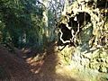
An eroded sunken lane on the Greensand Ridge

