
Haslemere facts for kids
Quick facts for kids Haslemere |
|
|---|---|
| Town and civil parish | |
 The High Street |
|

Haslemere
|
|
| Area | 23.27 km2 (8.98 sq mi) Civil Parish |
| Population | 17,279 (2021 Census) |
| • Density | 743/km2 (1,920/sq mi) |
| OS grid reference | SU9032 |
| • London | 62 km (38 mi) north east |
| Civil parish |
|
| District | |
| Shire county | |
| Region | |
| Country | England |
| Sovereign state | United Kingdom |
| Post town | Haslemere |
| Postcode district | GU27 |
| Dialling code | 01428 |
| Police | Surrey |
| Fire | Surrey |
| Ambulance | South East Coast |
| EU Parliament | South East England |
| UK Parliament |
|
Haslemere is a lovely town in the southwest of Surrey, England. It's about 62 kilometers (38 miles) southwest of London. The town includes the villages of Shottermill and Grayswood. Together with nearby Hindhead and Beacon Hill, they form the area known as the Haslemere civil parish. This area is special because it's where the counties of Surrey, Hampshire, and West Sussex meet.
A big part of Haslemere is in the area where the south branch of the River Wey begins. This river starts on Blackdown in West Sussex. The main parts of Haslemere and Shottermill are in the valleys of this young river. Many local roads here are narrow and steep. The National Trust owns a lot of land in the area. This includes Swan Barn Farm. To the north, you'll find the Surrey Hills National Landscape, and to the south, the South Downs National Park.
Haslemere probably started as a planned town in the 1100s. It was given permission to hold a market in 1221. By the early 1500s, it became a special area called a Parliamentary borough. This meant it could send two representatives to the House of Commons until 1832. The town really started to grow in the late 1800s. This happened after the London to Portsmouth railway line opened in 1859. In Victorian times, it became a hub for the Arts and Crafts movement. The International Dolmetsch Early Music Festival started here in 1925. Haslemere became an Urban District in 1913. Later, in 1972, its status changed to a civil parish with a town council.
Shottermill grew from a small village near one of the watermills on the River Wey in the 1500s. It began to expand in the 1880s. It joined the Haslemere Urban District in 1933. Grayswood was a small farming community until the late 1800s. It became its own church parish in 1901.
Contents
- Discovering Haslemere's Name Origins
- Exploring Haslemere's Geography and Landscape
- A Look Back at Haslemere's History
- Public Services and Community Support
- Getting Around Haslemere: Transport Links
- Learning in Haslemere: Schools and Education
- Places of Worship in Haslemere
- Haslemere's Vibrant Culture
- Sports and Recreation in Haslemere
- Notable Buildings and Landmarks
- Parks and Open Spaces in Haslemere
- Famous People Connected to Haslemere
- Images for kids
- See also
Discovering Haslemere's Name Origins
The first mention of a settlement in Haslemere was in 1180. It was called the "Chapel of Piperham." This chapel belonged to the church in Chiddingfold. The town was recorded as Heselmere in 1221. It was also called Haselmere in 1255 and 1441. Other old spellings include Hasulmere (1310) and Hesselmere (1612).
The "mere" part of the name likely refers to a lake or pond. This pond was on the west side of the High Street. It could be seen until at least 1859. The "hasle" part might come from the common hazel tree. It could also be linked to the Heysulle family from Chiddingfold. They owned land in the area until the 1300s.
Grayswood appeared as Grasewode in 1479. It was also called Grasewood in 1537. The "gray" part might come from the Old French name "Gerard." It could be connected to Gerardswoded, mentioned near Witley in the 1300s.
Shottermill was first recorded as Shottover in 1537. The modern spelling appeared in 1583. It refers to a watermill owned by the Shotter family.
Exploring Haslemere's Geography and Landscape
Haslemere is a town in the Waverley area of Surrey, England. It is very close to the borders of both Hampshire and West Sussex. This makes it the most southerly town in Surrey. The main road between London and Portsmouth, the A3, is to the west. A branch of the River Wey is to the south. Haslemere is about 19 kilometers (11.9 miles) southwest of Guildford.
The town is surrounded by hills. Blackdown is to the south, reaching 280 meters (920 feet) high. Gibbet Hill is to the north, at 272 meters (894 feet). In the past, Gibbet Hill was a place for executions. Many highwaymen were executed there. The roads around Haslemere were known to be dangerous. Today, much of the heathland and woodland is protected by the National Trust. It's a popular spot for walkers.
Great Walks and Trails in Haslemere
Haslemere is the starting point for the Greensand Way footpath. This path stretches for 177 kilometers (110 miles) to Hamstreet in Kent. It follows the high Greensand Ridge. Haslemere is also one end of the shorter The Serpent Trail. This trail connects to the Sussex Border Path.

Haslemere's Hills and Unique Soil
The land in Haslemere varies a lot in height. In developed areas, it ranges from 205 meters (673 feet) to 97 meters (318 feet) above sea level. The lowest point is in the northeast. Here, a stream gently curves north, following the railway line. This stream is the longest source of the River Arun. The west stream, the River Wey south branch, flows around Headley. It then joins the north branch in Tilford and heads towards Guildford.
The soil here is quite special. It's a "freely draining very acid sandy and loamy soil." This type of soil is not very fertile. Its natural plants include acid grasses and coniferous trees. To the east of Haslemere, the soil is more fertile. This area is the start of the Low Weald soil.
A Look Back at Haslemere's History


The earliest record of Haslemere is from 1221. It was part of Godalming. The name describes hazel trees next to a mere (lake). The lake is gone today. But a natural spring in West Street might have been its source. High Street is a watershed. Water from the west goes to the North Sea. Water from the east goes to the English Channel.
In the 1300s, Haste Hill was the main settlement. There might have been a church there. Haslemere was given a special permission, called a charter, by Richard II in 1394. This right was confirmed by Elizabeth I in 1596. Today, this special status is celebrated with the Charter fair. It happens every two years on the High Street. There's a statue of Elizabeth I in Charter Walk.
Haslemere was once a "rotten borough." This meant it sent two Members of Parliament to the government. This continued until 1832. One MP was Carew Raleigh, son of Sir Walter Raleigh. Haslemere grew again when the Portsmouth Direct Line railway was built. This line connected Haslemere to London Waterloo and Portsmouth Harbour railway stations. In Victorian Britain, Haslemere became a popular place to live. It's still a town where people live and travel to London or Portsmouth for work.
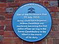
During the railway construction, a sad event happened. In July 1855, a police officer named Inspector William Donaldson was killed. This happened when he was trying to keep order among railway workers. Five men were arrested, and four were found responsible. Inspector Donaldson is buried in St Bartholomew's churchyard. A blue plaque on the Town Hall remembers him.
St Bartholomew's Church was originally a small chapel for Chiddingfold. It probably dates from the 1500s. It was rebuilt in 1871. Only the bell tower remains from the original building. The church has memorials to important local people. This includes Alfred Lord Tennyson, who lived nearby. One of the stained glass windows honors him.
Public Services and Community Support
Utilities: Water, Sewage, and Electricity
Before the 1500s, people got water from springs or the River Wey. The Haslemere Town Well was dug around 1500. Water was delivered to homes by carriers. Piped water began in the 1880s. Pumping stations brought water from Blackdown springs to public standpipes. The Wey Valley Water Company formed in 1898. A public water works opened in 1907. Grayswood got its water supply in 1920.

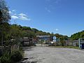
Until the late 1800s, sewage was collected in pits. This caused outbreaks of diseases like diphtheria. The first sewage treatment works in Haslemere opened in 1898. A second one followed in 1911. The Shottermill works was expanded and handled all sewage from the Haslemere area by 1933.
The first gas supply came to Haslemere in 1868-69 for street lighting. Gas mains reached Shottermill in 1903. Electric street lighting was installed between 1952 and 1955. The Hindhead and District Electric Light Company started in 1901. Mains electricity came to Haslemere and Shottermill in 1910.
Emergency Services: Keeping Haslemere Safe
The first known local police officer in Haslemere was in 1672. Policing became the job of the Surrey Constabulary in 1851. Grayswood got its first police officer in 1904. Haslemere Police Station closed in 2012. Today, Surrey Police is responsible for policing the town. The nearest police station is in Guildford.
_(geograph_5231950).jpg)
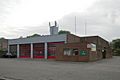
The Haslemere fire brigade started in 1877. It had a horse-drawn fire pump until 1907. Shottermill was served by a different brigade from 1906. Today, Surrey Fire and Rescue Service is the local fire service. Haslemere Ambulance Station is run by the South East Coast Ambulance Service.
Healthcare: Hospitals and Medical Care
The first recorded medical helper in Haslemere was Robert Shotter (1553-1639). He was a skilled surgeon. Today, the local doctor's office is at Haslemere Health Centre.
The first hospital in Haslemere was a small cottage hospital. It opened in 1898 with four beds. A new, larger hospital opened in 1923. Today, it's a community hospital. It has a minor injuries unit and offers various services.
Holy Cross Hospital, north of Shottermill, opened in 1917. It was a special hospital for tuberculosis. In the 1950s, it became a general hospital. Since 1991, it has focused on patients with severe brain and nerve conditions. It also offers physiotherapy.
.jpg)
During the First World War, there were two extra hospitals in the Haslemere area. They were called High Rough Hospital and Church Hill Hospital. They helped care for injured soldiers.
A special center for people with dementia opened in 1994. It provides day care for people with dementia. The nearest hospital with an Accident and Emergency department is the Royal Surrey County Hospital in Guildford.
Getting Around Haslemere: Transport Links
Many roads in Haslemere started as old paths. They are often narrow, winding, and steep because of the hills. The main road through Haslemere is the A286. It connects the town to Godalming (north) and Midhurst (south). The A287 passes through Shottermill. The B2131 is the main east-west road. It links Haslemere to Chiddingfold and Petworth (east) and Liphook (west).
.jpg)
Buses and Trains: Public Transport Options
Haslemere has bus routes connecting it to nearby towns and villages. Companies like Stagecoach and Waverley Hoppa operate these services.
.jpg)
Haslemere railway station is west of the town center. South Western Railway manages the station and runs all the trains. You can catch trains to London Waterloo (via Guildford) and to Portsmouth Harbour.
Cycling and Walking Trails
The Haslemere Link is a path for bikes. It connects to the Surrey Cycleway. It runs northeast from town. Haslemere is also the western end of the Greensand Way. This long-distance footpath is 174 kilometers (108 miles) long. The 103-kilometer (64-mile) Serpent Trail links Haslemere to Petersfield. The Sussex Border Path runs south of Haslemere.
Learning in Haslemere: Schools and Education
Local Schools for All Ages
St Bartholomew's Primary School started around 1813. A new building was built next to the church in 1869. The school moved to Derby Road in 1986.
Shottermill Infant School and Shottermill Junior School began as a Church of England school around 1846. It started with 40 students and one teacher. As more students joined, the school moved to new buildings. The county council took over in 1927. They built new schools on Lion Lane.
Grayswood Primary School started in 1862. It moved to its current site in 1905 as an infants' school. It expanded in 2015 to become a primary school for children aged 4 to 11.
Woolmer Hill School is a secondary school. It was built in 1950. It became part of the Weydon Multi-Academy Trust in 2017. About 800 students aged 11 to 16 attend this school.
Independent Schools in the Area
St Ives School is a private school for children aged 2–11. It started in 1911 and moved to Three Gates Lane in 1966. It became part of United Learning in 2013.
The Royal School is a private day and boarding school. It started in 1840 to educate daughters of naval officers. It became co-educational in 2011. In 2019, it also joined United Learning.
Former Schools and a Unique University Campus
Stoatley Rough School was founded in 1934. It educated children who had fled from Nazi Germany. It also took in children from the Kindertransport scheme. The school closed in 1960.
Wispers School was a private girls' boarding school. It moved to Oak Hall in 1969 and closed in 2008.

The UK campus of Jamia Ahmadiyya is an Islamic university. It moved to Haslemere in 2012. It trains missionaries from the Ahmadiyya Muslim Community. The campus building is a Grade II*-listed former country house. It was built in 1901.
Places of Worship in Haslemere
St Bartholomew's Church: A Historic Place

St Bartholomew's Church probably started as a chapel in the 1200s. The square tower at the west end might be from this time. Most of the building was rebuilt in 1871. The west window has 17th-century Flemish glass panels. The Holy Grail is shown in the Tennyson memorial window. The marble font is from 1870. The organ case has a 1900s Morris & Co. tapestry.
St Stephen's Church, Shottermill
St Stephen's Church was built in 1841. The tower was finished in 1846. The church was officially opened that same year. The chancel was designed around 1875. A Lady chapel was added in 1909–10. During a renovation in 2005–06, underfloor heating and a baptismal pool were added.
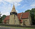
All Saints' Church, Grayswood: A Unique Design
_(8).JPG)
The church area of Grayswood was created in 1901. A local resident, Alfred Hugh Harman, paid for the church. All Saints' Church was designed by Swedish architect Axel Haig. It was built in a 13th-century style. The building was finished in 1902. It is made of Bargate stone with freestone details. The tower has a wooden belfry and a shingled spire. Inside, there is an embroidery of the Annunciation. There are also paintings of Moses and David. In the churchyard, there is a granite memorial stone for Axel Haig. It looks like a Viking sail.
St Christopher's Church
St Christopher's Church was built between 1902 and 1904. It is made of Bargate stone with ironstone details. The square tower has a checkerboard pattern. The east window was designed in 1928. A north chapel was added in 1935. Inside, there is a hanging icon of the crucifixion.
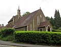
Church of Our Lady of Lourdes
_(3).JPG)
The Catholic community in Haslemere started in 1908. Services were held at Oaklands Hotel. In 1923, services moved to the High Street. The new church was finished in 1924. Our Lady of Lourdes was officially opened in 1932. Stained glass windows were installed between 1935 and 1937.
Haslemere's Vibrant Culture
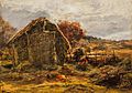
Art: Capturing Haslemere's Beauty
_-_A_Sheepfold,_Haslemere_-_NG_1481_-_National_Galleries_of_Scotland.jpg)
Many artists have painted landscapes of the Haslemere area. These include George Shalders and Alexander Fraser. The Haslemere Educational Museum has several artworks. These include a bust of Alfred, Lord Tennyson. It also has portraits by Frank Dicksee and Vera Cummings.
The town has public art. There is a bust of Elizabeth I by Malcolm Stathers. It celebrates the charter given to Haslemere by the queen. In 2019, four sculptures were commissioned from artist Andrew Brighty. They are inspired by the Arts and Crafts movement. The first two, Progress and Mimesis, were installed in 2020. The third, Serenade to the Sky, was unveiled in March 2021.
Music: A Town of Melodies
The musician Arnold Dolmetsch moved to Haslemere in 1919. He and his son, Carl Dolmetsch, helped bring back the recorder. They also revived other early musical instruments. In 1925, they started the Haslemere Festival. This became the annual International Dolmetsch Early Music Festival.
The Haslemere Musical Society started in 1923. It gives regular concerts. Haslemere Town Band was officially founded in 1837.
Haslemere Players: Local Theatre Group
The Haslemere Players is a local group that performs plays and musicals. It officially started in 1905. However, a group had been performing regularly since the 1890s.
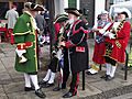
Haslemere Charter Fair: A Special Tradition
.jpg)
Permission to hold an annual fair was first given by Richard II in 1397. This was confirmed by Elizabeth I in 1596. The fair was brought back in 1984. It is held every two years on the early May bank holiday. The event takes place on the High Street and West Street. A competition for town criers is held as part of the fair. The winner receives the Tennyson Trophy.
Sports and Recreation in Haslemere
Leisure Centres: Staying Active

Haslemere Leisure Centre opened in 1998–99. It was refurbished in 2014–15. This included upgrading the gym and adding dance and cycling studios. The center is managed by Places Leisure.
The Edge Leisure Centre is on Woolmer Hill Road. It has an indoor dance studio and gym. It also has outdoor pitches for sports like football and rugby. There is an athletics track. A new artificial hockey pitch was installed in 2018.
Team Sports: Football, Cricket, and More
Shottermill & Haslemere Football Club was founded in 2001. The club plays its home games at Woolmer Hill Sports Ground.
Haslemere Cricket Club started in 1827. It has played at the recreation ground on Scotland Lane since 1922.

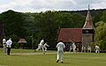
Cricket has been played on the village green at Grayswood since the early 1900s. The current Grayswood Cricket Club was reformed in 1989. They have won the I'Anson League championship three times.
Haslemere Hockey Club was founded in 1946. It plays its home games at Woolmer Hill Sports Ground. This ground has two AstroTurf pitches.
Haslemere Community Rugby Club started in 1950. It plays its home games at the Woolmer Hill Sports Ground.
Notable Buildings and Landmarks
Community Centres: Places to Gather
.jpg)
Grayswood Village Club started in 1905 as a reading room. The building was a school from 1862. It was bought by Frederick Albert Robers and given to the village.
The Haslewey Centre is a local community center. It has been run by a charity since 2003. It helps distribute Meals on Wheels. It has also housed the town post office since 2018.
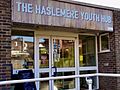
The Haslemere Youth Hub was relaunched in 2019. It provides a safe space for young people. It offers many activities and has a counseling service. High Lane Community Centre is also in the town.
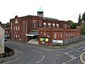
Haslemere Hall: Theatre and Cinema

Haslemere Hall is a theatre, cinema, and music venue. It opened in January 1914. Its design was influenced by the Arts and Crafts Movement. During the First World War, it was used as a training hall.
Haslemere Educational Museum: A Treasure Trove
Haslemere Educational Museum was founded in 1888. It was started by surgeon Jonathan Hutchinson. He collected biological, geological, and anthropological items. The museum moved to its current location on the High Street in 1926.
Replica Penfold Pillar Box: A Nod to History

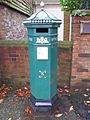
A replica Victorian pillar box was placed outside the Georgian Hotel in 1992. It is a copy of a "Penfold box." This design was standard for post boxes from 1866 to 1879. It honors local architect John Penfold, who designed it.
Town Hall: A Historic Building

Haslemere Town Hall was built in 1814. It was originally a market house. It replaced an older wooden building. It was given to the Parish Council in 1897. The upper floor was used for meetings until 1926.
War Memorials: Remembering Heroes
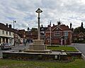
The limestone war memorial in Haslemere High Street was designed in 1920–21. It remembers 62 local people who died in World War I. The names of 47 people who died in World War II are also listed. A restoration project was done in 2018.
The Grayswood war memorial is south of the village. It is a stone cross. It remembers 19 local people who died in World War I and three who died in World War II.
Parks and Open Spaces in Haslemere
Grayswood: Woodland and Common Areas
The National Trust owns a 4.17-hectare (10.3-acre) area of old oak and yew woodland. It is between Grayswood village and Haslemere.
Grayswood Common and St George's Wood are also between Grayswood and Haslemere. They cover 16.43 hectares (40.6 acres). They are now owned by Waverley Borough Council.
Haste Hill: History and Nature Combined
Haste Hill is a 12.25-hectare (30.3-acre) woodland. It is southeast of the town. In the 1700s, an optical telegraph station was built on Haste Hill. It was part of a communication line between London and Portsmouth. It operated from 1822 until 1847.
Lion Green: A Community Hub
.jpg)
Lion Green was made a recreation ground in 1845. The green is used for community events. These include the Haslemere Classic Car Festival and the Haslemere Fringe Festival.
Recreation Ground: A Place for Play
The 3.44-hectare (8.5-acre) recreation ground is next to Scotland Lane. The land was bought in 1921. It was given to the local council in memory of those who died in the First World War. In 2015, it was protected by the charity Fields in Trust.
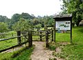
Swan Barn Farm: A Working Farm and Nature Spot
.jpg)
Swan Barn Farm is owned by the National Trust. It is an area of grassland and ancient woodland. The 28-hectare (69-acre) property includes two orchards. It is run as a smallholding. Areas are mown for haymaking. They are also grazed by Belted Galloway cattle.
Famous People Connected to Haslemere
- John Boxall (died 1571) – a Secretary of State, owned Burgage House.
- James Oglethorpe (1696–1785) – founded the Colony of Georgia. He was an MP for Haslemere and lived on High Street.
- Josiah Wood Whymper (1813–1903) – an artist, lived on High Street.
- George Bowdler Buckton (1818–1905) – a chemist and entomologist, designed his own house.
- George Eliot (1819–1880) – a famous novelist, wrote much of Middlemarch while living in Shottermill.
- Sir Francis Galton (1822–1911) – a very smart person who studied many things, died in Haslemere.
- George MacDonald (1824–1905) – a Scottish writer, lived in St George's Wood.
- Anne Gilchrist (1828–1885) – a writer, lived in Shottermill.
- Jonathan Hutchinson (1828–1913) – a surgeon, founded Haslemere Educational Museum.
- John Penfold (1828–1909) – an architect who designed the famous "Penfold" pillar box.
- Archibald Geikie (1834–1924) – a geologist, retired to Haslemere.
- Axel Haig (1835–1921) – an artist and architect, designed his own house.
- Robert Hunter (1844–1913) – a co-founder of the National Trust.
- William Cecil Marshall (1849–1921) – a sportsman, designed his own house.
- Arnold Dolmetsch (1854–1940) and his son Carl Dolmetsch (1911–1997) – famous musicians and instrument makers.
- Walter Tyndale (1855–1943) – an artist, lived in Haslemere.
- Cyril Edward Gourley (1893–1982) – a Victoria Cross recipient, lived in Grayswood.
- Margaret Hutchinson (1904–1997) – a teacher, writer, and naturalist.
- Robert Lochner (1904–1956) – invented the Bombardon Breakwater, used on D-Day.
- W. H. C. Frend (1916–2005) – a historian and archaeologist, was born in Shottermill.
- Robin Phillips (1940–2015) – an actor and director, was born in Haslemere.
- Rachel Portman (born 1960) – a composer, was born in Haslemere.
Images for kids
-
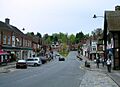
The High Street
-
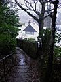
A footpath within the developed hills of central Haslemere
-
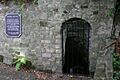
The Town Well, one of the old wells that served the area
-
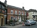
The White Horse pub in Haslemere
-
Haslemere Sewage Treatment Works
-
Blue plaque honoring Inspector William Donaldson, Town Hall
-
Haslemere Fire Station
-
High Rough Hospital during the First World War
-
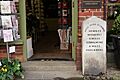
A historic mile post on High Street
-
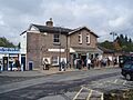
Front of Haslemere railway station
-
Haslemere campus of Jamia Ahmadiyya, formerly Branksome Conference Centre
-
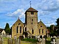
St Bartholomew's Church
-
All Saints' Church
-
Church of Our Lady of Lourdes
-
A Sheepfold, Haslemere (around 1868) by Alexander Fraser
-
Town criers at the 2012 Charter Fair
-
Haslemere Leisure Centre, 2010
-
Grayswood cricket, 2015
-
Haslemere Youth Hub
-
Haslemere Hall
-
A replica Penfold pillar box
-
Haslemere Town Hall and war memorial
-
Lion Green
-
Entrance to Swan Barn Farm

See also
 In Spanish: Haslemere para niños
