Leith Hill facts for kids
Quick facts for kids Leith Hill |
|
|---|---|
 |
|
| Highest point | |
| Elevation | 294 m (965 ft) |
| Prominence | 249 m (817 ft) |
| Listing | Marilyn, Hardy, County Top |
| Geography | |
| Location | Surrey, England |
| Parent range | Greensand Ridge |
| OS grid | TQ139431 |
| Topo map | OS Landranger 187 |
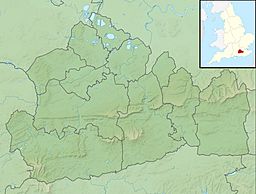
Leith Hill is a famous hill in southern England. It is the highest point of the Greensand Ridge. The hill is about 6.7 kilometers (4 miles) southwest of Dorking in Surrey. It is also about 40.5 kilometers (25 miles) southwest of central London.
Leith Hill reaches 294 meters (965 feet) above sea level. This makes it the second highest point in southeast England. Only Walbury Hill in Berkshire is taller, at 297 meters (974 feet). Leith Hill is the highest ground for about 49 kilometers (30 miles) around it.
The woodlands around the hill cover about 337.9 hectares (835 acres). This area is called the Leith Hill Site of Special Scientific Interest. This means it is a special place for nature. However, the very top of the hill is not part of this protected area.
The closest train station is Holmwood station. It is about 3.6 kilometers (2.2 miles) to the east. You can catch Southern trains from here to London Victoria.
Contents
Leith Hill Tower: A View from the Top
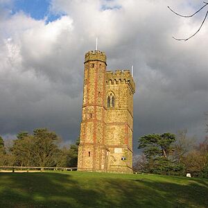
At the very top of Leith Hill, you will find an old Gothic tower. It was built a long time ago, between 1764 and 1765. A man named Richard Hull, who lived nearby, built it. He called it "Prospect House" at first. He wanted to make the hill taller than 300 meters (1,000 feet) above sea level. Another tower was built around the same time on Bredon Hill for a similar reason.
Leith Hill Tower is 19.5 meters (64 feet) tall. It used to have two nicely furnished rooms. Above the door, there was a Latin message. It said the tower was built for Hull's own fun and for others to enjoy. Hull even gave visitors special "prospect glasses." These were like small telescopes. Visitors could use them to see far away. On a clear day, you could see London and the English Channel, both about 25 miles (40 km) away!
When Richard Hull passed away in 1772, he asked to be buried under the tower. After his death, the tower was emptied. Its doors and windows were taken away, and it became a ruin. People filled the tower with rubble and concrete, and the entrance was blocked.
In 1864, William John Evelyn from nearby Wotton House decided to open the tower again. But the concrete made it very hard. So, an extra turreted side-tower was added. This new part allowed people to reach the top of the main tower.
At the very top of the tower, there is a special viewpoint indicator. It remembers Walker Miles. He helped start the Ramblers movement. This group encourages people to go walking in the countryside. Some people say that on a clear day, you can see 13 different counties from the top of Leith Hill Tower!
The National Trust fully repaired the tower in 1984. They removed the rubble and concrete. They also added safety features like a handrail on the narrow stairs. The bottom part of the tower was turned into a small shop. Leith Hill Tower is usually open to visitors every day. It has displays that tell the story of the tower. When you stand on top of Leith Hill Tower, you are at the highest point in the southeast of England.
History of Leith Hill's Ownership
The Evelyn family, who lived at Wotton House, owned Leith Hill for a long time. They owned it from the 1600s until the early 1900s. When Lt. John Evelyn passed away in 1922, his will required money to be raised for taxes on his property. So, the tower and five acres of land around it were put up for sale.
A group called the Commons and Footpath Preservation Society started a campaign. They wanted to save the land. A man named Wilfred James MacAndrew bought the land. He then gave it to the National Trust. The National Trust is a charity that protects historic places and natural beauty.
Leith Hill Place: A Composer's Home

Leith Hill Place was originally a house built around 1600. It had a gabled roof. Around 1760, Richard Hull changed its look completely. He gave it a Palladian style, which was very popular then.
In 1847, Josiah Wedgwood III bought the house. It stayed in his family for many years. His grandson was the famous composer Ralph Vaughan Williams. Ralph grew up in Leith Hill Place. When his brother passed away in 1944, Ralph inherited the house. He immediately gave it to the National Trust.
After that, the National Trust leased the house to Ralph's cousins, Sir Ralph Wedgwood and then Sir John Wedgwood. Later, it became a boarding house for a nearby college called Hurtwood House.
The National Trust opened Leith Hill Place to the public in 2013. It is now a special place that remembers Ralph Vaughan Williams. Josiah Wedgwood's widow, Caroline Darwin, created a beautiful rhododendron garden there. This garden is also open for people to visit.
Geology: How Leith Hill Was Formed
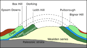
Leith Hill is part of the Greensand Ridge in Surrey. The rock that makes up Leith Hill is mostly called Lower Greensand. On top of this, there is a harder layer of rock called chert. The greensand was formed during the early Cretaceous period. This was a very long time ago! It was likely formed in a shallow sea where there was not much oxygen.
Over the next 50 million years, other layers of rock formed on top of the Lower Greensand. These included Gault clay and the chalk that makes up the North and South Downs.
After the Cretaceous period, the sea that covered southern England began to disappear. The land started to push upwards. The area called the Weald (which includes parts of Surrey, Kent, Sussex, and Hampshire today) was lifted up. This happened because of the same natural processes that created the Alps mountains. This lifting formed a dome-like shape called an anticline. This dome stretched all the way across the English Channel to a region in northern France called Artois.
At first, this dome was like an island. Rivers, like the Mole, Wey, and Arun, flowed through it. Over millions of years, the dome slowly wore away due to erosion. This erosion exposed the rock layers underneath. This is how the steep slopes, called escarpments, of the Downs and the Greensand Ridge were formed.
Search for Oil Near Leith Hill
An oil company once chose a spot on an old lane going up Leith Hill. They wanted to drill there to look for oil. However, many local groups and environmentalists protested. They also raised legal objections. Because of this, the company's permission to use the land from the Forestry Commission ran out before they could start drilling.
Later, the Minister for Environment decided not to renew the permission. This was because there were worries about how the drilling might affect the nearby ancient woodland. The oil company has said they plan to find a new place to look for oil in the same area. But local people have said they will continue to oppose any new drilling attempts.
Leith Hill's Role in Mapping
Leith Hill Tower was a very important spot for mapmaking. It was the starting point (or meridian) for the 6-inch and 1:2500 Ordnance Survey maps of Surrey. This means it was a key reference point used to create detailed maps of the area.
 | May Edward Chinn |
 | Rebecca Cole |
 | Alexa Canady |
 | Dorothy Lavinia Brown |


