
River Mole facts for kids
Quick facts for kids River Mole |
|
|---|---|

|
|

Map showing the River Mole (dark blue)
and part of the River Thames (light blue) |
|
| Country | England |
| Counties | West Sussex, Surrey |
| Districts / Boroughs | Horsham, Crawley, Mole Valley, Reigate and Banstead, Elmbridge |
| Towns | Crawley, Horley, Dorking, Leatherhead, Cobham, Surrey, Esher, Walton-on-Thames, Hersham |
| Physical characteristics | |
| Main source | Baldhorns Copse Rusper, Horsham, West Sussex 105 m (344 ft) 51°7′30″N 0°16′26″W / 51.12500°N 0.27389°W |
| River mouth | River Thames East Molesey, Elmbridge, Surrey 6 m (20 ft) 51°24′4″N 0°20′21″W / 51.40111°N 0.33917°W |
| Length | 80 km (50 mi) |
| Discharge (location 2) |
|
| Discharge (location 3) |
|
| Discharge (location 4) |
|
| Discharge (location 5) |
|
| Basin features | |
| Basin size | 512 km2 (198 sq mi) |
The River Mole is a river in southern England. It flows into the famous River Thames. The Mole starts in West Sussex near Horsham and travels northwest through Surrey for about 80 km (50 miles). It joins the Thames at East Molesey, right across from Hampton Court Palace. The river even gives its name to the Surrey area called Mole Valley.
The River Mole is special because it crosses the North Downs hills between Dorking and Leatherhead. Here, it carves a deep valley known as the Mole Gap. A lot of the land around the river has rock that doesn't let water through easily. This means the river's water level can change very quickly after heavy rain.
In the past, the river had a lot of pollution. But since 1995, the water has become much cleaner! Now, the River Mole has more different types of fish than any other river in England. There are also many special nature areas along the river, including twelve Sites of Special Scientific Interest (SSSIs). The Mole Gap is even important enough to be a Special Area of Conservation for all of Europe.
The river has inspired many writers and poets. This is especially true because in very hot summers, the riverbed can sometimes dry up between Dorking and Leatherhead. This happened most recently during the hot summer of 1976. However, the river's name probably doesn't come from this "disappearing" act. Experts think "Mole" might come from a Latin word for "mill" or from the name "Molesey" (which means "Mul's island"). Back in 1086, there were twenty mills on the river!
Contents
Where the River Mole Flows
The River Mole's drainage area is about 477 km2 (184 sq mi). This is about 5% of the entire River Thames area above Teddington. The area gets about 761 mm (30.0 in) of rain each year. The most rain falls around Crawley, with about 800 mm (31.5 in) annually. The highest point in the Mole's area is Leith Hill, which is 265 m (869 ft) high. Most of the river's water comes from surface runoff, especially from places like Gatwick Airport and the towns of Horley and Crawley. This means the river's flow changes quickly with rainfall.
The River's Journey: Upper Mole

The River Mole starts in a place called Baldhorns Copse, about 700 m (0.4 mi) south of Rusper in West Sussex. At first, it flows south for about 1 km (0.6 mi) to a small lake. Then, it turns east through countryside towards Crawley. The first small streams that join the Mole come from the northern part of St Leonard's Forest.
The Mole then flows past the northern edge of Crawley. Here, it is joined by its first big tributary, Ifield Brook. This brook drains Ifield Mill Pond. The river then goes under the Gatwick Airport runway through a special tunnel built in 1985. The river's path inside the airport has been changed several times. In 1999, some of its natural bends were put back to help with airport expansion.
The Mole enters Surrey south of Horley. Here, it meets the Gatwick Stream, another tributary. A large water treatment plant discharges water into the Gatwick Stream. During dry times, this water can make up to 75% of the Mole's flow downstream. The Mole flows west of Horley, heading north towards Sidlow. Here, the Earlswood Brook joins the Mole, bringing water from the towns of Reigate and Redhill.
From Sidlow, the Mole turns northwest towards Brockham. Many smaller streams join the river from the west. An old weir at Betchworth was updated in 2004 to add two water turbines. These turbines use the river's flow to make electricity. About 90% of this power goes into the main electricity grid for homes and businesses. The rest powers the Betchworth Park Estate. The river then flows past Betchworth Castle to Pixham, near Dorking. Here, the Pipp Brook joins the Mole.
The Mole Gap: Where the River Disappears
Between Dorking and Leatherhead, the Mole cuts through the North Downs hills. This creates a deep valley called the Mole Gap. On the side of Box Hill, there's a 170-metre-high (560 ft) river cliff. Because the ground here is chalk, which lets water through, the river water can actually sink into the ground through holes in its bed and banks. These are called swallow holes. This means the river can have less water, or even dry up completely, in this section during very hot summers.
The river's path through Norbury Park was made straighter when the railway was built in 1837. But in 1997, a bend was put back to improve the park area. The entire Mole Gap is part of the beautiful Surrey Hills Area of Outstanding Natural Beauty.
The River's Journey: Lower Mole

At Leatherhead, the Mole leaves the chalky ground and flows northwest over London Clay, which doesn't let water through. Here, the water that sank into the ground earlier comes back up through springs in the riverbed. The next major stream, The Rye, joins the Mole north of Leatherhead. Then, the M25 motorway crosses the river. At Cobham, the river makes a big bend around Painshill Landscape Garden. Here, a large 11-metre (35 ft) waterwheel lifts water 5 metres (16 ft) from the river to fill an ornamental lake in the park.
From Painshill Park, the river flows northeast towards the Thames. It passes west of Esher Commons and forms the border between Hersham and Esher. After heavy flooding in 1968, the river was changed near East Molesey to help prevent future floods. Finally, the Mole splits into two branches near the Island Barn Reservoir at Molesey. The smaller northern branch is still called the River Mole. The southern branch is known as the River Ember. These two rivers flow on either side of the reservoir, then run side by side. They join up about 400 m (440 yd) before meeting the River Thames, just above Teddington Lock.
Long ago, before the last Ice Age, the River Thames flowed a different way. It's thought that the Mole used to join the River Wey near Byfleet. Then, it flowed northeast to meet the old Thames near Ware. Today, the Mole and Wey are less than 2 km (1.2 mi) apart at their closest point. During the Ice Age, a huge ice sheet blocked the old Thames path. The melting ice caused the Thames to find a new route, flooding the Mole–Wey valley and creating its current path through London.
River Life: Ecology and Water Quality
Cleaner Waters for Wildlife
The water quality of the River Mole and its smaller streams has greatly improved since the 1990s. In 1990, only 23% of the river was considered good quality. By 2002, this jumped to 60%! This is because of improvements at water treatment plants. Also, Gatwick Airport now sends its surface water to special lagoons for cleaning before it goes into the river.
In the 1970s, some people thought the Mole was too polluted to ever recover. But others believed it was still a "charming Surrey stream" where you could catch fish. While there have been some pollution incidents since 2000, they are less common. For example, in 2003, a chemical spill from Gatwick Airport killed many fish. The airport was fined for this. Another sewage leak in 2003 also harmed fish. However, overall, the river's health has gotten much better.
Amazing River Animals
The marsh frog (a non-native frog from Europe) is now common in the upper Mole. Another non-native frog, the edible frog, has also been seen in some of the Mole's streams.
The River Mole has the most different kinds of fish of any river in England! The Gatwick Stream has fish like brown trout, brook lamprey, and eels. In 2003, parts of the upper River Mole were improved to create gravel areas for fish to lay eggs. This helps fish like chub, dace, and roach. Some non-native fish, like zander, have also been found in the lower Mole since the 1980s.
In the Mole Gap, between Dorking and Leatherhead, you can find chub, dace, barbel, and brown trout. Barbel and brown trout are very sensitive to water quality, so their presence shows the river is healthy. Further downstream, the river used to have larger fish like chub, perch, pike, and eels. However, in recent years, chub and eel numbers have started to go down. North of Esher, an invasive weed called floating pennywort can block out sunlight, reducing oxygen and making it harder for fish to live.
The types of small creatures (invertebrates) in the river also depend on the ground. Snails and water scorpions are common where the river flows over London Clay. Crayfish like areas with high alkalinity, especially around Brockham. Streams flowing over Weald Clay are great homes for stoneflies, caddisflies, fast-swimming mayflies, and riffle beetles.
The beautiful demoiselle (a type of dragonfly) disappeared from the Mole in the 1960s because of pollution, but it has now returned! Other dragonflies like the white-legged damselfly and the downy emerald are also found here. The Mole is one of only three places in England where a rare river shingle beetle lives. A nationally rare parasitic plant called the greater dodder is also common along the River Mole.
Protecting the River's Nature
The Mole catchment area includes twelve Sites of Special Scientific Interest (SSSIs) that protect wetland habitats. The Mole Gap is part of a Special Area of Conservation and is a very important SSSI in Europe.
A section of the river near Leatherhead has been named a Local Nature Reserve. Even though there are many homes and businesses nearby, this part of the Mole is home to 20 different mammal species, 20 butterfly species, and 15 types of dragonfly. The area has different types of ground, creating a mix of habitats like scrub, woodland, hedges, banks, and meadows, as well as the river itself. The river also acts as a pathway for wildlife through the middle of Leatherhead.
West End Common, part of the Esher Commons, is managed by Elmbridge Borough Council. The River Mole forms its western border. This area has plants typical of old woodlands, like bluebells, marsh marigolds, and golden saxifrages.
Molesey Heath Local Nature Reserve is on the west bank of the Mole. It's an area of rough scrubland that used to be a landfill site. Despite its past, it's now a rich home for birds like the redshank and little ringed plover.
River History
What's in a Name?
The River Mole was first mentioned in old documents around AD 983 as Emen or Æmen. This name likely comes from an Old English word meaning "misty" or "causing mists." The name of the River Ember probably comes from this old name too.
The name Mole didn't appear until the 1500s. It was first seen as Moule in 1577. The famous writer William Camden used the Latin name Molis in 1586, and Michael Drayton was the first to use Mole in his poem in 1613. On a map from 1611, the part of the river that sometimes disappears is shown with hills and the words "The river runneth under." However, the river's name probably doesn't come from this. The Oxford Dictionary of English Place Names suggests Mole might come from the Latin word mola (meaning "a mill") or from Molesey (meaning "Mul's island").
Ancient Discoveries
The earliest signs of people living along the upper Mole are from the Mesolithic Period (20,000–7000 BC). Tools like arrowheads and knives have been found. In the lower Mole, a flint axe from this period was found near Cobham in 1965. In 1877, a very old dug-out canoe was found where the Mole meets the Thames. This canoe is now kept at the Pitt Rivers Museum in Oxford.
The Mole Gap and North Downs were settled later, during the late Stone Age. A large axe from the Neolithic period was found in Westhumble in 1952. A flint mine from the same time was discovered at East Horsley.
Important finds from the Bronze Age include a bronze sword found near the river north of Charlwood. In 2003, a small collection of weapons, including two axes, was found in Norbury Park.
Boats and Canals
It's not entirely clear how much the Mole was used for boats in the past. In the late 1200s, a manor south of Leatherhead bought a "shout," which was a type of boat used to carry goods to market. Some people think stone from quarries in Reigate was sent to London using the river.
In the 1600s, there were attempts to make parts of the river navigable (meaning boats could travel on it). In 1664, a law was passed to make the Mole navigable from Reigate to the Thames, but this plan was never carried out. The only river in Surrey that was fully made navigable is the River Wey.
Today, you can navigate the Mole for about 400 m (440 yd) from where it meets the River Thames to Molember Weir. You can also paddle a canoe between Brockham and Fetcham if you have the right license.
World War II Defenses
During the Second World War, several places along the Mole were fortified to defend London from invasion. A defense line called GHQ Line B ran along the North Downs, crossing the Mole Gap and following the river to Horley. Between Betchworth and Box Hill, the river's north bank was made steeper to stop vehicles from crossing. Concrete cylinders were placed at Boxhill Farm as an anti-tank measure. Gun mounts and pillboxes (small concrete forts) were also built to protect bridges. An anti-tank ditch was dug from the Stepping Stones eastward.
The river crossing at Sidlow Bridge was heavily defended. Pillboxes were built on the north bank, and concrete anti-tank "dragon's teeth" were built upstream to stop armored vehicles.
Crossing the River Mole
Mole Gap Crossings
The North Downs Way walking path crosses the river at Box Hill using seventeen hexagonal stepping stones. These stones often get covered by water after heavy rain. The current stones were put in place in 1946, replacing ones destroyed during World War II to prevent invasion. This spot is popular for fishing and families, but swimming is not advised due to water quality in some areas. A nearby pub is even named "The Stepping Stones."
When the Burford Bridge was rebuilt in 1937, workers found signs of a Roman ford (a shallow place to cross a river) at this spot. This suggests that Stane Street, an old Roman road, crossed the river here.
Leatherhead Bridges

Leatherhead has three listed bridges, meaning they are historically important. The 14-arch Leatherhead Town Bridge is the oldest. The first bridge here was probably built in the late Middle Ages. It was rebuilt and made bigger in 1782–83. It's a long bridge made of red brick with stone details.
Just a few meters downstream from Leatherhead Bridge is the railway viaduct, which carries the Leatherhead to Dorking railway line over the river. This bridge was built in 1867 and has fancy architectural details.
The single-span Shell Bridge is in the grounds of Thorncroft Manor. It was built as a decorative feature in the park in the late 1700s. The bridge is mostly made of flint and has a large inverted scallop shell where the keystone would be. It was repaired in 1999 by Canadian engineers.
Cobham Crossings
A wooden bridge is believed to have existed at the site of Cobham Bridge since the 1100s. The current bridge was built in 1792. It has nine low arches and is mainly made of red brick with stone tops. The sides were rebuilt in 1914, and it became a listed building in 1953.
| List of crossings of the River Mole (from mouth to source) | ||||
|---|---|---|---|---|
| Name | Grid Reference | Type | Road/Railway | Notes |
| Confluence with River Thames | East Molesey, Surrey | |||
| Hampton Court Railway Station | Railway | Hampton Court Branch Line | ||
| Hampton Court Way Bridge | Road | A309 | ||
| Tanner's Bridge | Footbridge | |||
| Hersham Viaduct | Railway | |||
| Albany Bridge | Road | A244 | Named after the Duchess of Albany. The current concrete bridge dates from 1965. | |
| Burhill Bridge | Road | Built in 2008, replacing an older bridge. | ||
| A3 River Mole Bridge | Road | A3 | Opened in 1976. | |
| Cobham Bridge | Road | A245 | ||
| Painshill Park Bridge | Footbridge | A steel and timber bridge. Part of it is a drawbridge to control access to Painshill Park. | ||
| Downside Bridge | Road | The medieval bridge was rebuilt in 1786 but washed away in 1968 floods. The current bridge opened in 1971. | ||
| Ash Bridge | Bridleway | River Lane, Stoke D'Abernon |
Built in 1990 to replace an old ford. | |
| Cobham Viaduct | Railway | New Guildford Line | The original viaduct was washed away by floods in 1968. | |
| M25 River Mole Bridge | Road | M25 | ||
| Stoke D'Abernon Bridge | Road | A245 | ||
| Railway Bridge | Railway | Bookham Branch Line | ||
| Railway Bridge | ||||
| Waterway Road Bridge | Road | B2122 | ||
| Town Bridge | ||||
| Thorncroft Bridge | ||||
| Young Street Bridge | Road | A246 | Concrete girder bridge. | |
| Pressforward Bridge | Road | Built around 1790, refurbished in 1990. | ||
| Weir Bridge | Road | Grade II listed. Early to mid-19th-century brick bridge. | ||
| Railway Bridge | Railway | Epsom to Horsham line | ||
| Swanworth Bridge | ||||
| Cowslip Bridge | Road | |||
| Railway Bridge | Railway | Epsom to Horsham line | Three arch bridge | |
| Burford Bridge | Road | A24 | ||
| Stepping Stones Footbridge | Footbridge | North Downs Way | Erected in 1992 to replace the original bridge. | |
| Stepping Stones | Ford | North Downs Way | ||
| Deepdene Viaduct | Railway | Guildford to Redhill Line | A five-arch brick viaduct built in 1847-48. | |
| Castle Mill Footbridge | Footbridge | |||
| Boxhill Bridge | Footbridge | The original road bridge was destroyed in 1968 floods. | ||
| Deepdene Bridge | Road | A25 | Opened in 1927. | |
| Borough Bridge (Brockham) | Road | A single track bridge built in 1737, rebuilt in 1991. | ||
| Betchworth Bridge | Road | Single track bridge built in 1842, refurbished in 1993. | ||
| Rice Bridge | Footbridge | |||
| Flanchford Bridge | Road | Severely damaged by flooding in 2013, but rebuilt. | ||
| Sidlow Bridge | Road | A217 | ||
| Lee Street Bridge | Road | |||
| Long Bridge | Road | A23 | ||
| London Road Bridge | Road | A23 | Built in 1957 as part of the A23 diversion around Gatwick Airport. | |
| Gatwick Airport | Runway and taxiways |
The river passes under the airport in a 425 m (465 yd) long concrete tunnel built in 1957. | ||
| Stafford Bridge | Road | |||
| Granthams Bridge | Road | |||
| Lambs Green Bridge | Road | |||
| Rusper Court Bridge | Bridleway | |||
| Baldhorns Park Bridge | Bridleway | |||
| Source of River Mole | Baldhorns Copse, Rusper, West Sussex | |||
Watermills Along the Mole
The Domesday Book from 1086 listed twenty mills on the River Mole!
Mills on the Upper Mole
Horley Mill was first mentioned in the early 1200s. The last mill building was taken down in 1959, but the mill house is still there.
The first mill at Sidlow was built during Saxon times. The final mill on this spot was demolished in 1790, but you can still see parts of the old mill leat (the channel that carried water to the mill).
A mill at Brockham was mentioned in 1634, and you can still see parts of its mill race (the channel for the mill wheel).
Mills on the Lower Mole
Slyfield Mill near Stoke d'Abernon is also mentioned in the Domesday Book. It was used for processing wool and grinding corn.


Five of the mills mentioned in the Domesday Book were in the area of Elmbridge.
Downside Mill in Cobham was once owned by Chertsey Abbey. It was used for many things, including processing corn, paper, iron, and even making electricity. The current building is from the 1700s.
Cobham Mill, downstream from Leatherhead, had two mills for grinding corn. In 1953, the larger mill was demolished. The remaining red brick mill is from 1822 and was used until 1928. It has been fully restored by the Cobham Mill Preservation Trust and is now open to the public on certain Sundays.
Esher Mill, also called Royal Mill, was used to process corn, brass wire, paper, and even books. After a series of fires, the buildings were demolished in 1978.
East Molesey Upper Mill was used to make gunpowder for a time. The island where it stood is now part of the gardens of a housing development.
East Molesey Lower Mill, also known as Sterte Mill, also made gunpowder before going back to grinding corn. An old timber building was replaced by a brick one in the 1820s.
There was also Ember Mill, located on the banks of the old River Ember.
River Ember Flood Channel and Meeting the Thames

The River Mole originally flowed into the River Thames where the Hampton Court bridge is now. This was about 500 m (1,600 ft) upstream from where it meets the Thames today.
However, in the early 1930s, when Hampton Court Way and the bridge were built, the River Mole was redirected. Now, it flows into the River Ember. Both rivers then enter the Thames through a single, wider, and straighter channel that used to be only for the River Ember. More changes were made to these rivers after serious floods in 1947 and 1968 to help prevent future flooding.
The Mole in Books and Poems
The river has inspired many authors and poets, especially because it can sometimes dry up between Dorking and Leatherhead in very hot summers.

In The Faerie Queene (published in 1590), Edmund Spenser wrote about the river:
- And Mole, that like a nousling mole doth make
- His way still under ground till Thamis he overtake.

In Poly-Olbion (published in 1612), the poet Michael Drayton described the River Thames's journey:
- As still his goodly traine yet every houre increast,
- And from the Surrian shores cleer Wey came down to meet
- His Greatnes, whom the Tames so gratiously doth greet
- That with the Fearne-crown'd Flood he Minion-like doth play:
- Yet is not this the Brook, entiseth him to stay.
- But as they thus, in pompe, came sporting on the shole,
- Gainst Hampton-Court he meets the soft and gentle Mole.
- Whose eyes so pierc't his breast, that seeming to foreslowe
- The way which he so long intended was to go,
- With trifling up and down, he wandreth here and there;
- And that he in her sight, transparent might appeare,
- Applyes himselfe to Fords, and setteth his delight,
- On that which might make him gratious in her sight.
- But Tames would hardly on: oft turning back to show,
- For his much loved Mole how loth he was to go.
- The mother of the Mole, old Holmsdale, likewise beares
- Th'affection of her childe, as ill as they do theirs:
- But Mole respects her words, as vaine and idle dreames,
- Compar'd with that high joy, to be belov'd of Tames:
- And head-long holds her course, his company to win.
- Mole digs her selfe a path, by working day and night
- (According to her name, to shew her nature right)
- And underneath the Earth, for three miles space doth creep:
- Till gotten out of sight, quite from her mothers keep,
- Her foreintended course the wanton Nymph doth run;
- As longing to imbrace old Tame and Isis son...
He also wrote that the Mole "runnes into the earth, about a mile from Darking in Surrey, and after some two miles sees the light againe."
John Milton (1562–1647) called the river:
- sullen Mole that runneth underneath
Similarly, Alexander Pope (1688–1744) wrote in his poem Windsor Forest (1713):
- And sullen Mole that hides his diving flood
Robert Bloomfield (1766–1823) wrote these lines about the Mole Valley in his 1806 poem Wild Flowers:
- Sweet Health, I seek thee! Hither bring
- Thy balm that softens human ills;
- Come on the long drawn clouds that fling
- Their shadows o'er the Surry-Hills.
- Yon green-topt hills, and far away
- Where late as now I freedom stole,
- And spent one dear delicious day
- On thy wild banks romantic Mole.
- Ay there's the scene! Beyond the sweep
- Of London's congregated cloud,
- The dark-brow'd wood, the headlong steep,
- And valley paths without a crowd!
- Here Thames I watch thy flowing tides,
- Thy thousand sails am proud to see;
- But where the Mole all silent glides
- Dwells Peace - and Peace is wealth to me.
Mary Drinkwater Bethune's poem The River Mole or Emlyn Stream (1839) includes:
- Who may count back that forgotten time
- When first the waters forced an outlet here:
- When the foundations of these stedfast hills
- Were shaken, and the long imprisoned stream
- Flowed through the yawning chasm? That awful day
- Yet leaves its trace. The waters find their way,
- Now laughing in the sun - now swallowed up
- In caverns pervious to their course alone,
- They leave their channel dry, and hide awhile
- Their silent flow; like bitter tears, unshed
- From the dim eye, before a careless world
- Unheeding of our grief; but swelling still
- In the full heart, which leaves unsoothed, unseen,
- And broods o'er ruined hopes, and days gone by.
Streams Joining the Mole
The main streams that flow into the River Mole are the Ifield Brook, Gatwick Stream, Earlswood Brook, Pipp Brook and The Rye. A full list of these streams is below.
| Table of tributaries of the River Mole | |
|---|---|
| Left | Right |
| Confluence with River Thames at East Molesey | |
| River Ember as tributary | |
| Dead River | |
| River Ember distributary | |
| Cobham | |
| Bookham Brook | |
| Pachesham Brook | |
| The Rye | |
| Fetcham Mill Stream | |
| Mole Gap | |
| Pipp Brook | |
| Tanner's Brook | |
| Shag Brook | |
| Gad Brook | |
| Wallace Brook | |
| Leigh Brook | |
| Baldhorns Brook | |
| Deanoak Brook | |
| Sidlow | |
| Earlswood Brook | |
| Salfords Stream | |
| Burstow Stream | |
| Spencer's Gill | |
| Hookwood Common Stream | |
| Gatwick Stream | |
| Mans Brook | |
| Runway of Gatwick Airport | |
| Crawter's Brook | |
| Ifield Brook | |
| Reubens Gill | |
| Source at Rusper, West Sussex | |
River Branches
Images for kids
-
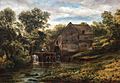
The Mill at Dorking, by Henry Hewitt, a view of Castle Mill in 1869
.jpg)
