
Horley facts for kids
Quick facts for kids Horley |
|
|---|---|
 High Street, Horley |
|

Horley
|
|
| Area | 11.24 km2 (4.34 sq mi) |
| Population | 22,076 (civil parish, 2011) or 22,693 (built-up area) |
| • Density | 1,964/km2 (5,090/sq mi) |
| OS grid reference | TQ2843 |
| Civil parish |
|
| District |
|
| Shire county | |
| Region | |
| Country | England |
| Sovereign state | United Kingdom |
| Post town | Horley |
| Postcode district | RH6 |
| Dialling code | 01293 |
| Police | Surrey |
| Fire | Surrey |
| Ambulance | South East Coast |
| EU Parliament | South East England |
| UK Parliament |
|
Horley is a town in Surrey, England. It is located south of Reigate and Redhill. The border with West Sussex is very close to the south. Crawley and Gatwick Airport are also nearby.
Horley has its own businesses and shops. It has a long high street with many stores. Because of its location, it is a good place for people who travel to work. It has good train links from the railway station and bus services from the bus station.
Contents
What's in a Name?
The name Horley first appeared in writing in the late 1100s. Back then, it was called Horle. Later, it was known as Horleg and Horlei.
The second part of the name, -ley, means a woodland or a clearing in a forest. The first part might come from a person's name, "Horne". Or it could mean the land was shaped like a horn.
Horley's Past
In ancient times, the area around Horley was a thick forest with lots of water. During the Saxon period, the land of Horley was controlled by Chertsey Abbey. This was a Benedictine monastery.
In the Domesday Book of 1086, Horley was part of a larger area called Cherchefelle. This area later became known as Reigate. The land then passed to King Henry VIII in 1539. This happened when he closed down the monasteries.
About 1 kilometre (0.6 miles) east of Horley, you can find the remains of Thunderfield Castle. This was a ring and bailey castle from the 1100s.
.jpg)
In 1602, Christ's Hospital in London took ownership of Horley. An old map of the area from that time is kept in the Guildhall in London. This map shows that Horley was made up of three small villages. These villages were built around a huge open common area.
One village was near St Bartholomew's Church. Another was by the River Mole. The third was in Horley Row, where some of the oldest buildings in Horley still stand.
The common land was divided up in 1816. New roads were built, and the land was sold. In the early 1800s, special roads called turnpikes were set up. These allowed regular coach services to run from London to Brighton.
The railway arrived in 1841, and a station was built in the town. From that time, Horley began to grow. Its population has doubled since 1950. Many people now live in Horley and travel to London for work.
.jpg)
From 1904 to 1909, the Horley Motor & Engineering Co. made cars and vans. These vehicles were sold under the names Horley and No Name.
The first scout patrol in Horley was formed in 1908. It was called the Pewit Patrol. Later, this patrol became the 1st Horley Scout Group. Robert Baden-Powell, who started the Scout movement, lived in Horley for a short time.
In 1972, a law changed the border between Surrey and West Sussex. This moved Horley, Gatwick, and Charlwood into West Sussex. However, many local people did not like this change. So, in 1974, Horley and Charlwood were moved back to Surrey. Gatwick Airport stayed in West Sussex.
In 2005, a plan called the Horley Master Plan was approved. This plan allows for almost 2,600 new homes to be built. This caused some debate because the area is part of the Metropolitan Green Belt. This is a protected area of land.
Where is Horley?
Horley is about 54 metres (177 feet) above sea level.
To the north of Horley is Salfords. Gatwick Airport is to the south, between Horley and Crawley. The village of Charlwood is to the west. Smallfield is to the east, across the M23 Motorway.
Sister Town

Horley has a special friendship with the town of Vimy, France. They have been "twinned" since 1991. This means they share cultural exchanges and visits.
Homes and People
The 2011 Census showed that Horley had 22,076 people living in 9,057 homes. About 31.7% of homes were owned outright. Another 39.3% were owned with a loan. The rest were rented.
There has been a big increase in homes and people in Horley since 2011. A large new housing area called Westvale Park has been built.
Local Businesses
In the past, the airline Dan-Air had its main office in Horley.
From 1947 to 1955, Wade Engineering Ltd made Wade superchargers in Horley. Horley was also home to the Matbro company. They made forklift trucks from the 1950s to the 1980s. They were pioneers in making telescopic handlers.
Today, about one-third of the people in Horley work in the town. Another third travel south to Gatwick and Crawley for work. The last third travel further to London, Redhill, and Reigate.
Arts and Entertainment

Horley is home to the Archway Theatre. This theatre is located under the arches of the Victoria Road railway bridge. It has a bar, a main stage, a studio theatre, and rehearsal rooms.
The main stage can seat 95 people, and the studio can seat 40. The theatre company puts on about 10 big shows each year. They also have smaller studio events and shows for young people.
Getting Around
Horley has bus services provided by Metrobus and Southdown. These buses connect Horley to Redhill, Three Bridges, Crawley, East Grinstead, Caterham, and Gatwick Airport. They also serve nearby villages like Charlwood and Smallfield.
Horley railway station is on the Brighton Main Line. Trains from Southern and Thameslink serve the station.
Media and News
Horley is in the BBC London and ITV London television regions. TV signals come from either the Reigate or Crystal Palace TV transmitters.
Local radio stations include BBC Radio Surrey (104.0 FM), Heart South (102.7 FM), and SUSY Radio (103.4 FM). SUSY Radio is a community-based station.
The local newspaper that serves the town is called Redhill, Reigate And Horley Life.
Schools in Horley
Horley has one secondary school, Oakwood School. There are also three primary schools: Manorfield, Trinity Oaks, and Langshott.
For younger students, there are two junior schools (Yattendon and Meath Green Junior) and two infant schools (Meath Green Infants and Horley Infants).
Horley does not have a sixth form for older students. Most students go to colleges in Redhill, Crawley, or Reigate to continue their studies. Examples include East Surrey College and Reigate College.
All the local schools are part of the Horley Learning Partnership. This group helps schools work together and share services. It also runs the Horley SureStart centre.
Sports in Horley
Horley is home to Horley Town F.C., a football club started in 1898. Horley also has clubs for cricket, hockey, tennis, bowls, and running. A rugby union club has also been active since the early 2000s.
Famous People from Horley
- Robert Emms is an actor who played Pythagoras in the TV show Atlantis. He grew up and went to school in Horley.
- Jack Fairman was from Horley, and a pub is named after him.
- Juliet Jacques is a writer and filmmaker who grew up and went to school in Horley.
- Dick Morrissey was a jazz musician and composer born in Horley.
- Robert Smith, a founding member of the band The Cure, lived in Horley as a child.
- Lol Tolhurst is a former member of The Cure who was born and lived in the town.
- Faye White was the former captain of the England Women's Football team. She grew up and went to school in Horley.
Images for kids
-
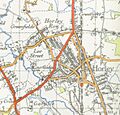
Map of Horley from 1946

See also
 In Spanish: Horley para niños
