
Box Hill, Surrey facts for kids
Quick facts for kids Box Hill |
|
|---|---|
| Part of the Mole Gap to Reigate Escarpment SSSI | |
|
IUCN Category IV (Habitat/Species Management Area)
|
|

Box Hill viewed from the south.
Photograph taken from Betchworth Park Golf Course. |
|

Box Hill
Location in Surrey
|
|
| Nearest town | Dorking, Surrey, England |
| Area | 11 km2 (4.2 sq mi) |

Map of Box Hill, showing the areas managed by the National Trust (purple), Surrey Wildlife Trust (turquoise) and Surrey County Council (green). The urban area of Box Hill village is shown in grey.
|
|
| Highest point | |
| Elevation | 224 m (735 ft) |
| Prominence | 49 m (161 ft) |
| Geography | |
| Parent range | North Downs |
| OS grid | TQ 178 514 |
| Topo map | OS Landranger 187 |
| Geology | |
| Age of rock | Cretaceous and Eocene |
| Type of rock |
|
Box Hill is a famous hill in Surrey, England. It is about 31 km (19 mi) south-west of London. The hill gets its name from the old box trees that grow on its steep slopes. These slopes face west and overlook the River Mole.
The western part of Box Hill is looked after by the National Trust. A small village called Box Hill is located on higher ground to the east. The highest point is Betchworth Clump, at 224 m (735 ft) above sea level. However, the Salomons Memorial, which is 172 m (564 ft) high, is the most popular spot for amazing views. It overlooks the town of Dorking.
Box Hill is part of the beautiful Surrey Hills National Landscape. It is also a special area for nature, known as the Mole Gap to Reigate Escarpment Site of Special Scientific Interest. Its slopes are home to many types of orchids and other rare plants. You can find 38 different kinds of butterfly here! A type of squash bug even got its name from Box Hill.
About 850,000 people visit Box Hill every year. The National Trust has a visitor centre with a cafe and gift shop. You can enjoy wide views of the western Weald from the North Downs Way. This is a long walking path that goes along the hill's south-facing slope. Box Hill was also a key part of the 2012 Summer Olympics cycling road races.
Contents
- Exploring Box Hill's Location
- The Village of Box Hill
- A Look Back at Box Hill's Past
- Understanding Box Hill's Geology
- Nature and Conservation at Box Hill
- Fun Activities and Places to See
- Interesting Spots to Visit
- Famous People Who Lived Here
- Groups That Help Box Hill
- How to Get to Box Hill
- Images for kids
Exploring Box Hill's Location
Box Hill is found at the south-eastern edge of the Mole Gap. This is a valley carved by the River Mole through the North Downs. Box Hill School is nearby in Mickleham, about 1.4 kilometres (0.9 mi) north. The hill looks over the town of Dorking to the south-west. It is about 30 km (19 mi) from central London. Box Hill is the 12th highest hill in Surrey.
The National Trust owns and cares for much of the western and north-eastern parts of Box Hill. In 1914, Leopold Salomons bought 95 ha (230 acres) of land to protect it from building. More land was bought or given between 1921 and 1999. Today, the Box Hill estate covers about 490 ha (1,200 acres). This includes Mickleham Downs to the north and Lower Boxhill Farm to the south.
The Village of Box Hill
| Box Hill | |
|---|---|
.jpg) St Andrew's Church, Box Hill village |
|
| Population | 1,320 (2019 estimate) |
| Civil parish |
|
| District |
|
| Shire county | |
| Region | |
| Country | England |
| Sovereign state | United Kingdom |
| Post town | Tadworth |
| Postcode district | KT20 |
| Dialling code | 01306 / 01737 |
| Police | Surrey |
| Fire | Surrey |
| Ambulance | South East Coast |
| EU Parliament | South East England |
| UK Parliament |
|
The village of Box Hill is east of the hill's summit. It is west of the Country Park managed by the National Trust. The oldest cottages were built in the 1800s. Most of the village was built in the first half of the 1900s. By 2005, there were over 800 homes, with more than 500 being mobile homes. St Andrew's Church opened in 1969, and the village hall opened in 1974.
A Look Back at Box Hill's Past
Ancient Times on the Hill
The oldest signs of people on Box Hill are two round barrows from the Bronze Age. These are near the Salomons Memorial. The larger barrow is 20 m (66 ft) wide and 2.2 m (7 ft 3 in) high. In medieval times, this barrow was used as a boundary marker for the parish of Mickleham. You can still see traces of old field boundaries on Burford Spur.
Medieval and Early Modern Periods
People disagree about when the box trees first grew on the hill. Some say Thomas Howard, 21st Earl of Arundel planted them in the 1600s. But older documents mention people with names like Atteboxe from the 1200s. This suggests box trees were already common then. The diarist John Evelyn visited in 1655 to see the "natural bowers" of box trees. Box wood was valuable for carving. Many trees were sold from the hill in the 1600s and 1700s.
The pillow mounds north-east of the Salomons Memorial are from the medieval period. They were likely artificial warrens for rabbits. High Ashurst warren was used until the late 1700s.
Box Hill in the 20th Century
In 1909, plans for a new tax made the owners of the Deepdene estate sell land on Box Hill. Sir Robert Hunter, a founder of the National Trust, helped Leopold Salomons buy 95 ha (230 acres) of land for £16,000. This protected the western side of the hill.
More land was bought by the National Trust in 1921 and 1923. By the mid-1980s, the estate was about 500 ha (1,200 acres). The most recent additions were farmland in the late 1990s. The National Trust also owns Headley Heath, which was bought in 1946.
Understanding Box Hill's Geology
Types of Rocks Found Here

Most of Box Hill is made of chalk. This chalk formed in the late Cretaceous period, about 100 to 66 million years ago. Back then, south-east England was covered by a warm, shallow sea. Tiny algae with calcite shells lived there. When they died, their shells sank to the seabed and formed the chalk we see today.
On top of the chalk, in many higher areas, is a layer of clay-with-flints. This clay likely formed during ice ages. It was created by the chalk breaking down and mixing with flint.
The sandy areas on Headley Heath are from the Quaternary period. These sands and gravels show that the sea shore was once here. In some places, the chalk comes to the surface, allowing both acid-loving and alkaline-loving plants to grow. This creates a rare chalk heath habitat.
How the Landscape Was Shaped

After the Cretaceous period, the land in southern England rose. The Weald area (including Surrey, Kent, and Sussex) was lifted by the same forces that created the Alps. This formed a dome-like shape that stretched across the English Channel. Over millions of years, this dome wore away, creating the hills of the Downs.
Chalk is a soft rock that can be worn down in many ways. It absorbs a lot of water, so freeze-thaw action can break it apart. This creates rubble and mud that can slide downhill. The River Mole has also cut a cliff called The Whites on the west side of Box Hill. Rainwater, which is slightly acidic, can also dissolve the chalk.
.jpg)
The eastern and northern edges of Box Hill have dry river valleys. These valleys were active during the last ice age. At that time, the ground was frozen, so water ran over the surface. These deep, twisting valleys suggest they were made by fast-flowing water, possibly from melting snow.
The northern side of Box Hill has six combes (dry river valleys). The Zig Zag Road climbs the westernmost combe. All these combes once had streams that flowed into the Headley Valley and then into the River Mole.
Quarries and Lime Kilns

Chalk and flint have been dug from Box Hill for centuries. You can see chalk blocks in some old local buildings. Walls made of flints held together by lime mortar are common in Surrey. Quicklime could be made by heating chalk in a kiln.
You can still see small chalk pits from before the Industrial Revolution. When the Dorking to Reigate railway line opened in 1849, new quarries opened. The Brockham Limeworks closed in 1935, but eight old kilns still stand. The larger Betchworth Quarry and Lime Kilns closed in 1960. Both sites are now Nature Reserves managed by Surrey Wildlife Trust. Bats now live in the old kilns.
Gravel was also dug from Headley Heath in the 1700s and early 1800s. This was likely used to build local roads.
Fossils Found Here
Many fossils have been found in the chalk at Box Hill. These fossils are from creatures that lived in a warm, shallow sea. They include:
- Brachiopods (like Terebratulina gracilis)
- Arthropods (like Janira quinquecostatus)
- Bivalves (like Spondylus spinosus)
- Urchins (like Holaster planus)
- Sponges (like Plinthosella squamata)
Nature and Conservation at Box Hill
Protecting the Environment

Box Hill is part of the Surrey Hills National Landscape. Most of the public areas, managed by the National Trust and Surrey Wildlife Trust, are part of a Site of Special Scientific Interest. They are also a Special Area of Conservation.
The chalk downland at Box Hill is home to many plant and insect species. The soil is thin and poor in nutrients. This stops tall, thirsty grasses from taking over. Each square metre of chalk downland can have up to 40 different plant species.
Without care, the grassland would turn into woodland. So, these areas are grazed by animals. This stops scrub from growing too much. The National Trust and Surrey Wildlife Trust use Belted Galloway cattle. These cows graze gently, allowing delicate wild flowers, like orchids, to grow. At Betchworth Quarry, goats help by eating tougher plants like gorse. Rabbits also help control plants, but their numbers dropped after a disease in 1953.

It's important to balance visitors' needs with protecting wildlife. When the Olympic cycling races were planned for Box Hill, some worried about damage to habitats. But studies showed that clearing some scrub for spectators might actually help nature. After the Games, a survey showed no major damage.
Amazing Plants and Animals
_-_geograph.org.uk_-_1359262.jpg)
_-_geograph.org.uk_-_863983.jpg)
Box Hill's chalk downland is home to many bats, lepidopterans (butterflies and moths), orchids, and the famous box trees.
Orchids
Many types of orchids grow on Box Hill. These include:
- Autumn lady's-tresses
- Bee orchids
- Bird's-nest orchids
- Common spotted orchids
- Common twayblades
- Fragrant orchids
- Pyramidal orchids
Other Wild Flowers
Wild garlic and bluebells grow under the trees near the River Mole. They give the area a special smell in spring.
Aquatic Plants
Damasonium alisma (starfruit) was brought back to Headley Heath in 2013. It had been gone since 2000. Now it grows in Brimmer Pond and Heath House Pond.
Trees

The box and yew woodlands on the steep slopes are very important. Other common trees include beech, ash, and oak. Smaller plants like holly and hazel grow beneath them.
Some invasive species found here are buddleia and Japanese knot weed. A fungal disease called Boxwood blight is also common.
Bats
Old buildings on Box Hill provide homes for bats. Grills protect their roosting spots. Three species live in the old Box Hill Fort:
Other bat species like the whiskered bat and Daubenton's bat have been seen in the old quarries.
Butterflies and Moths


Box Hill is home to 38 different kinds of butterflies. Some examples are:
- Silver-spotted skipper
- Adonis blue
- Chalkhill blue (found in grasslands)
- Purple emperor (found in woodlands)
Rare moths like the straw belle and orange-tailed clearwing are also found here.
Other Insects
A type of squash bug found across south-east England is named after Box Hill.
Fun Activities and Places to See

Box Hill Country Park
The western part of Box Hill is a Country Park. It is managed by the National Trust. Some old buildings are now a visitor centre, gift shop, and cafe. In 2011, a Natural Play Trail was built near the visitor centre.
There are car parks on the hill. From the Salomons Memorial, you can see amazing views over the Weald towards the South Downs. Juniper Top, on the north side, offers views towards Windsor Castle. The Country Park has many footpaths and bridleways for walking and riding. There are also self-guided trails.
Cycling at Box Hill
|
Zig Zag Road
|
|
|---|---|

Prudential Ride-London 100: Amateur cyclists ascending the Zig Zag Road (July 2016)
|
|
| Location | Box Hill, Surrey |
| Gain in altitude | 120 m (390 ft) |
| Length of climb | 2.5 km (1.6 mi) |
| Maximum elevation | 175 m (574 ft) |
| Average gradient | 5.0 % |
| Maximum gradient | 7.3 % |
| Website | Box Hill Olympic Circuit |
Box Hill has been popular with cyclists since the 1880s. The 2012 Summer Olympic cycling road races included a 15.8 km (9.8 mi) circuit around Box Hill. About 15,000 people watched the men's race in 2012.
The Box Hill Olympic circuit is usually cycled counter-clockwise. It starts south of Mickleham with a climb up the Zig Zag Road. From the National Trust Visitor Centre, the route goes east through Box Hill village. It reaches a height of 216 metres (709 ft). After 6.6 kilometres (4.1 mi), it turns north-west through Headley. Then it descends to the River Mole valley.
The Zig Zag Road is a steady climb of 120 metres (390 ft) over 2.5 kilometres (1.6 mi). It's sometimes compared to the famous Alpe d'Huez in the French Alps. The exact date it was built is unknown, but it appeared on a map in 1869. The Zig Zag Road is not a public road. It is closed one day a year to keep its private status.
After the Olympics, the Prudential RideLondon-Surrey 100 and London–Surrey Classic races have taken place every year. They always include a climb of Box Hill.
High Ashurst Activity Centre
High Ashurst is an outdoor education and activity centre. It is on the northern side of Box Hill, next to Headley Heath. Surrey Outdoor Learning and Development runs the centre. It used to be the grounds of a country house, which was taken down in the 1970s.
Boidier Hurst Campsite
The Scout Associations of Leatherhead and Epsom and Ewell own a 4.0-hectare (10-acre) campsite. It is between Box Hill village and Headley Heath. There are 11 areas for tents in a coppiced chestnut woodland. The campsite has washing, toilet, and kitchen facilities. Only Scouts, Guides, and school groups on Duke of Edinburgh's Award trips can use it.
Interesting Spots to Visit
Betchworth Clump
The highest point on Box Hill is Betchworth Clump, at 224 m (735 ft) above sea level. It is just east of Box Hill village. It was named after a group of beech trees that were there in the early 1900s. Today, thick woodland hides a water tower and transmitter mast. These are not open to the public.
The concrete water tower was built in 1930. It was updated in 2009 to last at least 25 more years. The 30-meter-high mobile phone mast was built in 2003.
Broadwood's Folly

This round flint tower is on the northern tip of Lodge Hill. It was built for Thomas Broadwood, a piano maker, around 1820. It is about 8 metres (26 ft) high and used to have two floors with a spiral staircase. An avenue of beech trees once connected it to Juniper Hall, but these were destroyed in a big storm in 1987. The tower might have been built to remember the Battle of Waterloo.
A sparkling wine from Denbies Wine Estate is named after this folly.
Labilliere's Grave

Peter Labilliere was born in Dublin in 1725. He joined the British Army at 14. After leaving the army, he became a political activist. He moved to Dorking around 1789 and often visited Box Hill to think. As he got older, he became very unusual. He died on June 6, 1800.
He asked to be buried head downwards on Box Hill. He said the world was "topsy-turvey" and would be set right if he was buried that way. He was buried on June 11, with thousands of people watching. The current memorial stone may not be in the exact spot of his burial.
Weypole and Stepping Stones

The Weypole is a flat, semi-circular area of 2.4 ha (5.9-acre) at the bottom of Box Hill. It is between The Whites and the River Mole. This area was once part of the grounds of Burford Lodge. Apple and cherry trees suggest it was an orchard.
A ford (a shallow place to cross) across the River Mole has likely been here since ancient times. Stepping stones were first noted here in 1841. They might have been put in by an owner of Burford Lodge. The crossing was officially reopened in 1946 by Prime Minister Clement Attlee. The new stones replaced those removed during World War II to prevent invasion. This spot is popular for fishing and families. The stones give their name to a pub in the nearby village of Westhumble.
Other Nearby Places
The Burford Bridge Hotel and Juniper Hall Field Studies Centre are at the foot of Box Hill, near the River Mole. Both have many historical connections to famous visitors and residents.
Famous People Who Lived Here
John Logie Baird
John Logie Baird (1888-1946), who invented the first working television system, lived at Swiss Cottage on Box Hill from 1929 to 1932. He continued his experiments there. He even set up a small power plant to run his equipment. He tested sending TV signals to a pub in Dorking. He also showed his Noctovisor, a device to see in the dark using infrared. Swiss Cottage was built in the mid-1800s and is a protected building. It is not open to the public.
Brodie Family
Brockham Warren was the home of the Brodie family. Sir Benjamin Collins Brodie, 1st Baronet (1783-1862) was a doctor and surgeon. He did important research on bone and joint diseases. He was a surgeon to King William IV and Queen Victoria. His son, Sir Benjamin Collins Brodie, 2nd Baronet (1817-1880), was a Chemistry Professor at Oxford University. He is known for his work on carbon and for discovering graphitic acid.
George Meredith

The author George Meredith (1828-1909) lived in Flint Cottage from 1868 until he died. He built a small writing room in his garden. The house is now a protected building and not open to the public.
Meredith wrote several works at Box Hill. His poem The Lark Ascending (1881) inspired the famous musical piece by Ralph Vaughan Williams. Another poem, Love in the Valley (1883), is said to have been inspired by a part of Box Hill called Juniper Bottom. The area opposite his cottage is called Barrie's Bank. This is because author J. M. Barrie supposedly waited there to get the courage to meet Meredith.
E. F. Warburg
The botanist Edmund Frederic ("Heff") Warburg (1908-1966) grew up at Boidier, a house near Headley Heath. His father loved gardening and had many unusual plants. Heff became a plant expert at Oxford University. His mother gave the land for Boidier Hurst Camp Site to the Scouts and Guides in 1946. Her family also donated the nearby Heath Plantation to the National Trust.
Edvard Westermarck
The Finnish philosopher and sociologist Edvard Westermarck (1862-1939) rented Keeper's Cottage as his summer home from 1910 to 1927.
Groups That Help Box Hill
The National Trust owns about half of the land on Box Hill. This includes the Country Park and Headley Heath. Surrey Wildlife Trust manages Brockham Limeworks and Betchworth Quarry and Lime Kilns. Both groups rely on volunteers to help with conservation and education.
The Friends of Box Hill (FoBH) is a local group that supports the National Trust. They help with wildlife plans and fund projects like buying equipment. They also organize social events and talks. The Friends of Headley Heath (FoHH) organize volunteer groups to help National Trust Rangers. Both groups are independent of the National Trust.
How to Get to Box Hill
Public Transport
Box Hill & Westhumble is the closest train station to the National Trust Country Park (about 500 m away). Trains from London Victoria and London Waterloo stop here. Dorking (Main) and Dorking Deepdene stations are about 1 km from the south-western part of the hill. Betchworth station is at the south-eastern corner.

Box Hill is also served by local and London bus routes.
Driving to Box Hill
To reach the National Trust Country Park from the A24 road, take the B2209 and the Zig Zag Road. However, this route is not good for buses. Another way is via the B2033 and Boxhill Road, which goes through Box Hill village. Headley Heath can be reached directly from the B2033.
Cycling Routes
National Cycle Route 22 runs along the northern edge of the hill. It goes via Lodgebottom Road and Headley Lane. The Surrey Cycleway approaches Box Hill from the west through Westhumble.
Walking Paths
The North Downs Way is a long-distance footpath from Farnham to Dover. It crosses the River Mole at the Stepping Stones. Then it runs along the top of the hill, past the Salomons Memorial. The Thames Down Link path follows an old Roman road called Stane Street across Mickleham Downs. It meets the North Downs Way near the Burford Bridge Hotel.
Images for kids
-
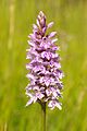
Common spotted orchid
-
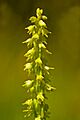
Musk orchid
-
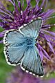
Chalkhill blue butterfly
-
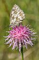
Marbled white butterfly
