
South Downs facts for kids
Quick facts for kids South Downs |
|
|---|---|
.jpg)
The Seven Sisters, near Eastbourne, viewed from Seaford Head
|
|
| Highest point | |
| Peak | Butser Hill |
| Elevation | 271 m (889 ft) |
| Dimensions | |
| Area | 670 km2 (260 sq mi) |
| Naming | |
| Etymology | Old English dūn, meaning 'hill' |
| Geography | |
| Country | England (United Kingdom) |
| State/Province | Hampshire, East Sussex, West Sussex |
| Range coordinates | 50°55′N 0°30′W / 50.917°N 0.500°W |
| Parent range | Southern England Chalk Formation |
| Geology | |
| Orogeny | Alpine orogeny |
| Age of rock | Cretaceous |
| Type of rock | Chalk |
The South Downs are a beautiful range of chalk hills in south-eastern England. They stretch for about 670 square kilometres (260 square miles). You can find them from the Itchen Valley in Hampshire in the west all the way to Beachy Head in East Sussex in the east.
These hills have a steep northern side, called an escarpment. From the top of this escarpment, you can see amazing views north across the Weald. The South Downs National Park is much bigger than just the chalk hills. It also includes large parts of the Weald area.
The South Downs are known for their rolling chalk hills with short, neat grass and dry valleys. They are one of the most important chalk landscapes in England. This area is one of four main chalk downland regions in southern England.
Even though the South Downs are less populated than other parts of South East England, some big seaside towns like Brighton and Hove have grown onto the chalk hills. People have lived in the South Downs for thousands of years. In the past, especially during Roman times, many people lived here. You can find many historical sites and old remains, like ancient forts, burial mounds, and old field boundaries.
Contents
- What Makes the South Downs Special?
- Exploring the South Downs: Fun Activities
- What Does "Downs" Mean?
- How Were the South Downs Formed?
- Where Are the South Downs Located?
- A Look Back: History of the South Downs
- The South Downs National Park: Protecting Nature
- Fun Things to Do in the South Downs
- Famous Landmarks of the South Downs
- The South Downs in Books and Poems
- Gallery
- Images for kids
- See also
What Makes the South Downs Special?
The South Downs are famous for their unique, short, springy grass. This grass is called old chalk grassland. It grew this way because sheep have grazed on the thin, well-drained chalk soils for centuries. Rabbits also helped keep the grass short.
How Farming Changed the Landscape
For a long time, farmers used a system called 'sheep-and-corn farming'. They would keep their sheep, especially the famous Southdown sheep, in certain corn fields. This helped make the soil more fertile with the sheep's droppings. Then, they would let the sheep graze on the downland.
However, things changed a lot starting in 1940 during World War II. The government wanted to grow more food in England. So, much of the grassland was ploughed up for farming. This changed the landscape and the types of plants and animals living there. Before the war, old chalk grassland covered 40-50% of the eastern Downs. Now, only 3-4% of it remains.
Protecting the South Downs Today
Because of these changes and the growth of nearby towns, a decision was made to create the South Downs National Park. This park officially started on April 1, 2011. Its main goal is to protect and restore the beautiful South Downs.
The South Downs are also recognized as a National Character Area (NCA 125) by Natural England. This means it's a special natural area with its own unique character.
Exploring the South Downs: Fun Activities
The South Downs are a very popular place for outdoor activities. Many people come here for walking, horse riding, and mountain biking.
The South Downs Way: A Long Adventure
A special long-distance path called the South Downs Way follows the entire length of the chalk ridge. You can walk or ride a horse along this path from Winchester to Eastbourne. There are also many other smaller paths and bridleways that connect to it.

What Does "Downs" Mean?
The word 'downs' comes from an old English word, dūn, which means 'hill'. Around the 1300s, the word started to mean 'hills with rolling grassland'. These hills are called 'South' Downs to tell them apart from the North Downs. The North Downs are another set of chalk hills that run about 30 kilometres (19 miles) away, parallel to the South Downs.
How Were the South Downs Formed?
The South Downs are made of a thick layer of chalk rock. This chalk formed about 60 million years ago during the Cretaceous Period. Back then, this area was covered by a shallow sea that stretched across much of northwest Europe.
The Story of Chalk and Fossils
The chalk itself is made from tiny skeletons of plankton. These tiny sea creatures lived in the ancient sea, which is why the chalk is white. You can find many fossils and bands of flint throughout the chalk. The chalk is divided into Lower, Middle, and Upper sections.
The Weald-Artois Anticline
The rocks in southeast England, including the chalk, were gently folded a long time ago. This folding created a dome-like shape called the Weald-Artois Anticline. Over time, the middle part of this dome wore away due to erosion. This left the steep northern side of the South Downs. On the other side, the North Downs formed.
Between these two chalk ridges, the land has worn away differently. This created other unique areas like the Greensand Ridge and the clay valleys of the Low Weald.
Water in the Chalk Hills
Because chalk is porous (meaning water can soak through it), there are many special streams called winterbournes along the northern edge. These streams only flow during the wetter parts of the year.
Where Are the South Downs Located?
The South Downs are a long chalk escarpment that stretches for over 110 kilometres (68 miles). They start near Winchester in Hampshire in the west and end at Beachy Head near Eastbourne in East Sussex in the east.
Behind the steep northern slope, the land gently slopes southwards for up to 7 kilometres (4.3 miles). From higher points in the High Weald and on the North Downs, the South Downs look like a tall wall on the horizon. Their grassy tops are dotted with groups of trees, like Chanctonbury Ring.
Where the Downs Meet the Sea
In the east, the hills meet the English Channel coast between Seaford and Eastbourne. Here, they form the amazing white cliffs of Seaford Head, the Seven Sisters, and Beachy Head. Beachy Head is the highest chalk sea cliff in Britain, standing 162 metres (531 feet) above sea level.
Parts of the South Downs
The South Downs can be thought of as having three main parts: the East Hampshire Downs, the Western Downs, and the Eastern Downs. There are also river valleys that cut through them. The Western Downs, west of the River Arun, have more trees, especially on the steep northern side. The Eastern Downs are more open and bare. This bare part is what many writers and artists, like Rudyard Kipling and Eric Ravilious, often wrote about.
Rivers and Ponds
Four rivers cut through the South Downs: the Arun, Adur, Ouse, and Cuckmere. These rivers create different landscapes. The chalk layers underground, called aquifers, and the winterbourne streams provide much of the water for nearby towns. You might also see Dew ponds, which are artificial ponds built to water livestock.
Highest Points of the South Downs
The highest point on the South Downs is Butser Hill. Its top is 270 metres (886 feet) above sea level. This large hill, located just south of Petersfield, Hampshire, was used regularly by people in ancient times. It is now a national nature reserve.
Within the wider South Downs National Park, the highest point is Blackdown in West Sussex, which is 280 metres (919 feet) above sea level. However, Blackdown is not geologically part of the South Downs. It's part of the Greensand Ridge.
Here is a list of some of the highest hills on the South Downs:
| Name of hill | Nearest town | Height | Notes |
|---|---|---|---|
| Butser Hill | Petersfield | 270 m (886 ft) | Highest point in the South Downs. |
| West Harting Down | South Harting | 229 m (751 ft) | |
| Beacon Hill | South Harting | 242 m (793 ft) | |
| Linch Down | Bepton | 248 m (814 ft) | |
| Littleton Down | East Lavington | 255 m (836 ft) | The summit, Crown Teglease, is the highest point on the Sussex Downs. |
| Glatting Beacon | Sutton | 245 m (803 ft) | |
| Chanctonbury Hill | Washington | 238 m (782 ft) | Site of Chanctonbury Ring hill fort |
| Truleigh Hill | Upper Beeding | 216 m (708 ft) | |
| Ditchling Beacon | Ditchling | 248 m (814 ft) | |
| Firle Beacon | Firle | 217 m (713 ft) |
A Look Back: History of the South Downs
Archaeological findings show that people have lived and used the Downs for thousands of years. You can see ancient Neolithic flint mines like Cissbury Ring, burial mounds like the Devil's Jumps, and hill forts like Chanctonbury Ring. These are important features in the landscape.
It's believed that the trees covering the Downs were cleared over 3,000 years ago. The short, grazed grass we see today is a result of sheep constantly grazing there.
The South Downs National Park: Protecting Nature
Plans to create a national park for the South Downs began in the 1940s. However, it wasn't until 1999 that the government strongly supported the idea. After a long public discussion from 2003 to 2009, the government announced on March 31, 2009, that the South Downs would become a national park. The South Downs National Park officially opened on April 1, 2011. This park includes not only the South Downs hills but also part of the western Weald, which is a different type of land.
The South Downs National Park replaced two older protected areas: the East Hampshire AONB and the Sussex Downs AONB.
Special Nature Reserves in the South Downs
The South Downs are home to several National Nature Reserves (NNRs). These are special places protected for their wildlife and natural features.
In the Sussex Downs, you can find:
- Kingley Vale, near Chichester. It has one of Europe's best yew forests, with some of the oldest living trees in Britain. It's also an important archaeological site.
- Castle Hill, between Brighton and Lewes. This is a great example of old, traditionally managed grassland.
- Lewes Downs (Mount Caburn), another traditionally managed chalk downland and an important archaeological site.
- Lullington Heath, near Eastbourne. This is one of the largest areas of chalk heath in Britain.
In the East Hampshire Downs, you can find:
- Butser Hill, near Petersfield. This is a large area of chalk grassland on the highest point in the South Downs. It's also an important historical site from the Bronze and Iron Ages.
- Old Winchester Hill, a grassland on the slopes of the Meon valley.
- Beacon Hill, a high-quality chalk grassland west of Old Winchester Hill.
Fun Things to Do in the South Downs
In 1923, a group called the Society of Sussex Downsmen (now the South Downs Society) was formed. Their goal was to protect the unique landscape of the area.
The South Downs are a popular place for walkers. There are over 3,200 kilometres (2,000 miles) of well-kept and easy-to-access trails. The main path is the South Downs Way. The Monarch's Way, a path that starts in Worcester, also crosses the South Downs and ends at Shoreham-by-Sea.
You can enjoy many sports on the Downs, including paragliding, mountain biking, horse riding, and walking. Every autumn, a challenging cross-country marathon called the Beachy Head Marathon takes place on the eastern Downs. It starts and finishes in Eastbourne. There's also the South Downs Trail Marathon, which goes from Slindon village to Queen Elizabeth Country Park.
Longer events, like a 160-kilometre (100-mile) running 'ultramarathon' and a 120-kilometre (75-mile) night-time mountain biking race, also use the South Downs Way.
Famous Landmarks of the South Downs

There are three famous landmarks on the Downs:
- The Long Man of Wilmington and the Litlington White Horse. These are huge figures carved into the chalk hills.
- The Clayton Windmills.
There is also a war memorial called The Chattri. It is dedicated to Indian soldiers who died in the Brighton area during the First World War. They were brought there for treatment after being injured fighting on the Western Front.

The South Downs in Books and Poems
Many writers and poets have been inspired by the South Downs.
- Rudyard Kipling, who lived nearby, called them "Our blunt, bow-headed whale-backed Downs."
- In 1920, poet Hilaire Belloc described them as "the great hills of the South Country" in his poem The South Country.
- Poet Algernon Charles Swinburne wrote about them as "the green smooth-swelling unending downs" in On The South Coast.
The naturalist-writer William Henry Hudson felt that "during the whole fifty-three mile length from Beachy Head to Harting the ground never rises above a height of 850 feet, but we feel on top of the world."
Poet Francis William Bourdillon also wrote a poem called "On the South Downs."
Many famous writers have lived near the South Downs:
- Jane Austen lived at Chawton on the edge of the Downs in Hampshire.
- The Bloomsbury Group often visited Monk's House in Rodmell, the home of Virginia Woolf.
- Alfred, Lord Tennyson had a second home at Aldworth, on Blackdown. Although Blackdown is part of the Weald, it is included in the South Downs National Park.
In Arthur Conan Doyle's short stories, Sherlock Holmes retires to a small farm on the Downs near Eastbourne. In the story "The Lion's Mane", Holmes solves a case while living there.
Graham Greene's first novel, 'The Man Within' (1929), is mostly set on and around the South Downs. The main character, Andrews, walks across the Downs to reach Lewes.
Gallery
-
Looking east along the Downs towards the Devil's Dyke, Sussex
-
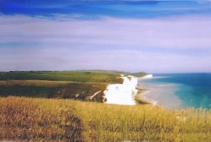
South Downs close to Beachy Head
-
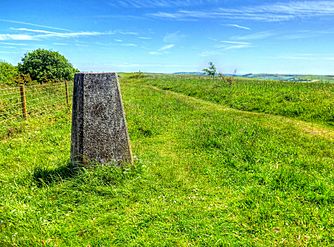
Trig Point on Kithurst Hill West Sussex. Located on the South Downs Way above the village of Storrington. 699 ft high at the summit.
-
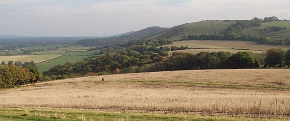
Typical topography (Treyford Hill): steep wooded northern slope (left), gently sloping southern slope of pasture and woodland.


Images for kids
-
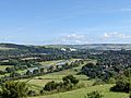
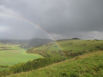
Photo taken near Lewes, East Sussex

See also
 In Spanish: South Downs para niños
