
River Cuckmere facts for kids
Quick facts for kids River Cuckmere |
|
|---|---|

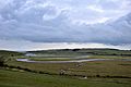
Looking West over Cuckmere Haven
|
|
| Country | England (East Sussex) |
| Physical characteristics | |
| Main source | Near Heathfield |
| River mouth | English Channel |

.jpg)
The River Cuckmere is a river in East Sussex, England. It starts near Heathfield on the southern slopes of the Weald. The name "Cuckmere" likely comes from an Old English word meaning "fast-flowing." This makes sense because the river drops over 100 meters (328 feet) in its first four miles (6.4 km). It flows into the English Channel and has the only natural, undeveloped river mouth along the Sussex coast.
Contents
What is the River Cuckmere Like?
The Cuckmere River has many smaller streams that feed into it at its start. The most important of these is the River Bull. The main part of the river begins at Hellingly.
Where Does the Cuckmere River Flow?
After flowing through the Low Weald, an area of farmland, the Cuckmere cuts a path through the South Downs. This creates its own beautiful valley. The river finally reaches the English Channel at Cuckmere Haven. This spot is located between Seaford and the famous Seven Sisters cliff face.
Why Does the River Cuckmere Bend and Curve?
The lower part of the river, in the floodplain, has many bends and curves called meanders. These natural loops are a key feature of the river. The Cuckmere Valley Nature Reserve is found in the lower part of the river's mouth, known as the estuary. This valley is very important for nature. It has been named a Site of Special Scientific Interest and is part of the South Downs National Park.
How Has the Cuckmere Valley Changed Over Time?
The Cuckmere Valley civil parish gets its name from the river. In the 1800s, people built defenses to stop the upper valley from flooding. They regularly dug out shingle (small stones) from the river's mouth and made the river banks taller.
Why Was the River Cuckmere Straightened?
In 1846, the river's path was made straight with an artificial cut. This cut mostly stopped flooding upstream, which used to reach the village of Alfriston. It also helped with watering crops. High river banks, called levees, were also built to protect areas from floods. Today, the area is a popular place for tourists. Tourism now brings more money to the local area than farming does. The river also flows at the base of the Litlington White Horse, a large horse shape carved into the hillside in 1924.
What Are the Plans for the Cuckmere Estuary?
In recent years, a group called the Cuckmere Estuary Partnership was formed. This group includes organizations like the National Trust, Natural England, the Environment Agency, and the Sussex Wildlife Trust. They are working together to make long-term plans for this natural area.
Government rules now say that expensive flood defenses should not be kept up if houses are not at risk. Also, scientists believe the area would be better for nature if it returned to its natural state. The partnership and the Environment Agency have suggested restoring the estuary. They have been talking to local people, businesses, and visitors about how to do this.
Why is Sea Level Rise a Concern for the Cuckmere River?
Currently, a shingle beach and tall river banks stop seawater from reaching the upper parts of the Cuckmere Valley. However, the Environment Agency expects sea level rise due to climate change. This will make it even more expensive to keep up the physical defenses. Current measures will not be enough.
The plan is to stop repairing the levees and let natural processes happen, including occasional flooding. The groups planning this believe that in the long run, restoring the saltwater estuary and marshes will create a richer natural home for plants and animals. They also think it will attract more wildlife and improve tourism.
What Are People Saying About the Plans?
The Environment Agency's plans have caused some debate in the valley. Some property owners are especially concerned. Some residents have created a group called "Rescue the Cuckmere Valley." They want to find a different solution than the proposed seasonal flooding. In early 2008, the Cuckmere Parish Council asked the Environment Agency to take smaller steps for now. They suggested protecting the existing cut while developing longer-term plans over the next 25 to 50 years.
Images for kids
-
Meander of the River Cuckmere

See also
 In Spanish: Río Cuckmere para niños
