Cuckmere Valley facts for kids
Quick facts for kids Cuckmere Valley |
|
|---|---|
| Area | 17.6 km2 (6.8 sq mi) |
| Population | 191 (2011) |
| • Density | 30/sq mi (12/km2) |
| OS grid reference | TQ523017 |
| • London | 50 miles (80 km) NNW |
| District |
|
| Shire county | |
| Region | |
| Country | England |
| Sovereign state | United Kingdom |
| Post town | POLEGATE |
| Postcode district | BN26 |
| Dialling code | 01323 |
| Police | Sussex |
| Fire | East Sussex |
| Ambulance | South East Coast |
| EU Parliament | South East England |
| UK Parliament |
|
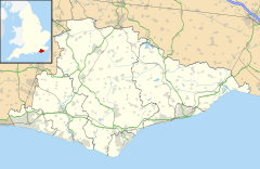
Cuckmere Valley is a beautiful area in East Sussex, England. It's a type of local government area called a civil parish. As its name suggests, it's found in the lower parts of the River Cuckmere. This valley is home to several small villages.
Contents
Exploring Cuckmere Valley's Villages
The Cuckmere Valley parish includes three main villages: Litlington, Lullington, and Westdean. There are also signs of an older settlement near the coast at Exceat. The Cuckmere Valley parish was created in 1990. Before that, Litlington, Lullington, and Westdean were separate parishes.
Discovering Litlington Village
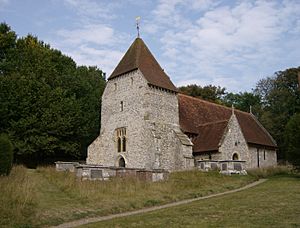
The name Litlington comes from an old Saxon word. It likely means "Litl's homestead," which was a type of farm or home. The village church is very old, built in the 1100s. It is named after St Michael the Archangel.
A famous person named Maria Fitzherbert once lived in Litlington. She was connected to George IV, who was King of the United Kingdom. She lived in a house called Clapham House.
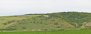
In 1924, a large chalk figure of a horse was carved into the hills near the village. This new horse replaced an older one from the 1800s. The local pub in the village is called the Plough and Harrow.
Visiting Lullington Village
Lullington is the most northern of the three villages. It's about 16 kilometers (10 miles) southeast of Lewes. The village sits on a hill of the South Downs. It's on the opposite side of the River Cuckmere from Alfriston.
A medieval village called Lullington Court used to be here. It was abandoned after a terrible sickness called the Black Death in the 1300s. The old village site is east of where Lullington is today.
The church in Lullington is very special. It's called the Church of the Good Shepherd. Many people believe it's the smallest church in all of England! It was rebuilt using only the original front part after a fire. Church services are only held in the summer. This is because the building does not have electricity.
Exploring Exceat's History
Exceat (pronounced ek-SEET) was once an important ancient village. The A259 road passes by it, just east of the River Cuckmere. The name "Exceat" might come from old words meaning "oak grove" or "wooded river."
After the Normans took over England, the village was given to Robert, Count of Mortain. He was the half-brother of William the Conqueror. Later, Exceat and its land were given to a religious house called Grestein Priory.
Until the 1300s, Exceat was a busy village with its own church. However, it faced attacks from French raiders. It also lost many people during the Black Death. By the 1400s, the village was mostly abandoned.
Today, Exceat has a Visitors Centre for the nearby Seven Sisters cliffs. There's also the Cuckmere Inn, a pub, across the Exceat Bridge over the Cuckmere River.
Discovering West Dean Hamlet
West Dean (sometimes called Westdean) is a small village or hamlet. It's located right next to Friston Forest. The church in West Dean is called All Saints Church. It has parts that date back to the Saxon times, like a window in its north wall.
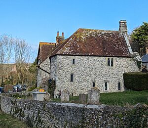
Next to the church is "The Old Parsonage." This is a very old house made of flint and stone. It was built by Benedictine monks in 1280. People have lived in this house continuously since then! The clergy (church officials) moved out in the 1970s, and now it's a private home.
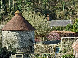
Across from the church, you can see the remains of a Norman-era manor house. A Norman-era dovecote (a building for doves or pigeons) is still well-kept. The South Downs Way, a popular walking trail, goes right through West Dean.
Important Natural Places
The National Trust owns land on the western side of the River Cuckmere. This land is south of the A259 road.
The Cuckmere Valley area also has three special nature sites. These are called Sites of Special Scientific Interest. They are Seaford to Beachy Head, Wilmington Downs, and Lullington Heath.
- Seaford to Beachy Head is a large area important for its plants, animals, and geology. It has many different natural homes for creatures. These are based on the chalk rock, which supports many types of plants and animals. Some of these species are very rare in the country.
- Wilmington Downs is another important area for nature. Its chalk grassland is home to several rare species of plants and animals.
- Lullington Heath is also special because of its unique chalk heath and grassland areas. These habitats are home to specific types of wildlife.
 | Madam C. J. Walker |
 | Janet Emerson Bashen |
 | Annie Turnbo Malone |
 | Maggie L. Walker |


